
Geocaching "Line tools" problem
Hello menion
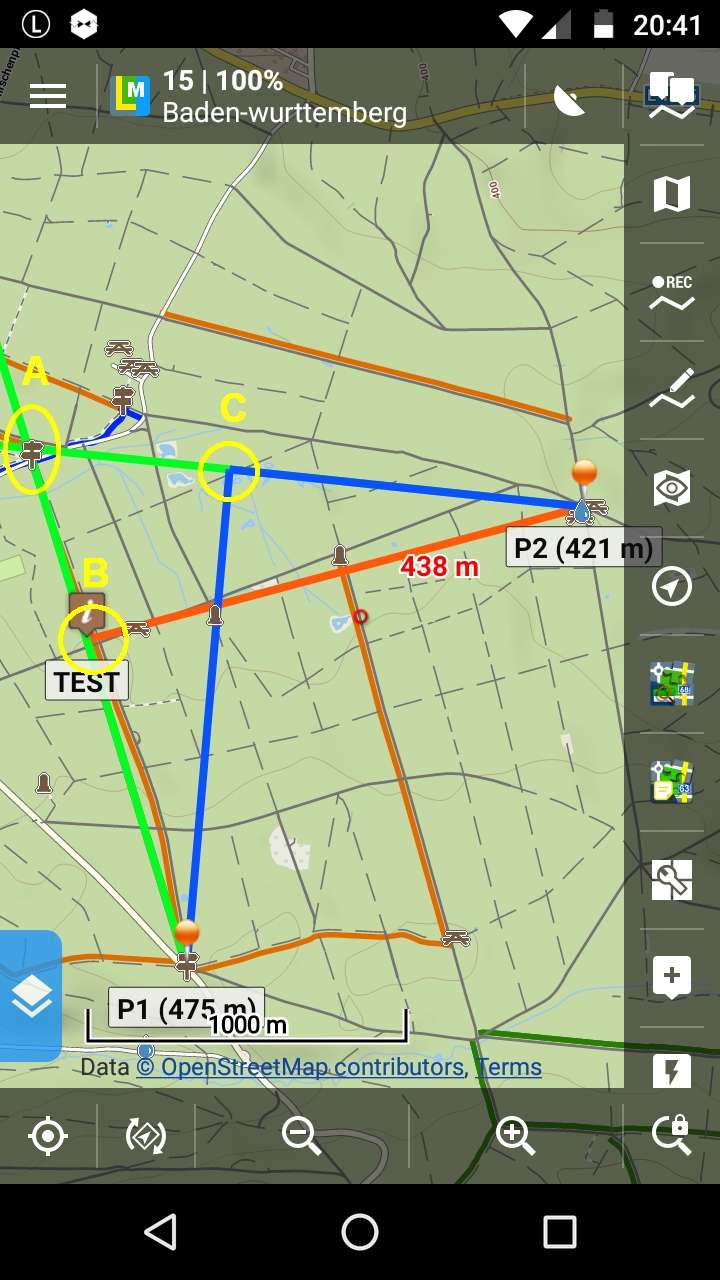
while solving a geocache i get wrong results with "single line" and "intersection" if startpoint of a projection isn´t mapcenter.
Task:
i didn´t know the distance of the intersection, so i use always e.g. 3000 m
P1 projection 343°
P2 projection 276°
first i center P1 on map and run single line projection, result > green line
next i center P2 on map and run single line projection, result > green line with correct result of intersection point A
if i use "intersection" the result of intersection calculated point is wrong !
example:
first i center P1 on map, use "intersection tab"
> first line "Map center" with projection values
> second line "P2" with projection values
wrong result intersection point B
or i center P2 on map, use "intersection tab"
> first line "Map center" with projection values
> second line "P1" with projection values
wrong result intersection point C
 The same problem
Good day balloni,
I'm trying to follow and simulate your issue, but even after a few attempts, I'm unable to simulate same problem. Should be possible to record for me short video, so I may follow exact steps like you do? Thank You!
Good day balloni,
I'm trying to follow and simulate your issue, but even after a few attempts, I'm unable to simulate same problem. Should be possible to record for me short video, so I may follow exact steps like you do? Thank You!
Hello menion
here it is
https://www.dropbox.com/s/1gllbj6c2vwkib6/Line%20tools.mp4?dl=0
Hello menion
here it is
https://www.dropbox.com/s/1gllbj6c2vwkib6/Line%20tools.mp4?dl=0
Thanks balloni, this helped ... it took me a while.
1:13 - you see that first point of line is set to "map center" and second point of line is set to "map center" as well. Same for second line
1:27 - you just created new second point of first line from "map center" with defined projection
1:41 - you just selected new point for first point of second line, all well till now
1:53 - you create new second point of second line again from map center!!! It is because second point is by default set to map center and you started projection from this defined point. So in last dialog with projection you needs to choose from which point projection starts!
It is same problem in 2:24. Nope, you did not set P1 to second point, you set P1 to first point.
Give it a try and choose correct start point for projections and I'm sure, it will work for you as expected.
Hello menion,
thanks for your detailed answer and at the end i understand how it work for now .......
For me it would be logically and more comfortable for user if a point is set as "start point", this point is set automatically from locus as start point for projection. Mapcenter make no sence in this case.
Hello,
it is needed to work on this screen (as on all others) with every point completely independently. So if you set first point to something, it is not logical to automatically set second point to same value, or is it? And because in this case, you wants to do projected point from second point, you firstly needs to set this second point as well (directly in "line" tab or later in "projection" screen).
Most useful here should be another screen, intersection defined not by two and two points, but by point and angle and point and angle. Not sure if such idea already exists here and if there will be interest ...
Hello menion
>Most useful here should be another screen, intersection defined not by
two and two points, but by point and angle and point and angle.<
exactly that would be a usefull screen!
Sorry, at the moment i can´t imagine a situation/task where i need function of current intersection.
So if you find little time to show me (and others) an example where first and second point of projection is different for understanding as screenshot or better as small video.
nice weekend
You never needed intersection of two lines, where both lines are defined by it's start and end points?
In your case here, we only talk about "how the second point" of lines is defined. Because there does not exists function "intersect two lines defined by start point and angle", you need to define second point by any alternative method, in this case by projection. I do not see big science behind it.
You may try to separate this function into three separates functions.
This is exactly what you are trying to do in single function "Intersection".
Replies have been locked on this page!