
Bogus negative altitude value
In Progress
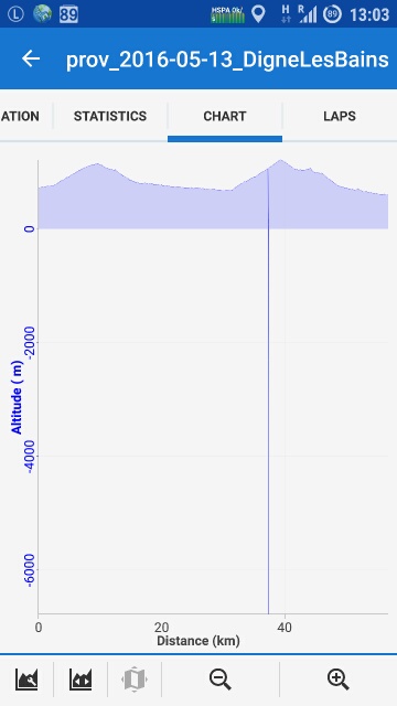
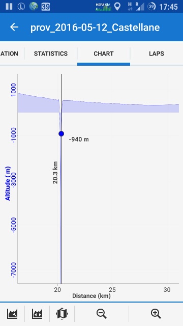
I have odd bogus altitude values since a few days... cycling Haute Provence in France. I assume they come from srtm data, I get those when calculating a route. I also get those when recording my own Track, which is a bit strange. I believe I set Locus to only use the pressure Sensor and no srtm optimization when recording. Maybe that indicates another problem in dealing with altitudes?
Anyway... I think Locus should ignore such bogus values silently, no matter if they come from GPS or pressure Sensor or srtm data. Altitudes below a few hundred negative meters (what's the lowest point on earth?) are just nonsense.
 The same problem
Ps, don't know if that's of significance, but I use the hires alps srtm data from viewfinderpanoramas. If you want to reproduce something to find a bug, calculate a google route for cars from Puget-Theniers to Digne-Les-Bains and look at the altitude chart. But some
if (altitude<-1000) skipeverything;
might be good in any case.
Good day joeloc,
don't know why, but by accident I missed this topic. Weird elevation values from custom SRTM files is known problem. Best possible solution is to use SRTM files downloaded directly over Locus Map, where all such troubles are already and no such values may appear.
Currently lowest place on Earth on dry land is near Dead sea ( https://en.wikipedia.org/wiki/List_of_places_on_land_with_elevations_below_sea_level ), around -400 metres. Petr, is there any chance that someone use HGT files with elevation of seabed? Because in such case, joeloc's condition will cause flat sea/oceans for such guys.
Replies have been locked on this page!