
This object is in archive!
Gap in shaded maps (without hight data and shading)?
Answered
I have Locus Pro. I bought LoMap of Hungary first. It works perfectly, with all shading and hight data.
However, when I also bought the LoMaps of surrounding countries (Austria and Slovakia) and added the shading to these new ones as well, a strange thing happened.
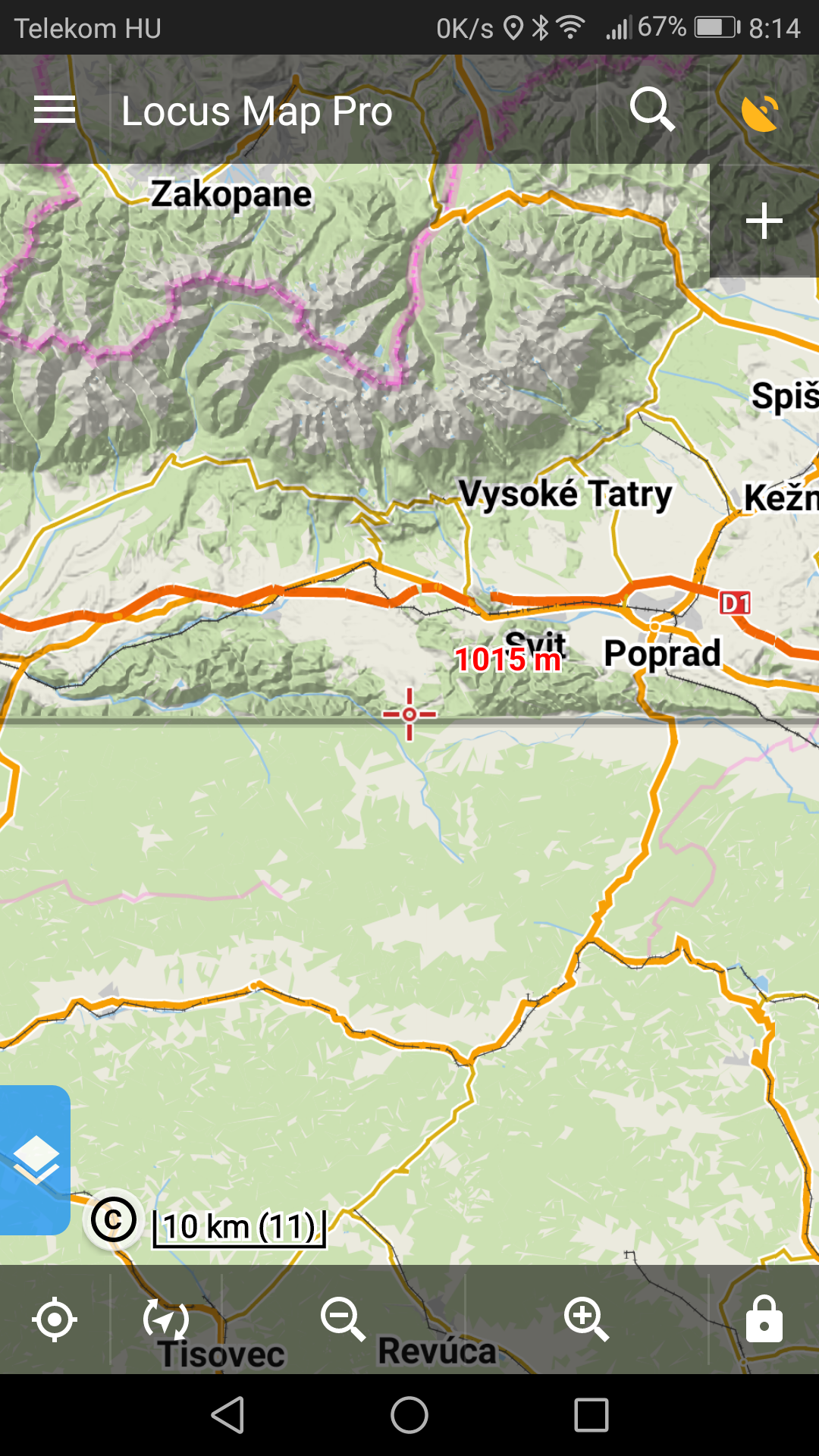
There is a gap (2-10km) all around Hungary that has the data, then there is a huge distance where there are no data, and hundrends of kilometers away the data start again.
I need these data (hight and shading) in the Slovensky Raj next week and I do not know how to obtain them.
I attach two screenshots to make this clearer.
 The same question
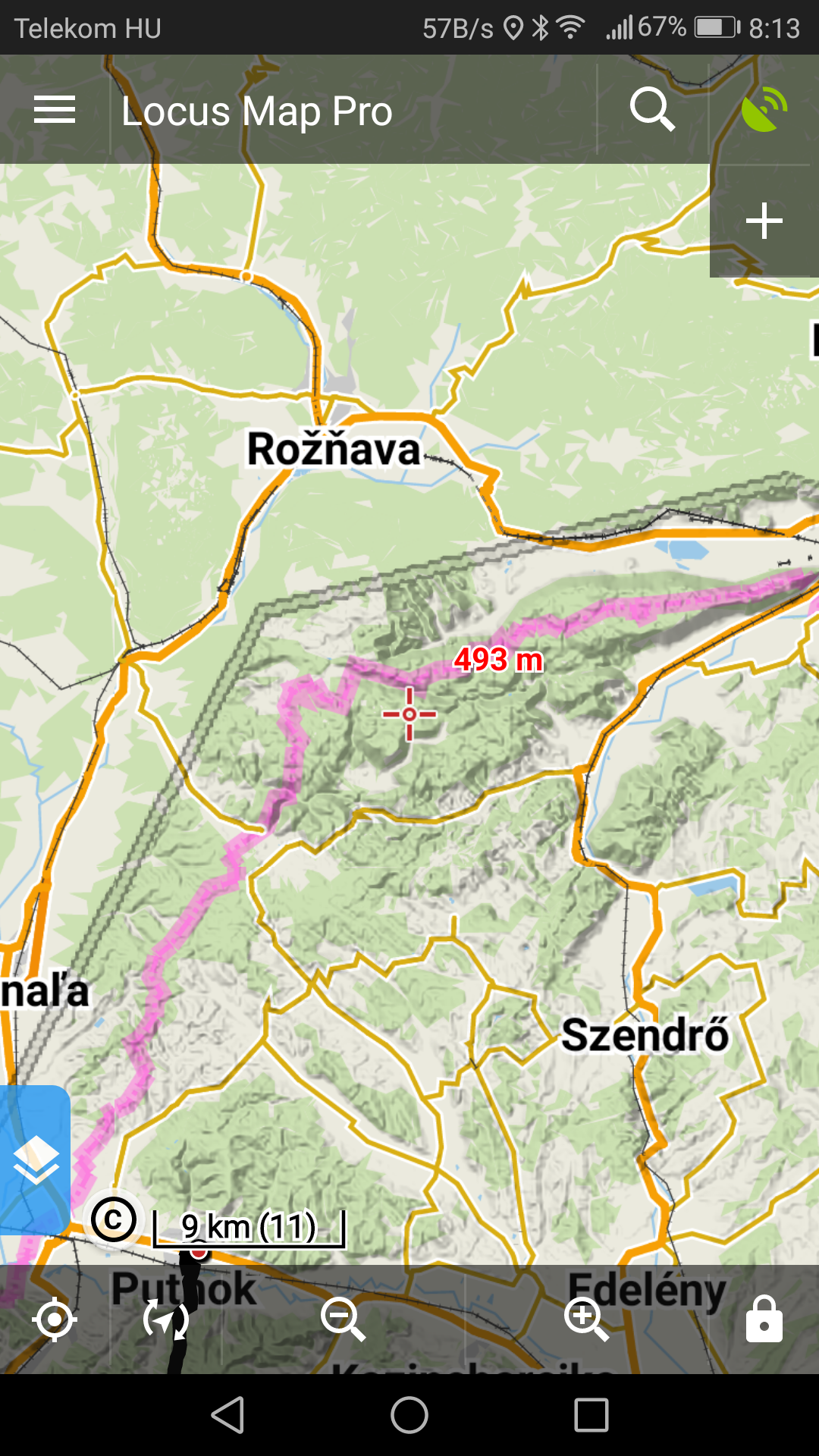
Hello,
that's quite interesting. In first step please try following:
Please let me know about progress.
BR Petr
Hello,
that's quite interesting. In first step please try following:
Please let me know about progress.
BR Petr
Dear Petr,
I did what you suggested.
Thank you, now I have the missing height data in all 3 countries.
I also have the shading when I zoom in.
(It belongs to the truth that when I zoom out I still lose the shading in those areas where originally I had neither the height data nor the shading, but I do not care much about this because what I most needed was the height data, and (when zoomed in) I also have the shading as well.
Thank you very much.
Yours,
Béla Melegh
2018-07-15 22:40 GMT+02:00 Locus Map <locus.map@asamm.com>:
Hello,
the hill shading is available till zoom-level=9. So for example when you zoom-out to see whole country the hill shading is no more available. This limitation is due to performance.
Thank you for understanding
BR Petr
Hello,
the hill shading is available till zoom-level=9. So for example when you zoom-out to see whole country the hill shading is no more available. This limitation is due to performance.
Thank you for understanding
BR Petr
Dear Petr,
thank you. However, unfortunately, this is still not an explanation for the phenomenon attached.
Do you know how to get this mended?
Béla Melegh
Locus Map <locus.map@asamm.com> ezt írta (időpont: 2018. júl. 17., K 11:35):
Dear Petr,
thank you. However, unfortunately, this is still not an explanation for the phenomenon attached.
Do you know how to get this mended?
Béla Melegh
Locus Map <locus.map@asamm.com> ezt írta (időpont: 2018. júl. 17., K 11:35):
Hello,
I thought that this issue was solved when you updated the elevation data. If I understand it correctly - when you zoom-in then the shading is visible and the "holes" appears only when you zoom-out. Is it correct?
BR Petr
Hello,
I thought that this issue was solved when you updated the elevation data. If I understand it correctly - when you zoom-in then the shading is visible and the "holes" appears only when you zoom-out. Is it correct?
BR Petr
No, unfortunately not.
I am trying to sum up the phenomenon.
Before you suggested the solution, I had no height data or shading in the previously indicated areas.
After you suggested the solution, the height data appeared in red numbers beside the red cross that marks the middle of the map. So now it is solved, works perfectly well.
Concerning shading, before you suggested the solution, I had no shading at all in the indicated areas. Now I do have shading, in levels 13-22, but not between 12 and 9. (In those areas where I originally had shading and height data as well, I still have all data and shading (bw zoom levels 9-22)).
What I sent to you as a screenshot, was a zoom level bw 9 and 12.
So, can you think of something?
If not, do not worry, because I have all height data and shading bw zoom levels 13 and 22, so this is much better than it used to be.
Thanks a lot,
Béla Melegh
Locus Map <locus.map@asamm.com> ezt írta (időpont: 2018. júl. 19., Cs 16:35):
Hello,
that's quite interesting issue. Please use arbitrary file manager app navigate to the folde /Locus/cache/map/shader/hill and delete all files in this folder.
Start Locus and check the shading.
BR Petr
Hello,
that's quite interesting issue. Please use arbitrary file manager app navigate to the folde /Locus/cache/map/shader/hill and delete all files in this folder.
Start Locus and check the shading.
BR Petr
Dear Petr,
Thank you. I did.
Now everything is fine and working.
Thanks again.
Béla Melegh
Locus Map <locus.map@asamm.com> ezt írta (időpont: 2018. júl. 20., P 12:35):
Dear Petr,
Thank you. I did.
Now everything is fine and working.
Thanks again.
Béla Melegh
Locus Map <locus.map@asamm.com> ezt írta (időpont: 2018. júl. 20., P 12:35):
Hello,
thank you for the info, I'm glad that's solved.
BR Petr
Hello,
thank you for the info, I'm glad that's solved.
BR Petr
Replies have been locked on this page!