This object is in archive!
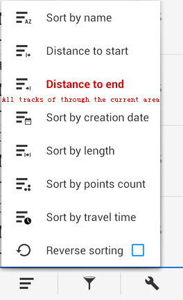
Tracks sort add a "All tracks of through the current area" ?
Completed
Because often we are interested only in the current area, such as the current windows of map.
However in sort menu, only support distance to start or end, only the two points ?.
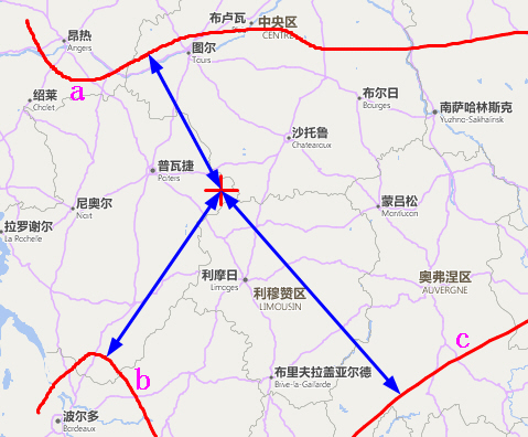
But this feature is nearest track to a center point.
See below, if I need only track a, b and c.
Thank you very much !


 I like this idea
Hello guys,
in the next version 3.36.0+ will be added "Sort by nearest" option. This calculates really precise distance to the nearest point on track so expect sorting little slower. For folders up to 100 tracks, this won't be a problem I believe. Enjoy it.
Hello guys,
in the next version 3.36.0+ will be added "Sort by nearest" option. This calculates really precise distance to the nearest point on track so expect sorting little slower. For folders up to 100 tracks, this won't be a problem I believe. Enjoy it.
Yes, we have "nearest points" and it will be good to have "nearest tracks".
Yes, we have "nearest points" and it will be good to have "nearest tracks".
Hi Menion, we chatted about that long time ago. I just checked the data model or tracks.db: LON and LAT are both indexed. You know the bounding box of the displayed area. So the SQL ... AND ... -statement needed is no miracle, right ?
The locations table can have 7 digit number of entries, I know, but with your indexing (Latid, Longit) that should not be a killer. Have you ever tried on an Android ?
Hi guys,
Michael, to be true, I did not tried it. I'll discuss this with Petr next week, he is more skilled with these databases systems then me.
Anyway meanwhile you should be able to use "Search screen > tracks". There is option to search for a tracks nearest to certain place (map center for example).
Can you pls. help me out, Menion. I installed 3.24 Pro this evening
But in the Tracks screen I do not see a search function. Going to general search, I see a track search that looks for a text pattern only. Next I look into nearest points - all options are checked, incl. track waypoints (but not "only visible"): nothing.
I have a visible track near the center and tons of invisible ones, too. At least their start and end points should appear, right ? Can you pls. advise ?
An additional idea to this topic: additional to start and end coordinates, you could define a calculated middle point of a track. And then you could optional find/sort tracks using this point.
For my use: I start and end very often at the same location, but I walk in different directions (the northern mountains, to the east hills, ...) and my walks are sometimes longer or shorter (afternoon walk or whole day hike). So, this middle point of the track is much more significant for sorting or finding tracks around a given location, than start and end point in this situation.
Hello guys,
in the next version 3.36.0+ will be added "Sort by nearest" option. This calculates really precise distance to the nearest point on track so expect sorting little slower. For folders up to 100 tracks, this won't be a problem I believe. Enjoy it.
Hello guys,
in the next version 3.36.0+ will be added "Sort by nearest" option. This calculates really precise distance to the nearest point on track so expect sorting little slower. For folders up to 100 tracks, this won't be a problem I believe. Enjoy it.
Perfect, thanks!
Locus Map <locus.map@asamm.com> schrieb am So., 13. Jän. 2019, 10:16:
Perfect, thanks!
Locus Map <locus.map@asamm.com> schrieb am So., 13. Jän. 2019, 10:16:
Replies have been locked on this page!