
This object is in archive!
Point Elements (Blog)
Answered
HI,
on your Blog "Silver or Classic? Take a look at the differences" I found this >> see attached drawing.
And in the frame such elements as: Difficulty, Terrain, Quality / DCVote (?)
and Logs.
I don't know what this is about, but these items are about (how? Where?) - and YOU CAN DO IT!
I am constantly fighting with you to get these elements also for the saved routes, with no luck.
What I saw is an extra solution and it should be about routes and waypoints.
Waldek
Files:
LM_Blog.jpg
 The same question
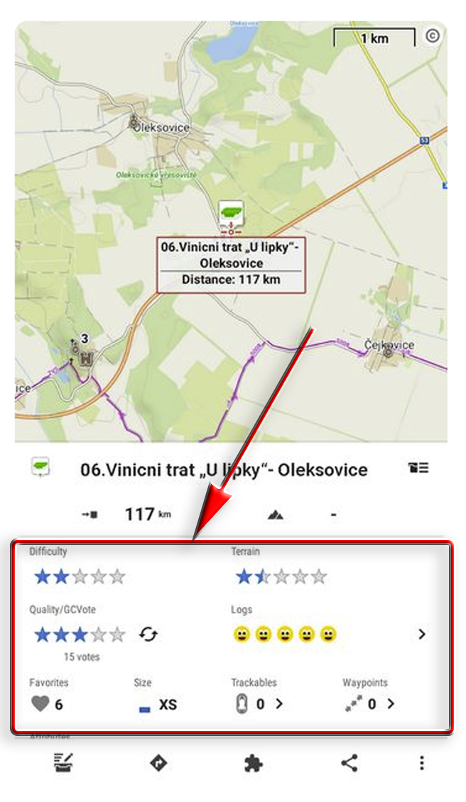
Hi Waldek,
this is a detail panel of a geocache, not of a route. More about geocaching: https://www.geocaching.com. More about geocaching features in Locus Map: https://docs.locusmap.app/doku.php?id=manual:user_guide:geocaching:gc_in_locus
Hi Waldek,
this is a detail panel of a geocache, not of a route. More about geocaching: https://www.geocaching.com. More about geocaching features in Locus Map: https://docs.locusmap.app/doku.php?id=manual:user_guide:geocaching:gc_in_locus
So you can for the box and not for the route and points.
You can adapt the same elements (those in the frame) to points and routes.
So you can for the box and not for the route and points.
You can adapt the same elements (those in the frame) to points and routes.
Difficulty and terrain (surface or way type) data are used in the route planner - the router renders the route from segments based on these parameters (plus more others). Tracks or routes in Locus database do not contain these data so it is not possible to sort or filter them according to them.
GC vote, logs, size, favourite, trackables, and waypoints are purely geocaching parameters in this context.
It was just an example.
e.g. a user for a route could have additional help in handling such scoring:
- The attractiveness of the route
- Difficulty level
e.t.c.
They are important to me, but I am currently unable to use them. I have to go through each route one by one and read its description.
There is no problem when these routes are few. But when I have about a hundred or more.So what solution in this regard, gentlemen, will you propose to me?
I must admit that geocaching is exemplary (filtering, sorting) compared to the solutions for routes and points. There is only poverty there.
It's simple - we don't have data of this kind. This data are also very subjective:
- the attractiveness of the route - how do you want to measure this objectively? Everybody has different tastes and preferences
- the difficulty level - the same as above analogically - Everybody has a different level of skill and physical power
rating from 1 to 5 stars
these will be the user's ratings for him.
So he will know what attractive routes are for him,
he will know what the difficult route is for him.
After all, he is the user of Locus, it will be for him.
He will see it.
rating from 1 to 5 stars
these will be the user's ratings for him.
So he will know what attractive routes are for him,
he will know what the difficult route is for him.
After all, he is the user of Locus, it will be for him.
He will see it.
All this would be possible only if the routes/tracks used in Locus by Locus users were made public (similarly to geocaches). So far, this is not possible at the moment. Each Locus user has his track/route database kept private. Maybe in the future we'll decide to create a public route browser, users will have the option to rate the tracks and routes by difficulty or favorability. Now it's not possible.
All this would be possible only if the routes/tracks used in Locus by Locus users were made public (similarly to geocaches). So far, this is not possible at the moment. Each Locus user has his track/route database kept private. Maybe in the future we'll decide to create a public route browser, users will have the option to rate the tracks and routes by difficulty or favorability. Now it's not possible.
Replies have been locked on this page!