
Track & route breaks the web planner
You (LM devs) may be interested in a combined track/ route in which you can see the displayed Slope is perfectly flat on top - weird!!
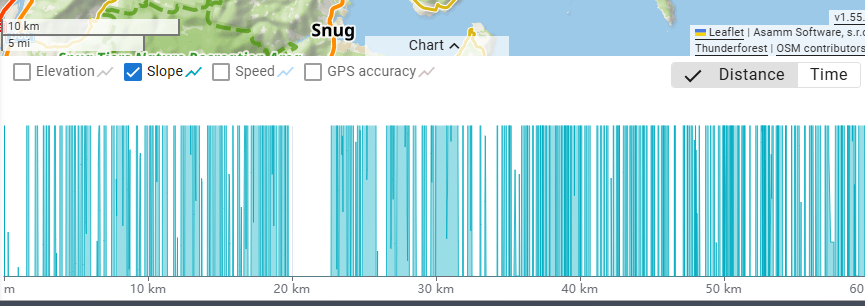
The first 35km is correct recorded track data. At this point I paused the recording. When I unpaused it an (approx.) hour later I forgot to disable battery saving, so there was no further track recording. BTW if there had been a message in satellite view like at the startup to remind me, I would have disabled battery saving, but I digress. After the end of the trip, and for the rest of the "track" I went into the LM4 Android route planner & fudged the track as a route so that the complete distance was accurate - better than nothing. BUT when I view this now combo zombie track/ route in the web planner it gets quite confused. There was even a time (can't reproduce) when the hover tooltip of the bottom chart "locked up" & wouldn't further respond or move. I just thought you may find the data of interest.
 The same problem
Hi Andrew,
interesting case... Forwarded to the devs.
Hi Andrew,
interesting case... Forwarded to the devs.
somewhat briefer summary: track recording + appended extra routing planning = weird result ;-)
somewhat briefer summary: track recording + appended extra routing planning = weird result ;-)
You no doubt already know the issue, as the Web Planner v1.55.5 says "Route chart: Fixed slope percentage calculation crash", although I see no change to the chart yet. When I view the GPX file in Garmin Basecamp it is clearly evident that the last recorded track point has a valid timestamp 30/4/2025 11:21AM and the additional/ appended route planner track points commence at 1/1/1970 11AM. What should be expected in this case? I don't know. Continue timestamps after the last? But if the route were extended before the starting point, or somewhere along the existing track, what expect then?
You no doubt already know the issue, as the Web Planner v1.55.5 says "Route chart: Fixed slope percentage calculation crash", although I see no change to the chart yet. When I view the GPX file in Garmin Basecamp it is clearly evident that the last recorded track point has a valid timestamp 30/4/2025 11:21AM and the additional/ appended route planner track points commence at 1/1/1970 11AM. What should be expected in this case? I don't know. Continue timestamps after the last? But if the route were extended before the starting point, or somewhere along the existing track, what expect then?
Hi Andrew,
finally, we managed to identify the cause of the problem and we fixed it, but so far, in the "dev" branch only. The fix will come to the production level next week.
Hi Andrew,
finally, we managed to identify the cause of the problem and we fixed it, but so far, in the "dev" branch only. The fix will come to the production level next week.
Replies have been locked on this page!