
Just switched from lotus classic and got a subscription. I've stuck to the old version because I didn't like the "4" when it was launched.
I've now decided to give it a go.
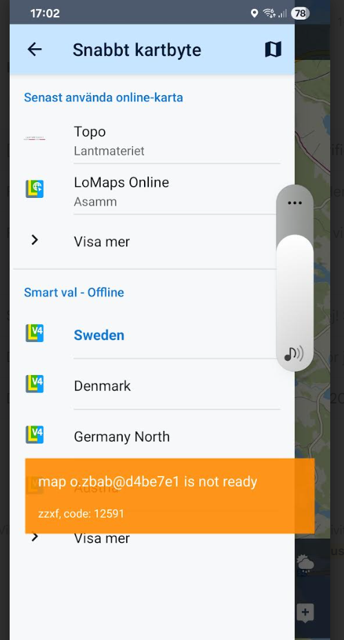
My problem is this. The Swedish "lantmäterikarta" is the only one I use. And as toy can se on the attached screenshot it doesn't work.
 The same problem
Får detta på både svenska och norska kartan när jag försöker öppna/visa dom.
Får detta på både svenska och norska kartan när jag försöker öppna/visa dom.
Hi Sven,
we are sorry for the inconvenience but both publishers have recently changed their API for connecting third party apps to their databases, both without any notification. We have fixed the Statkart maps - you can test it in our latest beta version available at https://bit.ly/lmVersionsTest.
We're still working on Lantmateriet though which seems to be more complicated.
Thanks for understanding.
Please inform when you have solved the problem.
As of now I can't use your app.
I will check statkart.
Br
Sven K
Please inform when you have solved the problem.
As of now I can't use your app.
I will check statkart.
Br
Sven K
The are also LoMaps covering the area of Sweden so for the time being you may use them. At the moment, we are awaiting a reply from Lantmateriet about technical and business details of their new solution.
The are also LoMaps covering the area of Sweden so for the time being you may use them. At the moment, we are awaiting a reply from Lantmateriet about technical and business details of their new solution.
Hi
The quality of the Locus maps are quite inferior. I.e. I can't really use them for hiking, MTB and scating tripps.
I do this in both Norway and Sweden. Please compare Locus maps with apps "Min karta" and "Norgeskart".
Preferable while you are at it please make it possible to download much bigger areas such as half off Sweden and half of Norway
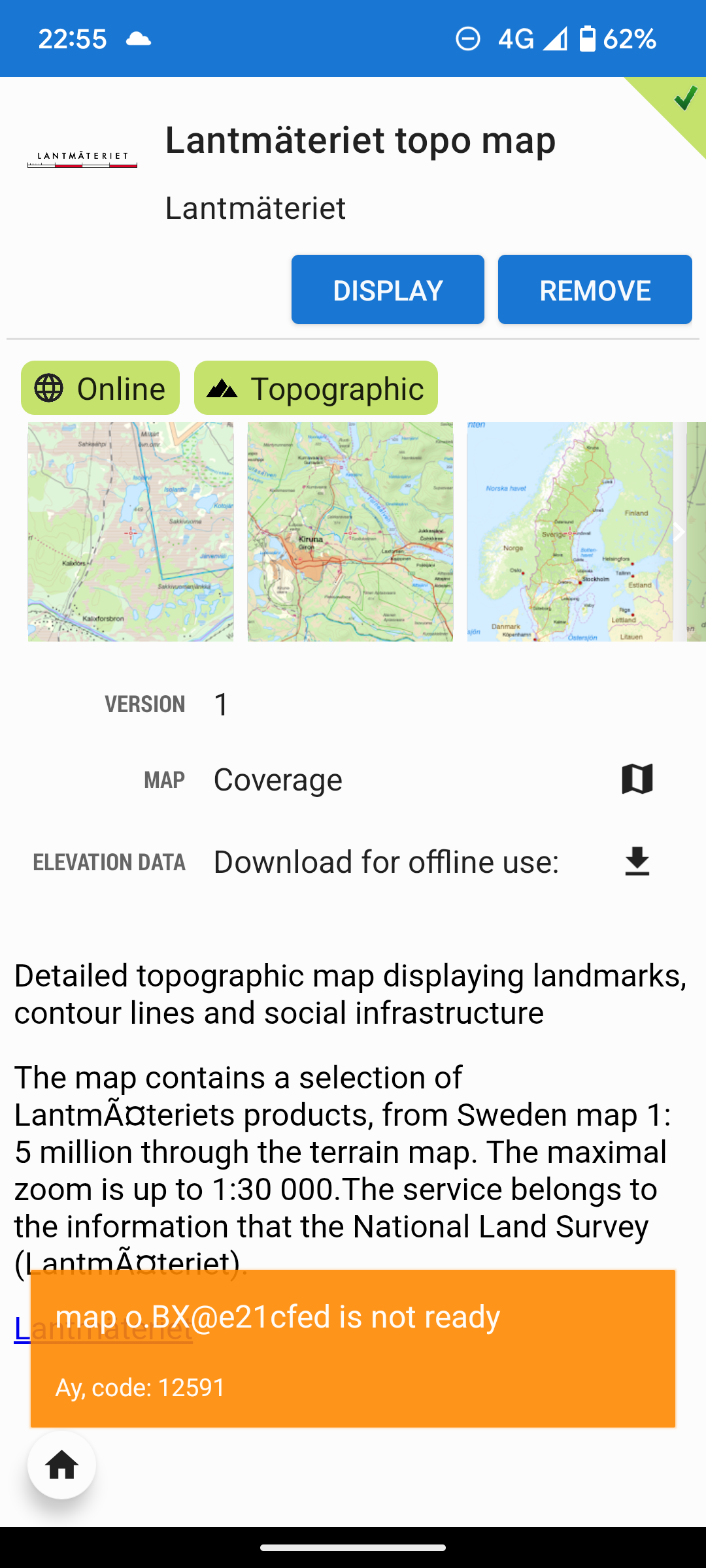
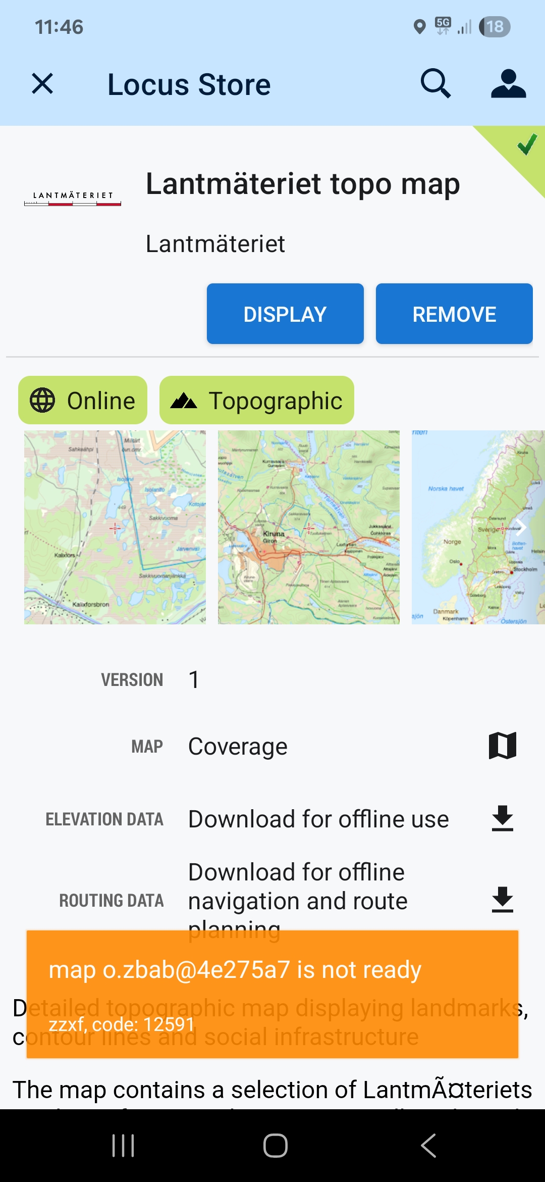
I am experiencing an issue with the Lantmäteriet Topo Map, Sweden layer, it is not loading as expected. The system returns error code 12591. Please see the attached files for reference.
I am experiencing an issue with the Lantmäteriet Topo Map, Sweden layer, it is not loading as expected. The system returns error code 12591. Please see the attached files for reference.
Hi Anders,
yes, we've registered the issue and have been solving it - we are waiting for response from Lantmateriet which changed their API and terms of use for their maps. We asked them fo cooperation but so far, no response. It's been more than a week now. Sorry for the inconvenience.
regards
Michal, Locus team
Great that you are trying! Keep upp the good work Locus team! I hope you can solve it so I can keep using Locus Map, been using it for many years now and I really like your app👍 Lantmäteriet map is crucial for me and I need it so without it I will be forced to change map app. I also use Statkart when in Norway. Looking forward for good news regarding this issue soon. I really miss the Locus/Lantmäteriet functionality on our week long packrafting trip we are out on now. BR August, Sweden
Great that you are trying! Keep upp the good work Locus team! I hope you can solve it so I can keep using Locus Map, been using it for many years now and I really like your app👍 Lantmäteriet map is crucial for me and I need it so without it I will be forced to change map app. I also use Statkart when in Norway. Looking forward for good news regarding this issue soon. I really miss the Locus/Lantmäteriet functionality on our week long packrafting trip we are out on now. BR August, Sweden
Just switched from lotus classic and got a subscription. I've stuck to the old version because I didn't like the "4" when it was launched.
I've now decided to give it a go.
My problem is this. The Swedish "lantmäterikarta" is the only one I use. And as toy can se on the attached screenshot it doesn't work.
Hi all,
we have finally received a reply from Läntmateriet:
- their old map providing service was terminated on 28/5/2025
- they started a new map portal "Geotorget" into which we immediately registered
- they answered that they thank us for registration and informed us that our request will be manually evaluated. And because the are very busy these days, our request will be on standby for 1-2 weeks.
Hallo, do you have any news regarding the problem with the Swedish Lantmäteriet map.
Den fre 6 juni 2025 17:15Locus Map <locus.map@asamm.com> skrev:
I've now installed the beta version 4.29.0.11. Statkart.no works perfectly with it. Thank you for the great service.
Hallo, do you have any news regarding the problem with the Swedish Lantmäteriet map.
Den fre 6 juni 2025 17:15Locus Map <locus.map@asamm.com> skrev:
I've now installed the beta version 4.29.0.11. Statkart.no works perfectly with it. Thank you for the great service.
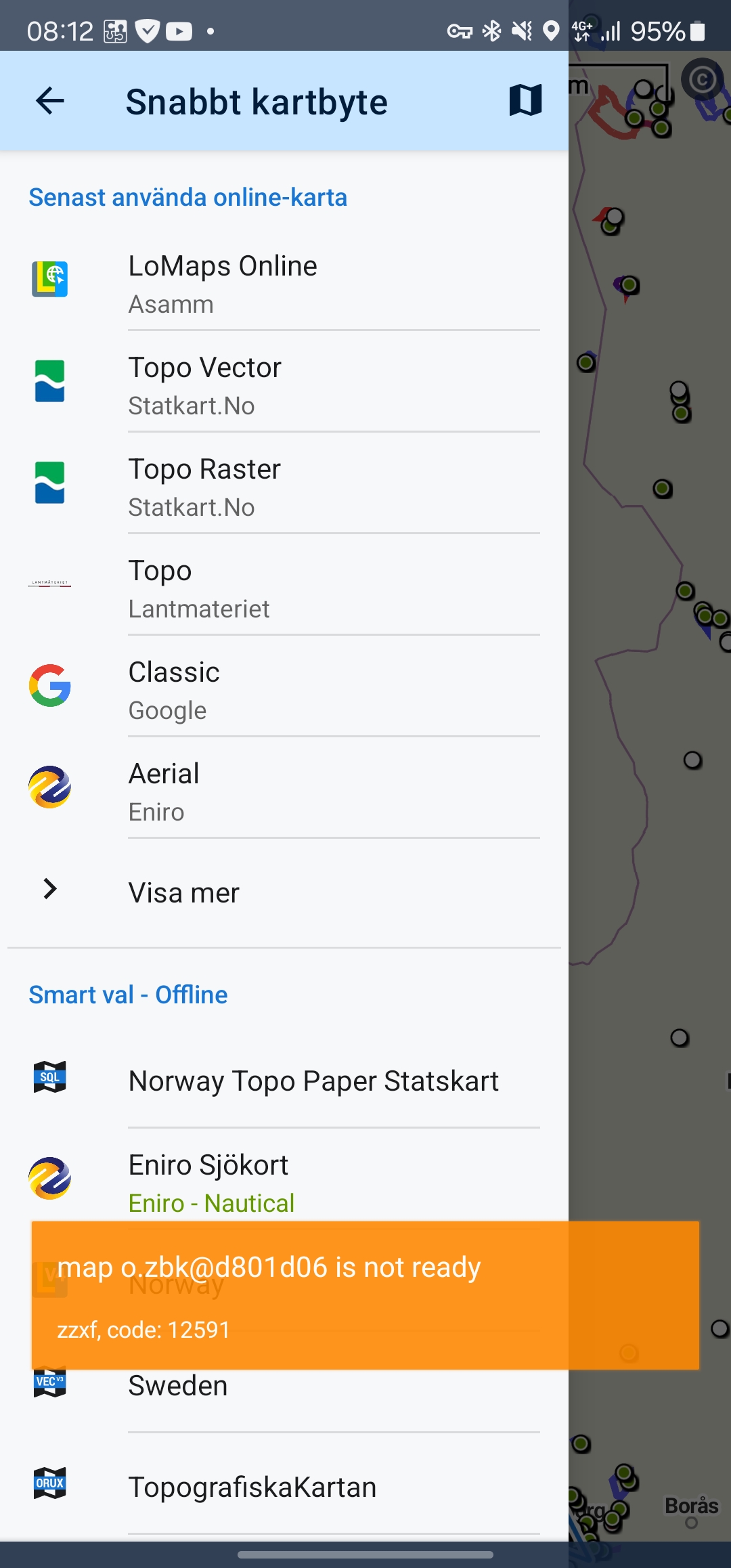
Hello
I cant open Swedish maps "lantmäteriet topo" . Excellent map for Sweden. It had worked. Picture shown error code
Hello
I cant open Swedish maps "lantmäteriet topo" . Excellent map for Sweden. It had worked. Picture shown error code
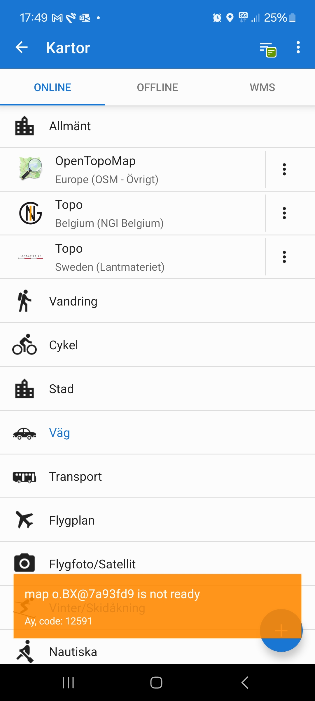
Hi
Previously I have been able to switch maps between Sweden (Locus offline) and Lantmateriet Topo. For some time now the attached image has been appearing when I try to switch maps to Lantmateriet Topo.
What is the error?
Best regards
Henry Westerberg
Hi
Previously I have been able to switch maps between Sweden (Locus offline) and Lantmateriet Topo. For some time now the attached image has been appearing when I try to switch maps to Lantmateriet Topo.
What is the error?
Best regards
Henry Westerberg
Hi everyone,
as we have informed, Lantmäteriet terminated its original free map service on 28/5/2025 and started a new map portal Geotorget. We registered to the portal immediately and after a few days received a reply that our registration is being evaluated and will be confirmed in a few weeks. Unfortunately, we still haven't received the confirmation nor any other information regarding using Lantmäteriet maps in our apps. Therefore, we are temporarily removing the map from Locus Map portfolio, beginning with the next app version 4.30, coming up next week. We are very sorry for this regrettable situation but it is not our fault.
I tried to create an account in Geoportalen Lantmäteriet and order an API key for the TOPO map. I received the WMTS address via automatic email. If it's possible to create a custom XML file with a personal API key, then everyone could create their own. I'm thinking you could create an XML template, and people would just paste in their own API key. If you have an email address, I can send over the WMTS address if you'd like to test it.
I tried to create an account in Geoportalen Lantmäteriet and order an API key for the TOPO map. I received the WMTS address via automatic email. If it's possible to create a custom XML file with a personal API key, then everyone could create their own. I'm thinking you could create an XML template, and people would just paste in their own API key. If you have an email address, I can send over the WMTS address if you'd like to test it.
The Swedish app Naturkartan has Lantmäteriet’s map, and it works just as expected, so presumably it is possible for third party apps to use the new API from Lantmäteriet. (There is also the app My map, but that is Lantmäteriet’s own map.)
The Swedish app Naturkartan has Lantmäteriet’s map, and it works just as expected, so presumably it is possible for third party apps to use the new API from Lantmäteriet. (There is also the app My map, but that is Lantmäteriet’s own map.)
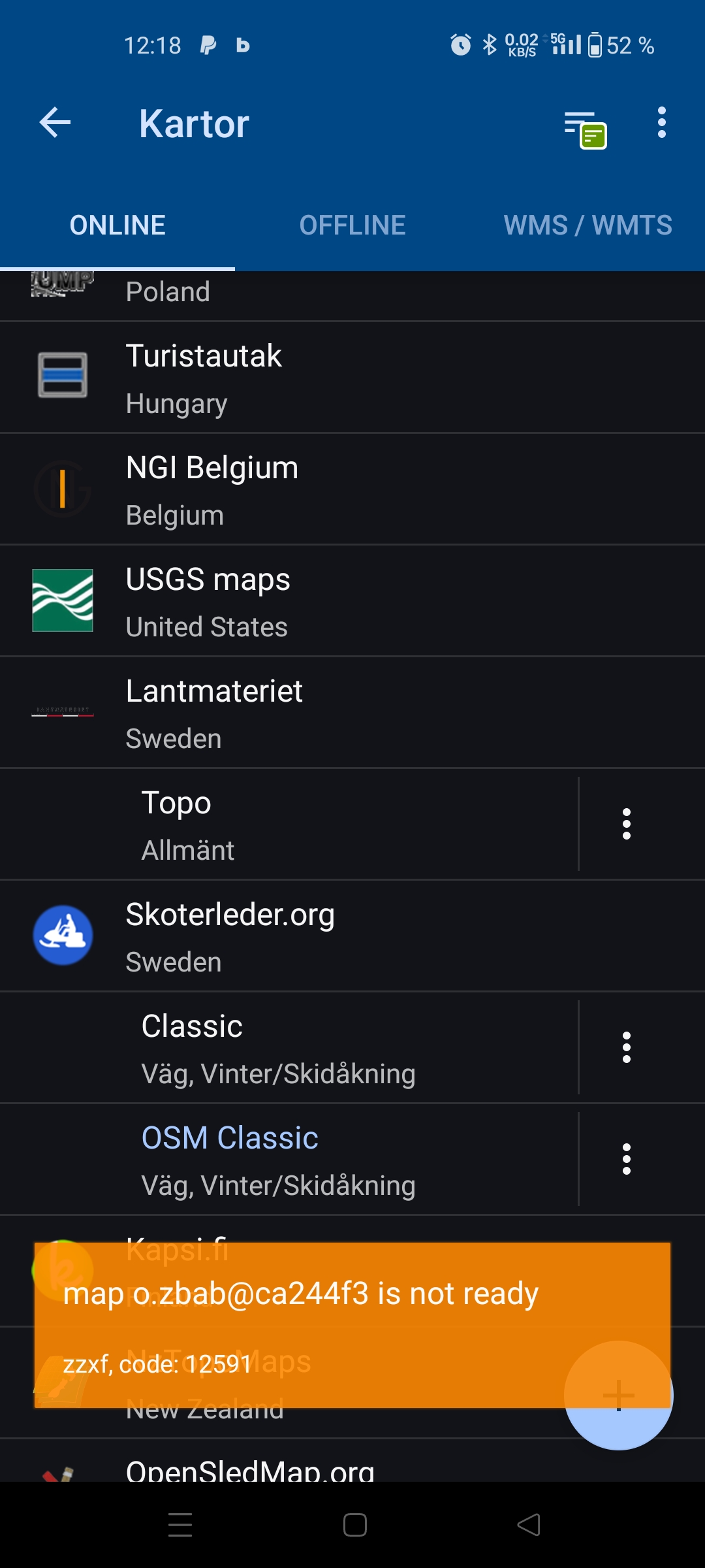
Hi!
Since a few weeks at least I have been unable to use the Lantmäteriet topo map plugin.
See attached photo for error.
The issue exists with both Locus Maps 3 and 4.
I’m wondering if this plugins is developed by Locus or if there is an external developer to notify about this issue?
I found this article about the open wms changing and if wms is being used as source, the data source must be changed. Although the article being in swedish I hope it is readable.
Ändrad åtkomst för vissa Öppna dataprodukter
lantmateriet.se
There is a free version available as WMTS. I tried it in Locus as WMTS with username and password, and it works fine. The map is under CC0 (See attached file).
Translated, it means: The license means you can use, distribute, adapt, modify, and build upon Lantmäteriet's open data, even in commercial contexts, without any restrictions. Please attribute Lantmäteriet as the source when you distribute our open data, but it's not a requirement.
To access the map, you create an account and click 'order'. The order will automatically be delivered to your account in a couple of seconds.
https://geotorget.lantmateriet.se/geodataprodukter/topografisk-webbkarta-visning-oversiktlig-api
This service should be fine to use. Please let me know if you need help from anyone on the Swedish side. In the meantime, thankyou for a very good app.
Hi,
Lantmateriet maps have been added back to the app. Please update to the latest version 4.31.3.
Hi,
Lantmateriet maps have been added back to the app. Please update to the latest version 4.31.3.
If I search in Locus Store I see "Lantmäteriet Sweden maps" but if I then select this search result it says "No data to display here".
If I search in Locus Store I see "Lantmäteriet Sweden maps" but if I then select this search result it says "No data to display here".
On my old device that had lantmäteriet maps before they are back after last update but on my new phone with same version there is no map to find . I can find "lantmäteriet" but If I click on it "no data to find"
On my old device that had lantmäteriet maps before they are back after last update but on my new phone with same version there is no map to find . I can find "lantmäteriet" but If I click on it "no data to find"
Hi all,
the Lantmateriet map is available in Locus Map 4 > map manager > online tab. If you don't see it there, check the "available maps" in the topbar menu.
The Lantmateriet map is not available in Locus Map Classic yet - we are expecting a new app version in a few days and the devs promised to restore the map there as well.
The Lantmateriet map is not available in Locus Store at the moment. This will have to be dealt with. - fixed
I don't know I you done something but now I could install the swedish lantmäteriet topo map. 👍
I don't know I you done something but now I could install the swedish lantmäteriet topo map. 👍
If anybody has a problem with downloading the map, please install the latest beta version from our public repo at https://bit.ly/lmVersionsTest
If anybody has a problem with downloading the map, please install the latest beta version from our public repo at https://bit.ly/lmVersionsTest
Replies have been locked on this page!