


LoMaps detail and lower zoom level on Android
Hi!
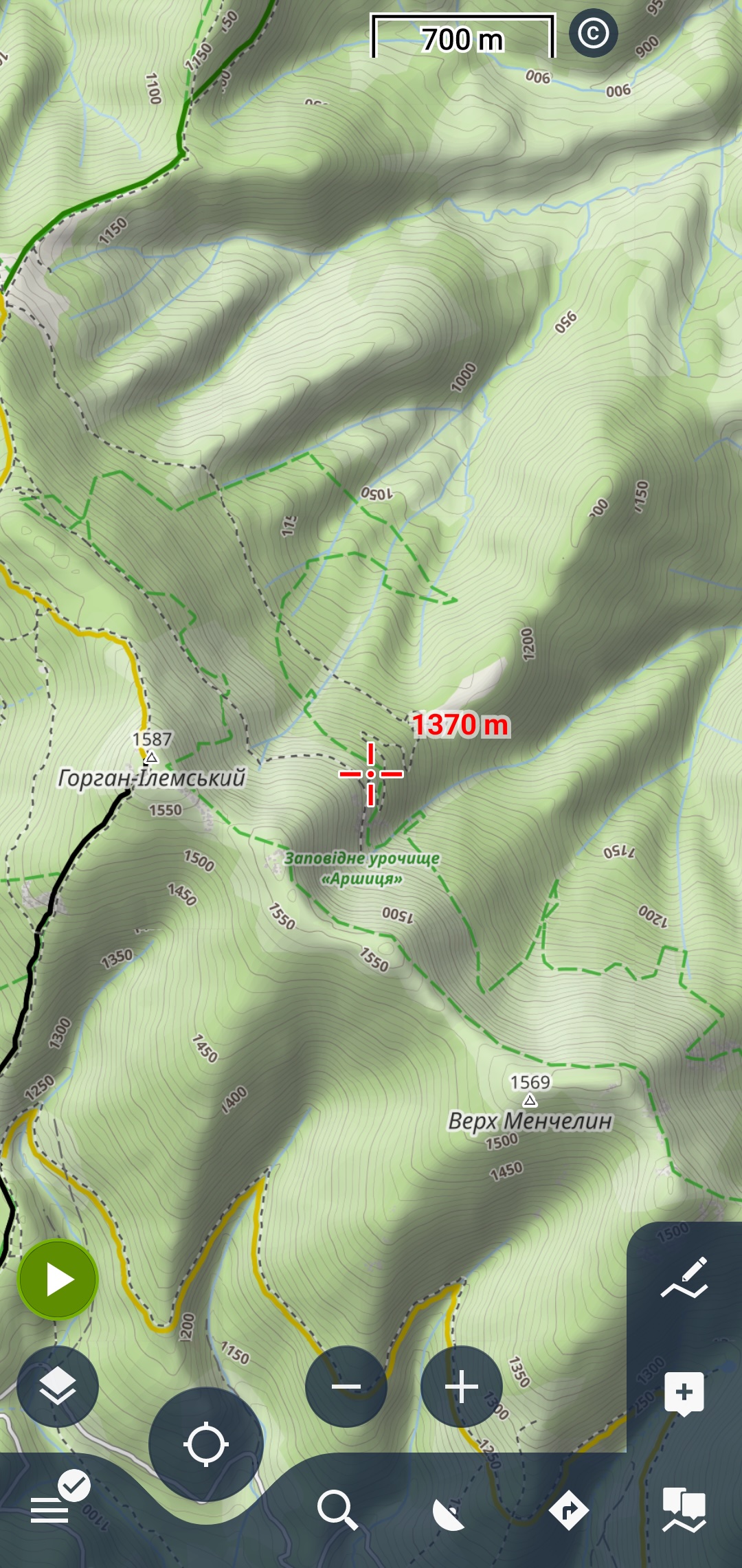
Could you please advise if there's any setting in Android LoMaps that would allow map features such as peak names, rivers, protected areas, etc. to be displayed at lower zoom levels? Right now I need to zoom in to around the 700 m scale (at least) before I start seeing most names. On a phone screen that doesn't make for a very smooth experience, as I lose a lot of context when zooming.
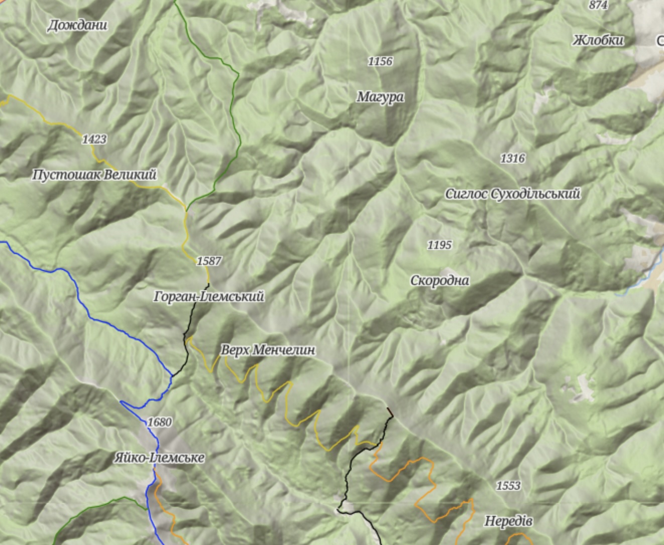
In the Locus web app, some peak names are already visible around the 2000 m scale. It's not always perfect (sometimes a lower peak is labeled while a higher nearby one isn't), but having that additional information visible from further out is much more usable. Is it possible to get similar UX on Android LoMaps somehow?
I have attached example schreenshots (LoMaps Android at 2km and 700m scale, and LoMaps web at 2000m scale). I'm happy to provide other information if that helps.
I don't think it's related to the specific area - for example, in Iceland, where there's a lot of wilderness, but peaks/glaciers etc have names, you just scroll through "unnamed" "blank" areas, making exploration experience really strange and not natural on mobile.
 The same question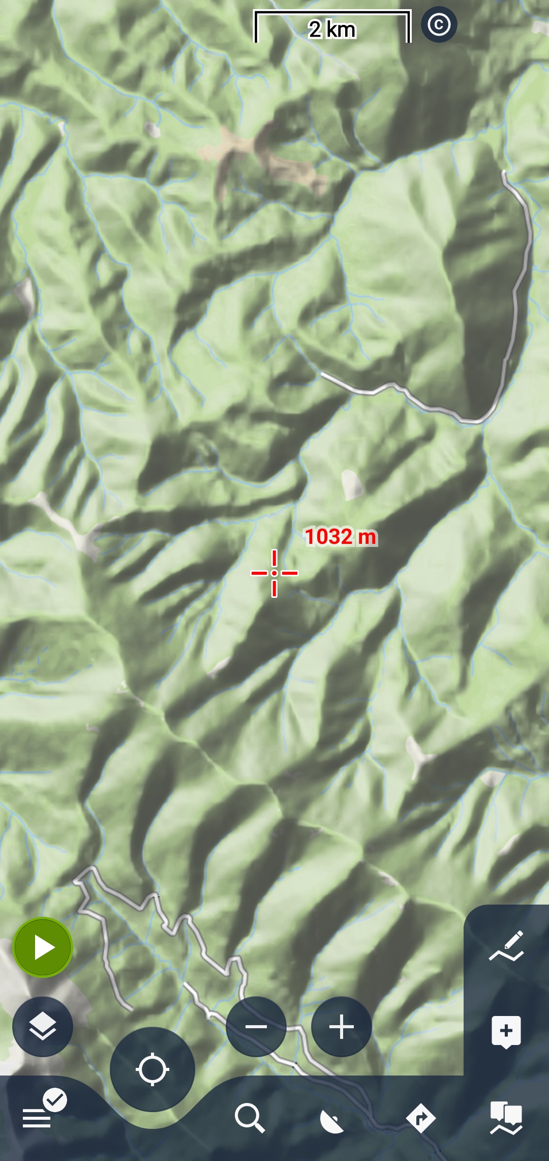
Have a look at OAM World Maps - you can use them as default maps for lower zoom levels (up to ZL 8, 9, 10 or 11 for the whole planet). And the ZL12 or 13 Regional Map should help a bit for your purpose: https://www.openandromaps.org/en/downloads/general-maps
Cheers
Michael
Have a look at OAM World Maps - you can use them as default maps for lower zoom levels (up to ZL 8, 9, 10 or 11 for the whole planet). And the ZL12 or 13 Regional Map should help a bit for your purpose: https://www.openandromaps.org/en/downloads/general-maps
Cheers
Michael
Hi Mariusz,
I think I can say that we’re planning to bring the web version of online LoMaps to Android next month, so the results should be noticeably better.
In the meantime, I recommend using the search feature (for example, searching for peaks) or highlighting the Peaks category directly on the map. You can find a short guide here: https://docs.locusmap.app/doku.php/manual:user_guide:points:locus_maps_pois#highlighting_on_map
Petr, Locus team
Hi Mariusz,
I think I can say that we’re planning to bring the web version of online LoMaps to Android next month, so the results should be noticeably better.
In the meantime, I recommend using the search feature (for example, searching for peaks) or highlighting the Peaks category directly on the map. You can find a short guide here: https://docs.locusmap.app/doku.php/manual:user_guide:points:locus_maps_pois#highlighting_on_map
Petr, Locus team
Hi Petr, thank you for the answer, but you are answering to Mariuz - so probably wrong thread, and I can't really tell if that really answers my question. Anyway, my question isn't about Web/online maps - my question is about improving appearance of LoMaps in Android application. I know about search, but it's really not the same - it assumes you know the area and look for a specific thing. When planning and/or exploring, it just doesn't work that way...
Using highlight doesn't solve the issue either - you will have highlighted locations of the peaks, sure, but not the actual names (please see the attachment).
So it feels rather strange - at low level zoom (before 700m), it feels like you scroll through very low quality map without anything but major cities/villages (and if there are none - you just guess where you are). No peaks, no rivers. If you zoom in to 700m scale, you do see peaks, but then it's like scrutinizing the area under microscope. You just can't get something in the middle..
Hi Petr, thank you for the answer, but you are answering to Mariuz - so probably wrong thread, and I can't really tell if that really answers my question. Anyway, my question isn't about Web/online maps - my question is about improving appearance of LoMaps in Android application. I know about search, but it's really not the same - it assumes you know the area and look for a specific thing. When planning and/or exploring, it just doesn't work that way...
Using highlight doesn't solve the issue either - you will have highlighted locations of the peaks, sure, but not the actual names (please see the attachment).
So it feels rather strange - at low level zoom (before 700m), it feels like you scroll through very low quality map without anything but major cities/villages (and if there are none - you just guess where you are). No peaks, no rivers. If you zoom in to 700m scale, you do see peaks, but then it's like scrutinizing the area under microscope. You just can't get something in the middle..
Hi Sasha,
thank you for your message. And sorry for the name mix‑up in my previous reply - that was my mistake but, the answer was indeed meant for you.
Regarding the maps: the current Android Online LoMaps are not fully under our control, and some changes are technically not possible in this version. As mentioned, we’re planning to bring the new Online LoMaps to Android in the coming months, which should significantly improve the situation.
In the meantime, you can try offline LoMaps, which generally provide better results. (Menu > Maps > Offline > PLUS > Download maps > and search for country/state you're interested in)
Regards Petr
Hi Sasha,
thank you for your message. And sorry for the name mix‑up in my previous reply - that was my mistake but, the answer was indeed meant for you.
Regarding the maps: the current Android Online LoMaps are not fully under our control, and some changes are technically not possible in this version. As mentioned, we’re planning to bring the new Online LoMaps to Android in the coming months, which should significantly improve the situation.
In the meantime, you can try offline LoMaps, which generally provide better results. (Menu > Maps > Offline > PLUS > Download maps > and search for country/state you're interested in)
Regards Petr
Hi Petr, thank you for the answer and the insights! Indeed offline LoMaps seem to work better in that regard - I would still hope for a bit more details sometimes, but generally it's obvious improvement for my workflow.
And just to double check - while we are here - offline maps appearance is not configurable in terms of details as well, right? I mean, I can't tell offline maps to show mid-size or small-size villages (or even simply more details in general) if I'm at scale of, say, 1:5km or 1:10km, is that correct? I guess probably no, but one could dream to have missed some setting, eh? :)
Hi Petr, thank you for the answer and the insights! Indeed offline LoMaps seem to work better in that regard - I would still hope for a bit more details sometimes, but generally it's obvious improvement for my workflow.
And just to double check - while we are here - offline maps appearance is not configurable in terms of details as well, right? I mean, I can't tell offline maps to show mid-size or small-size villages (or even simply more details in general) if I'm at scale of, say, 1:5km or 1:10km, is that correct? I guess probably no, but one could dream to have missed some setting, eh? :)
Have a look at OAM World Maps - you can use them as default maps for lower zoom levels (up to ZL 8, 9, 10 or 11 for the whole planet). And the ZL12 or 13 Regional Map should help a bit for your purpose: https://www.openandromaps.org/en/downloads/general-maps
Cheers
Michael
Have a look at OAM World Maps - you can use them as default maps for lower zoom levels (up to ZL 8, 9, 10 or 11 for the whole planet). And the ZL12 or 13 Regional Map should help a bit for your purpose: https://www.openandromaps.org/en/downloads/general-maps
Cheers
Michael
Hi Michael, thank you for the suggestion - I've tried to download those for my country, but there's not much difference to offline LoMaps (unless I missed something) - more or less same villages/peaks are displayed/hidden at the same zoom levels. There was a bit of the difference for the protected area highlight, which is appreciated. At the same time, they had their own issues (like attached). Maybe it's some specific of regional map and I'm yet to try out whole planet general map - once I manage to have enough storage for it.
Hi Michael, thank you for the suggestion - I've tried to download those for my country, but there's not much difference to offline LoMaps (unless I missed something) - more or less same villages/peaks are displayed/hidden at the same zoom levels. There was a bit of the difference for the protected area highlight, which is appreciated. At the same time, they had their own issues (like attached). Maybe it's some specific of regional map and I'm yet to try out whole planet general map - once I manage to have enough storage for it.
Hello Sacha, both attached are really very similar - BUT none of the two shows OAM World maps. OAM Word Maps (and vector maps, too) control the appearance per zoom level based on peak's dominance, BTW.
Hello Sacha, both attached are really very similar - BUT none of the two shows OAM World maps. OAM Word Maps (and vector maps, too) control the appearance per zoom level based on peak's dominance, BTW.
I got them at https://www.openandromaps.org/en/downloads/europe via Locus installer for Ukraine - maybe it's a different map. Let me check the general maps once I have storage cleaned up and hopefully it's different. Control of the appearance per zoom level based on peak's dominance sounds like what I'm looking for :)
I got them at https://www.openandromaps.org/en/downloads/europe via Locus installer for Ukraine - maybe it's a different map. Let me check the general maps once I have storage cleaned up and hopefully it's different. Control of the appearance per zoom level based on peak's dominance sounds like what I'm looking for :)
that is a vector map, not a prerendered world map.
to use the Ukraine map properly you need a valid theme from OAM, too. elevate or elements, also one click download from OAM website
that is a vector map, not a prerendered world map.
to use the Ukraine map properly you need a valid theme from OAM, too. elevate or elements, also one click download from OAM website
Hi Michael, I played a bit with it - my two latest screenshots were with Locus's own Hiking built-in theme. Once I installed Elevate, the appearance completely changed and I think that is what I was looking for. Obviously, colors are a bit different (reminiscent of the paper maps I used at some point, or the maps I use for my Garmin watch - that's different to LoMaps, but looks good too), marked paths color coding approach is different, but in general that's a significant improvement for my process. Thank you a lot!
Hi Michael, I played a bit with it - my two latest screenshots were with Locus's own Hiking built-in theme. Once I installed Elevate, the appearance completely changed and I think that is what I was looking for. Obviously, colors are a bit different (reminiscent of the paper maps I used at some point, or the maps I use for my Garmin watch - that's different to LoMaps, but looks good too), marked paths color coding approach is different, but in general that's a significant improvement for my process. Thank you a lot!
Replies have been locked on this page!