This object is in archive! 

Custom URL opening

Martin shared this idea 8 years ago
Completed

Hi,


i got this idea from GSAK - Geocaching Waypoint Software for Windows.

In GSAK you can have a List of Custom URLs, which you can open for your specific waypoints.


These waypoints have variables for e.g. Latitude and Longitude, so the URL for every waypoint is different.


There are a lot of usefull cases, like


Bing Maps (Sat)=http://www.bing.com/maps/?v=2&cp=%lat~%lon&sp=aN.%lat_%lon_%name&lvl=18&dir=0&sty=h&form=LMLTCC


Flickr=http://www.flickr.com/map?&fLat=%lat&fLon=%lon&zl=9


Guidemate=http://guidemate.com/tours?lat=%lat&lng=%lon&zoom=13


MapQuest=http://www.mapquest.com/maps/map.adp?latlongtype=decimal&latitude=%lat&longitude=%lon


Nearby.org.uk=http://www.nearby.org.uk/google/?lat=%lat&long=%lon&zoom=1&layers=


OSM.org=http://www.openstreetmap.org/?mlat=%lat&mlon=%lon&zoom=17


Panoramio=http://www.panoramio.com/map/#lt=%lat=D&ln=%lon=D&z=-1&k=2


WheelMap=http://wheelmap.org/?zoom=18&lat=%lat=D&lon=%Lon=D&layers=BT


(...)


Is there a way to integrate a list of these URLs to Locus?

Best Answer

Replies (10)

photo
1

Wow, this looks nice! Ill try it.


Thanks!

photo
1

Hello Martin and gynta,


yes I also think that "Quick bookmarks" is exactly what you are looking for.


Btw. don't you mind if any of your links above, will be added into internal list of recommended bookmarks directly inside this function? Thanks

photo
1

Would it be possible to share added custom URL's associated to a POI's with a broader community?

photo
1

There are currently just four web sites inside apps that you may add directly. That's why I asked Martin. So currently there is no system how to share URL with others directly over app, anyway I would really like to add some nice web sites directly into Locus into "Favorites (available when you add new bookmark > star icon at top)". So suggestions are welcome.


Hope I've answered on your question.

photo
1

Feel free to use my url - I have a lot of them.


I will post them here if you want.

photo
1

Thanks Martin, appreciate it. @Michal, may you please check and choose interesting links that may be added directly into Locus next to already existing four "favorites"? Thanks

photo
1

I tested all except OSM.org as we have their maps in many versions in our portfolio. Flickr, Bing, Guidemate and Wheelmap can be succesfully added to Locus via the Quick bookmark feature. Mapquest online won't work but we have this map by default. Panoramio doesn't cooperate for some unknown reason and Nearby.org.uk either.

photo
1

Thanks Michal. I expect they works when Martin use them. But I wanted to know, which of them are interested enough, to add them directly to Locus as suggested, predefined, services. We do not want to overwhelm users right? :)

photo
1

My list:


Benchmarks=http://www.geocaching.com/mark/nearest.aspx?


Geocaching Map (MapQuest/Google Maps)=http://www.geocaching.com/map/?ll=%lat,%lon&z=20


Wegpunkt-Umrechnung=http://www.geocaching.com/wpt/?lat=%lat&lon=%lon&detail=1


Administrative Karte=http://openmapsurfer.uni-hd.de/?lat=%lat&lon=%lon&zoom=13&layers=B000000

bergfex=http://www.bergfex.at/?mapstate=%lat,%lon,13,p,180&f=1

Bing Maps (Sat)=http://www.bing.com/maps/?v=2&cp=%lat~%lon&sp=aN.%lat_%lon_%name&lvl=18&dir=0&sty=h&form=LMLTCC

Bing Maps (Vogel)=http://www.bing.com/maps/?v=2&cp=%lat~%lon&sp=aN.%lat_%lon_%name&lvl=17&dir=0&sty=b&form=LMLTCC

Brewpubs=http://brewpubs.openstreetmap.de/?zoom=12&lat=%lat&lon=%lon&layers=BT

Braunschweig=http://www.braunschweig.de/plan/#lm=%lat/%lon&lml=%code%20(%name)

Cloudmade=http://maps.cloudmade.com/?lat=%lat&lng=%lon&zoom=15&styleId=1&opened_tab=0

Confluence=http://www.confluence.org/confluence.php?lat=%lat&lon=%lon

EFA (nach)=http://www.efa.de/gvh/XSLT_TRIP_REQUEST2?language=de&name_destination=%lon:%lat:WGS84[DD.ddddd]:Koordinate&type_destination=coord&sessionID=0&itdLPxx_extLogo=efaportal

EFA (von)=http://www.efa.de/gvh/XSLT_TRIP_REQUEST2?language=de&name_origin=%lon:%lat:WGS84[DD.ddddd]:Koordinate&type_origin=coord&sessionID=0&itdLPxx_extLogo=efaportal

Eniro Map=http://kartor.eniro.se/query?&what=map&imgmode=0&mapstate=15;%lon;%lat

Eniro Sat=http://kartor.eniro.se/query?&what=map&imgmode=1&mapstate=15;%lon;%lat

Eniro Hybrid=http://kartor.eniro.se/query?&what=map&imgmode=2&mapstate=15;%lon;%lat

Eniro See=http://kartor.eniro.se/query?&what=map&imgmode=4&mapstate=10;%lon;%lat

Eniro Maps HHL=http://kartor.eniro.se/query?what=map&mapstate=15;%lon;%lat

Eniro Print Aerial=http://kartor.eniro.se/print?profile=se&mapType=aerial¢er=%lat,%lon&zoom=15

Eniro Print Hybrid=http://kartor.eniro.se/print?profile=se&mapType=hybrid¢er=%lat,%lon&zoom=15

Eniro Print Map=http://kartor.eniro.se/print?profile=se&mapType=map¢er=%lat,%lon&zoom=15

Flickr=http://www.flickr.com/map?&fLat=%lat&fLon=%lon&zl=9

Flopp=http://foomap.de/?c=%lat:%lon&z=14&t=OSM&m=A:%lat:%lon:161

Freie Tonne=http://www.freietonne.de/seekarte/?lon=%lon&lat=%lat

Geocaching.com-Suche=http://www.geocaching.com/seek/nearest.aspx?lat=%lat&lon=%lon

Geofabrik=http://tools.geofabrik.de/osmi/?view=geometry&lon=%lon&lat=%lat&zoom=12

Google\Google Earth=http://www.nearby.org.uk/googleEarth.kml.php?lat=%lat&long=%lon&zoom=1&p=%code

Google\Google Kalender=https://www.google.com/calendar/render?action=TEMPLATE&text=%name+%28%typ%29&details=http://coord.info/%code+%typ&location=%lat,%lon

Google\Google MapMaker=http://www.google.de/mapmaker?ll=%lat,%lon&spn=0.016939,0.044932&z=15&lyt=large_map

Google\Google Maps=http://maps.google.com/maps?q=%lat+%lon+(%code-%name)&hl=de

Google\!Google Maps (Karte)=https://maps.google.com/maps?q=%lat+%lon+(%code-%name)&hl=de&t=m&z=15

Google\Google Maps (Sat)=https://maps.google.com/maps?q=%lat+%lon+(%code-%name)&hl=de&t=h&z=15

Google\Google Maps (Karte) (Wetter)=https://maps.google.com/maps?ll=%lat,%lon&spn=0.02024,0.038581&t=m&z=15&lci=weather

Google\Google Maps Route=https://maps.google.com/maps?f=d&saddr=52.256361,10.508531+%28Heimatkoordinaten%29&daddr=%lat,%lon+%28%name%29

GPSGames=http://geocaching.gpsgames.org/cgi-bin/ge.pl?caches=yes&fromlat=%lat&fromlon=%lon

GSAK Polygon=http://gsak.net/google/polygoneditor.html?minlat=52.19405&minlon=10.430167&maxlat=52.344633&maxlon=10.6253

Guidemate=http://guidemate.com/tours?lat=%lat&lng=%lon&zoom=13

Harzer Wandernadel=http://fam-tille.de/hwn/?zoom=16&lat=%lat&lon=%lon&layers=B00TFFTT

!iD=http://www.openstreetmap.org/edit?editor=id#map=17/%lat/%lon

Ingress Map=http://www.ingress.com/intel?%macro="LatLonNoSeparator.gsk"&z=14

Lacita=http://www.lacita.org/cgi_bin/bf.pl?Path=00&lat=%lat&lng=%lon&z=13

Logbuch=http://www.gctoolbox.de/tools/genlog/createpdf.php?name=%name&nummer=%code&owner=%ownerName&color=FFFFFF&comment=1&image=http://gctoolbox.de/img/logico.PNG&colorb=FFFFFF&border=1&kontakt=Kontaktmail&size=small

MapQuest=http://www.mapquest.com/maps/map.adp?latlongtype=decimal&latitude=%lat&longitude=%lon

MapQuest Neu=http://www.mapquest.com/?le=t¢er=%lat%2C%lon&zoom=17

MarineTraffic=http://marinetraffic.com/ais/de/default.aspx?centerx=%lon¢ery=%lat&zoom=12&type_color=7

Microsoft MapPoint=http://mappoint.msn.com/map.aspx?C=%lat%2c%lon&A=35&P=|%lat%2c%lon|1|Cache|L1|

Multimap (Bing)=http://www.multimap.com/map/browse.cgi?&scale=10000&gride=%lon&gridn=%lat&lat=%lat&lon=%lon&width=600&height=600

Mundraub=http://mundraub.org/#geopos/%lat/%lon/14

Munzee=http://da-fi.de/public/munzee/bbmap2.php?&name=Eastpak1984&lat=%lat&lon=%lon&circle=1

Munzee2=http://da-fi.de/public/munzee/notificzee3.php?map=1&rad=5&lat=%lat&lon=%lon&name=Eastpak1984

Nachtcaches=http://nachtcaches.de/#%lat,%lon,11

Naturschutz=http://www.geodienste.bfn.de/schutzgebiete/#?centerX=3611214.643?centerY=5794411.897?scale=50000?layers=524

Nearby.org.uk=http://www.nearby.org.uk/google/?lat=%lat&long=%lon&zoom=1&layers=

Nearby.org.uk Location Links=http://www.nearby.org.uk/coord.cgi?p=%lat+%lon

Opencaching.com=http://www.opencaching.com/de/#find?&bbox=%macro="CreateOX_Map.gsk"&

Opencaching.de=http://www.opencaching.de/map2.php?lat=%lat&lon=%lon&zoom=15&map=Hybrid

Openmapsurfer=http://openmapsurfer.uni-hd.de/?zoom=11&lat=%lat&lon=%lon&layers=B00000FTFF

Opennet=http://www.opennet-initiative.de/map/?zoom=12&lat=%lat&lon=%lon

OSM.de=http://www.openstreetmap.de/karte.html?zoom=17&lat=%lat&lon=%lon&layers=B000TT

OSM.org=http://www.openstreetmap.org/?mlat=%lat&mlon=%lon&zoom=17

OSM Bugs=http://openstreetbugs.schokokeks.org/?zoom=17&lat=%lat&lon=%lon&layers=B00T

OSM Editor=http://www.openstreetmap.org/edit?mlat=%lat&mlon=%lon&zoom=17

OSM Mapnik=http://www.openstreetmap.de/karte.html?zoom=17&lat=%lat&lon=%lon&layers=000BTT

OSM2World=http://maps.osm2world.org/?zoom=18&lat=%lat&lon=%lon&layers=B0TTFF

ÖPNV-Karte=http://www.öpnvkarte.de/?zoom=15&lat=%lat&lon=%lon&layers=TBTTT

Panoramio=http://www.panoramio.com/map/#lt=%lat=D&ln=%lon=D&z=-1&k=2

QSView=http://www.qsview.com/s/%lat,%lon

Radfahrkarte=http://www.openstreetmap.de/karte.html?zoom=17&lat=%lat&lon=%lon&layers=0B00TT

Radio Aporee=http://aporee.org/maps/work/?clat=%lat&clng=%lon&z=17&m=hybrid

Resultmaps=http://resultmaps.neis-one.org/oooc?zoom=14&lat=%lat&lon=%lon&layers=B00TFFFFFT

TerraCaching=http://www.terracaching.com/gmap.cgi#center_lat=%lat¢er_lon=%Lon¢er_zoom=5&cselect=all&ctselect=all

TrashOut=http://www.trashout.me/trashmap#%lat;%lon;10

Virtual Globetrotting=http://virtualglobetrotting.com/dist.php?t=latlon&lat=%lat&lon=%lon

Wanderreitkarte=http://www.wanderreitkarte.de/index.php?lon=%lon&lat=%lat&zoom=16

Waymarking=http://www.waymarking.com/wm/search.aspx?f=1&lat=%lat&lon=%lon&t=6

WheelMap=http://wheelmap.org/?zoom=18&lat=%lat=D&lon=%Lon=D&layers=BT

Wherigo=http://www.wherigo.com/search/results.aspx?&searchlat=%lat&searchlon=%lon&stype=13&rad=50

!Wikimapia=http://wikimapia.org/#lat=%lat&lon=%Lon&z=15&l=5&m=b&v=8

!Wikipedia=https://maps.google.com/maps?ll=%lat,%lon&spn=0.01,0.01&q=http://toolserver.org/~kolossos/geoworld/WP-world-maps.php%3Flang%3Dde

Wunderground Wetter = http://www.wunderground.com/cgi-bin/findweather/getForecast?brand=wxmap&query=%lat,%lon&zoom=10

XCTrails=http://www.xctrails.org/map.html?zoom=15&lat=%lat&lon=%lon&layers=B00000TTTTTTTTF

Yapis=http://yapis.eu/?id=9&lat=%lat&lon=%lon&zoom=15

Test=http://www.wunderground.com/wundermap/?lat=31.27652&lon=42.43760&zoom=4&type=terrain&units=metric&rad=0&sat=0&stormreports=0&svr=0&pix=0&cams=0&tor=0&riv=0&wxsn=0&ski=0&tfk=0&mm=1&mm.mdl=GFS&mm.type=SURPRE&mm.hour=9&mm.opa=100&ndfd=0&fire=0&firewfas=0&pep=0&extremes=0&dir=0&hur=0

Test=http://www.wunderground.com/wundermap/?lat=51.266701&lon=11.533300&zoom=8&pin=&type=hyb&rad=0&wxsn=0&svr=0&cams=0&sat=1&sat.num=1&sat.spd=25&sat.opa=85&sat.gtt1=109&sat.gtt2=108&sat.type=IR4&riv=0&mm=0&hur=0

Test=http://www.wunderground.com/wundermap/

Test=http://www.wunderground.com/wundermap/?sat=1

Test=http://www.wunderground.com/cgi-bin/findweather/getForecast?brand=wxmap&query=54.87649,8.35697&lat=54.87649&lon=8.35697&zoom=11&type=terrain&units=metric&rad=1&rad.num=1&rad.spd=25&rad.opa=70&rad.type=N0R&rad.type2=&rad.smo=1&rad.stm=0&sat=0&svr=0&cams=0&tor=0&wxsn=1&wxsn.mode=r&pep=0


Not all of them work - some of them must be repaired bit I think this is no problem for most of you.

photo
1

Oh ... this is quite a long list :). Thank, I'll look at it and maybe add some of them into Locus directly.

photo
2

Most of them were not tested yet - some of them does not have a useful mobile friedly layout, so they arent usable. (like Marine Traffic)


I added all of them in my Locus Bookmark List and here you are - perhaps you can use them.


(Some work, some not)

photo
1

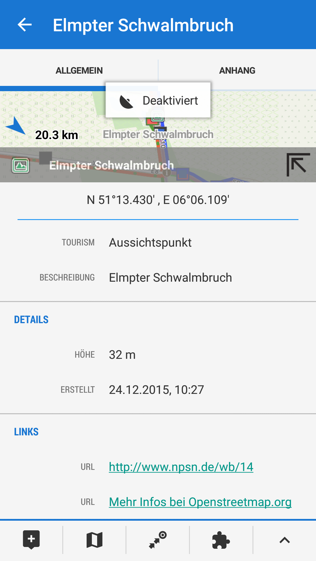
The question was more related to additional information for great POI's. If I check a POI I recognize different URL's (see picture below) and wonder if I can link them back to an URL like www.whentobewhere.com which holds important information about the "when" to be at this place. The Openstreetmap URL seems to be common but what is about the other one found at this place? Why does it show up? 4290f176a0f98e22c85c2caaeceb706b

photo
1

Markus, kannst du (mir) das bitte nochmal auf deutsch formulieren?

photo
1

Martin gerne: ich frage mich woher bei der Option "Interessante Orte" (BETA)" die URL's kommen. Es scheint das per Default hier immer der Link zu Openstreetmap.org eingetragen ist. Aber in obigem Beispiel (das ist aber der einzige POI den ich bisher gefunden habe) gibt es zusätzlich einen Link zu http://www.npsp.de. Wie kommt der Link da rein? auf Openstreetmap habe ich nichts dazu gefunden. Es wäre gut wenn man (wo auch immer) hier Links mit zusätzlichen Informationen ergänzen könnte die dann aus Locus aufgerufen werden. Als Beispiel "Rohrdommelfläche, N 51°19.982' , E 06°14.467'" hier könnten Links zu http://www.whentobewhere.com/travel-listing/rohrdommel-projektgebiet und http://www.bsks.de/ Sinn machen. Evtl. gibt es in Locus aber auch eine andere Möglichkeit solche Links mit aufzunehmen?

photo
2

Markus, u talk about different topic! please STOP it and open a new one.

because

http://docs.locusmap.eu/doku.php?id=manual:user_guide:functions:quick_bookmark

and

http://docs.locusmap.eu/doku.php?id=manual:user_guide:points:locus_maps_pois

are not the same

photo
1

ok understand and sorry to mix this up. Unfortunatelly I was not able to find the first option in the app in the first run. This was due to the fact that the help you referred to show a different icon . This has caused the confusion. Please feel free to delete this post. I'll create a new one.

photo
1

I would appreciate Flickr as a global photo service and I believe there are a lot of Bing maps users. Wheelmap is a free service for the disabled people and as such could be useful too. I'm not much familiarized with the Guidemate service as it offers voice guides that I don't use with quite poor coverage out of Germany.

Replies have been locked on this page!