
Not solved !!!
GPX-Track generated on Locus Pro.
Hello Michal,
I don't use voice-commands. Currently I only use the purple route-line on the screen.
Negative: This purple route-line follows not exactly the gps-Track.
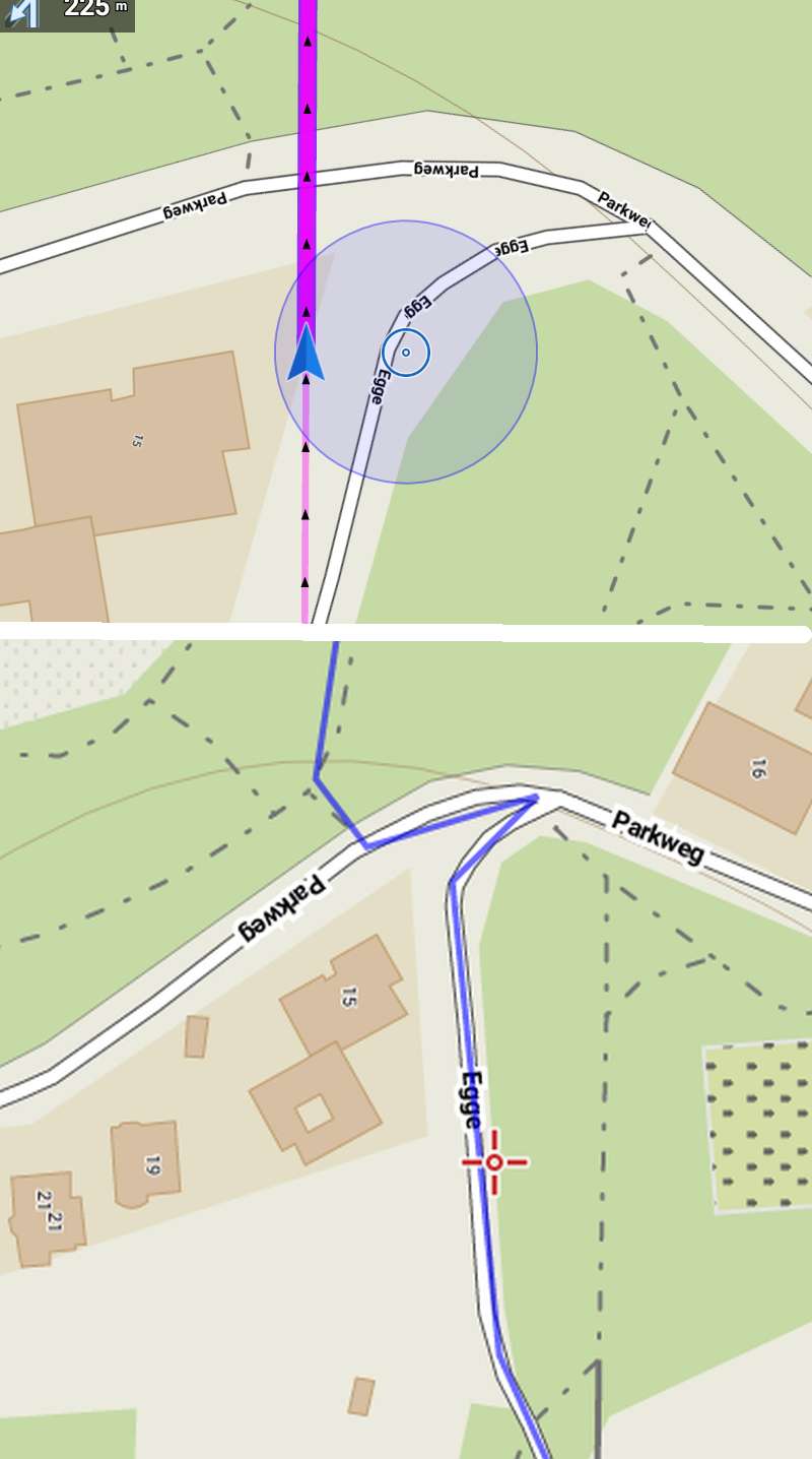
Four new examples.
Best regards
Norbert
 The same problem
What navigation do you use ? Is possible the area was recently modified in OSM and the OSM routing data differ from the OSM data the map is based on ?
Can you provide the location coordinate or the link to it, to reproduce the problem ?
What navigation do you use ? Is possible the area was recently modified in OSM and the OSM routing data differ from the OSM data the map is based on ?
Can you provide the location coordinate or the link to it, to reproduce the problem ?
Hi,
do you have any automatic recalculation ON? If yes then Libor's remark can be true.
Hi,
do you have any automatic recalculation ON? If yes then Libor's remark can be true.
Probably by navigation based on trackshape, no router service involved.
@ Josten What Locus version in use ? In picture: Speed 0.2 kmh.
Navigation by actual Locus Pro 3.25.1 (Speedindication: 18kmh.)
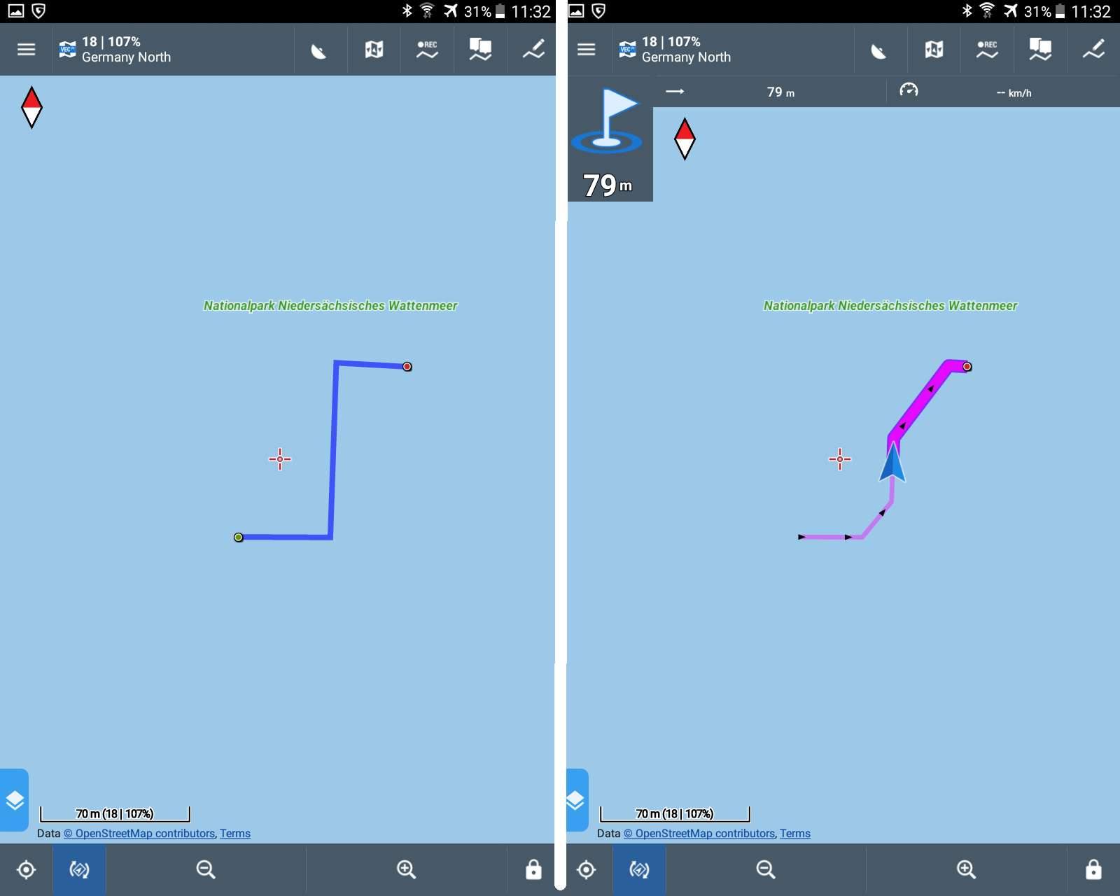
Tested by +/- similar track. A simple short gpx in zip file and see:
3 x tcx course generated by Locus Navigation (Low/Medium/High)
1 x tcx reference generated by JavawaRTWtool (turninstruction trackpoint angle trigger > 50°)
Locus: ->Setting->Navigation->Advanced settings->Number of commands: None,Low,Medium,High.
Josten advise 1 : Or use "None" or use "High" ( A lot of instructions, displays some small trackchange)
@Menion, suggestion: Remove Low/Medium. As by actual development system by router is most important/popular.
Josten advise 2. Use imported gpx as template and by few 'clicks' using routerservice (Brouter or online) generates you a new track with correct and minimal instructions.
Probably by navigation based on trackshape, no router service involved.
@ Josten What Locus version in use ? In picture: Speed 0.2 kmh.
Navigation by actual Locus Pro 3.25.1 (Speedindication: 18kmh.)
Tested by +/- similar track. A simple short gpx in zip file and see:
3 x tcx course generated by Locus Navigation (Low/Medium/High)
1 x tcx reference generated by JavawaRTWtool (turninstruction trackpoint angle trigger > 50°)
Locus: ->Setting->Navigation->Advanced settings->Number of commands: None,Low,Medium,High.
Josten advise 1 : Or use "None" or use "High" ( A lot of instructions, displays some small trackchange)
@Menion, suggestion: Remove Low/Medium. As by actual development system by router is most important/popular.
Josten advise 2. Use imported gpx as template and by few 'clicks' using routerservice (Brouter or online) generates you a new track with correct and minimal instructions.
Hello Michal,
1) I use the navigation in Locus: Tracks > bike > klick on the imported gpx-Track > klick the button navigation at the bottom > than word "Navigation" > than zoom on the current GPS-Point, where I am
2) Same problem with all Tracks. Any location coordinates.
3) recalculation OFF
4) Locus 3.25.5
5) Speed 0.2means: I stopped and made the two hardcopies (png-Files), one with Navigation, one without it (switch it off)
6) Locus: ->Setting->Navigation->Advanced settings-> Strict=OFF, Max=50m, Snap=OFF, Number for voice=Low, Two commands=OFF, End=ON
7) Brouter installed
Best regards Norbert
Does it happen even for GPX tracks generated by BRouter or any other OSM based router ? Or just for track prepared manually or imported from other, non OSM based sources ?
As for the latter the navigation may not follow the track, in contrary to guidance. In such a case, or if not using OSM map, or if OSM map or routing data are old, results may be strange.
Is BRouter also configured to be used in Locus ? What profile ?
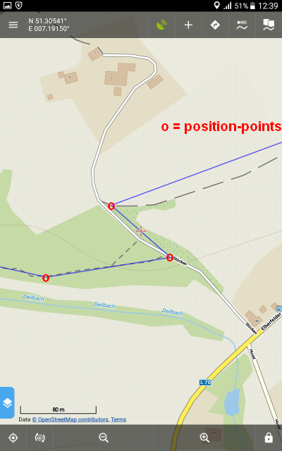
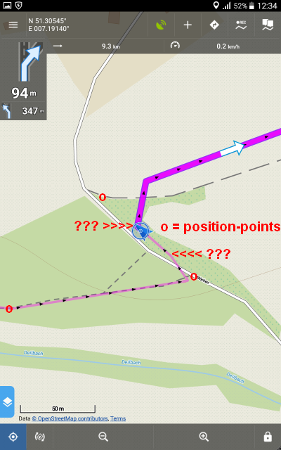
- GPX-Tracks generated on gpsies.com.
- BRouter was already installed. I tested some settings, no change.
- New Screenshots made at home. Location coordinates in water, the north sea.
First screenshot only with blue Line, caused of the imported file "Norbert-test.gpx".
Second, I switch on the "Navigation" in Locus. You see the wide purple line.
But with two additional kink points.
Best regards Norbert
Hi Norbert,
I can't simulate the issue with your test route:
Will you please share the problematic GPSies route here so I can test it? Thanks
Hi Norbert,
I can't simulate the issue with your test route:
Will you please share the problematic GPSies route here so I can test it? Thanks
Good day guys,
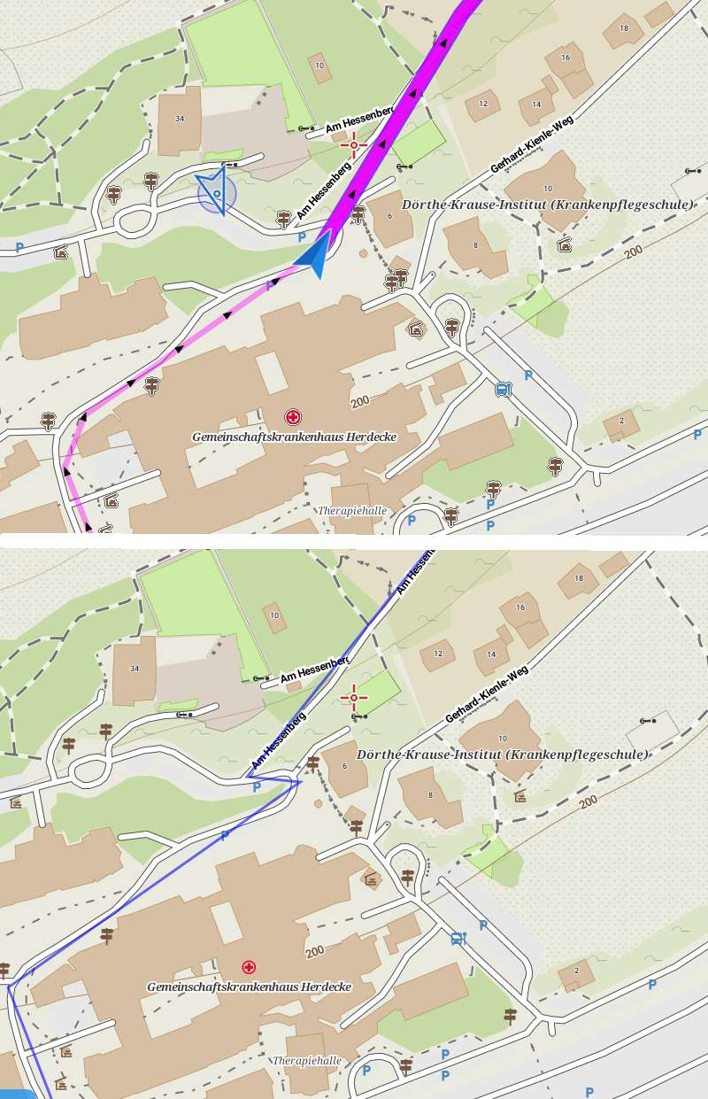
cannot say this is directly an "issue". In case of track with navigation and selected other then "none" in number of navigation commands settings, Locus automatically generated new track with points after exactly same distance and then try to estimate navigation command suitable for certain area.
So simply, in case of selected "small number of commands", Locus Map generate new track based on source track with points exactly 30 metres between. And what you see is the result. What may happen in worst case, is around 15 m error, which I consider as really minor problem. Ok?
Good day guys,
cannot say this is directly an "issue". In case of track with navigation and selected other then "none" in number of navigation commands settings, Locus automatically generated new track with points after exactly same distance and then try to estimate navigation command suitable for certain area.
So simply, in case of selected "small number of commands", Locus Map generate new track based on source track with points exactly 30 metres between. And what you see is the result. What may happen in worst case, is around 15 m error, which I consider as really minor problem. Ok?
No response ... anyway not a big problem in real life I believe. Closed.
No response ... anyway not a big problem in real life I believe. Closed.
Replies have been locked on this page!