
Enable Elevation Profile view when viewing track
Using Locus Map v3.49.0, Android 11.
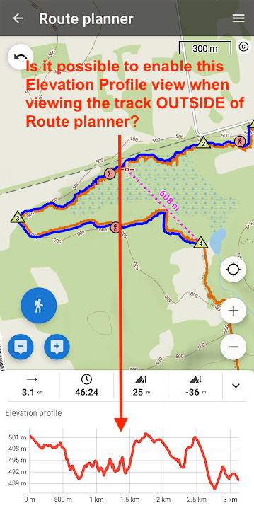
The attached screenshot show the Elevation Profile screen when designing a route. I actually discovered this by an accidentally swipe up.
It would be very convenient to have that same Elevation Profile screen when reviewing a route on the map. By the same swipe up or by hitting a button.
So far I use the "chart" view. The chart view is not good enough because if doesn't show the corresponding route. Yes I also know that it is possible to hit a point on the chart and tap the "see on map" icon to see where the point is on the route. The problem is that this is an irreversible action. Once you are on the map, it is no longer possible to switch back to the chart view. You must start all over again.
I think the best implementation is like in AllTrails where the elevation profile is displayed below the track. Even better, you can scroll (using finger or mouse) horizontally along the the elevation profile and there is a cursor moving on the track to show the corresponding position.
Here is the link to try this interactively: https://www.alltrails.com/explore/trail/canada/ontario/nottawasaga-bluffs-trail?mobileMap=false&ref=sidebar-view-full-map
Would it be OK to add this feature?
Thanks
 I like this idea
I agree. You can quickly compare the elevation profile with the recorded route and for instance find where exactly on your route the biggest grade or incline was and how it decreased along the route. I had this feature on other, previously used apps and have to say I miss it here.
I agree. You can quickly compare the elevation profile with the recorded route and for instance find where exactly on your route the biggest grade or incline was and how it decreased along the route. I had this feature on other, previously used apps and have to say I miss it here.
Replies have been locked on this page!