
This object is in archive!
Chart diagramm: Steepness Profile dont match Height Profile
Closed
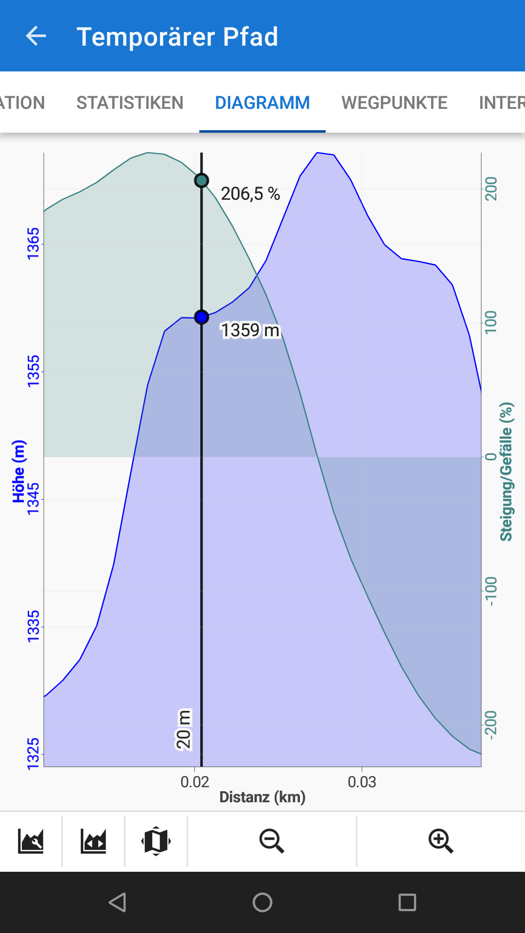
The Steepness Profile do not match to Height Profile. In Flat Regions is still 200% Steepness shown. Steepness Profile seems to be shifted to left. And wrang interpolated.
Its the Profile while Route-Planning. See Attachment.
Files:
Screenshot_2021...
 The same problem
And its not since last changes, Its an "older" problem.
Ok, what i need most is the Height Profile, and This is now Really good.
I would be happy if the steepness profile can get fixed also.
I think it have naybe something to do with filtering some points out of height data
And its not since last changes, Its an "older" problem.
Ok, what i need most is the Height Profile, and This is now Really good.
I would be happy if the steepness profile can get fixed also.
I think it have naybe something to do with filtering some points out of height data
Hi,
could you please provide a graph of a track at least one kilometer long? Thanks.
Hi,
could you please provide a graph of a track at least one kilometer long? Thanks.
Yes sure. Here is the Track. In Flat Regions of height profile, it still shows high steepness. Steepness looks like shifted to the height profile.
Maybe we have to take in account, the Route Interpolation Step, which is used, to also adapt sone parameter of steepness calculation ?
Yes sure. Here is the Track. In Flat Regions of height profile, it still shows high steepness. Steepness looks like shifted to the height profile.
Maybe we have to take in account, the Route Interpolation Step, which is used, to also adapt sone parameter of steepness calculation ?
Here the Track created with manual Route drawing tool.
Here the Track created with manual Route drawing tool.
ahh or... maybe you take in account not just Steepness in Direction of the drawn line ?. but some flat regions are nearby flat in all directions, and still show a Steepness
ahh or... maybe you take in account not just Steepness in Direction of the drawn line ?. but some flat regions are nearby flat in all directions, and still show a Steepness
Hi Markus, but your sample route is not drawn on a flat but across a quarry on a mountain ridge - the elevation differences are changing dramatically on short distances. The graph of elevation and steepness is correct.
Hi Markus, but your sample route is not drawn on a flat but across a quarry on a mountain ridge - the elevation differences are changing dramatically on short distances. The graph of elevation and steepness is correct.
Hello Michal
Also in the Quarry, the "Roads" are nearby flat. And at least on the Roads The Steepness should get also nearby flat. But there the Profile shows still sometimes 200% steepness.
Now i tested again. From a really flat region, one step up. The Profile Line in in fall line. And here you see the Shift.
And i also checked the Roads in the Quarry, are flat in all directions. Yes flat on my used .hgt data in Locus.
Best would be if i give you a link to my detailed data.
Then you can see for yourselfe.
https://drive.google.com/folderview?id=1G8VxspxG7UBbqvTW1xaqPeXoxaqICQc2
If you download:
1. \Data\SRTM\N47E009.hgt
2. \Maps\1_Schummerung_ESG-Rheintal.mbtiles
Then you can check for yourselfe
1st File is Height Data in round about 3m point spacing.
2nd File is raster Hillshade Map in 0,5 m / pixel
.
I use the File "1_Schumnerung_ESG-Rheintal" as overlay to LoMaps. (Overlay multiplicated)
And then sometimes i change the main Map also to the Hillshade Map. (To get a darker hillshade Map because multiplicated to itselfe)
Here some Screenshots of a Profile.And 2 gpx.
Hi Markus,
I discussed the problem with the app author and main developer. He says there is a different filter used for the calculation of steepness than for the elevation chart and when the track is so short, its calculation is delayed. Unification of these two filters would mean a substantial alteration of the system which is not now a priority, regarding other issues. Thanks for understanding.
Replies have been locked on this page!