This object is in archive! 

How to debug WMS loading errors?

Ricardo Rodríguez shared this problem 2 years ago
Closed

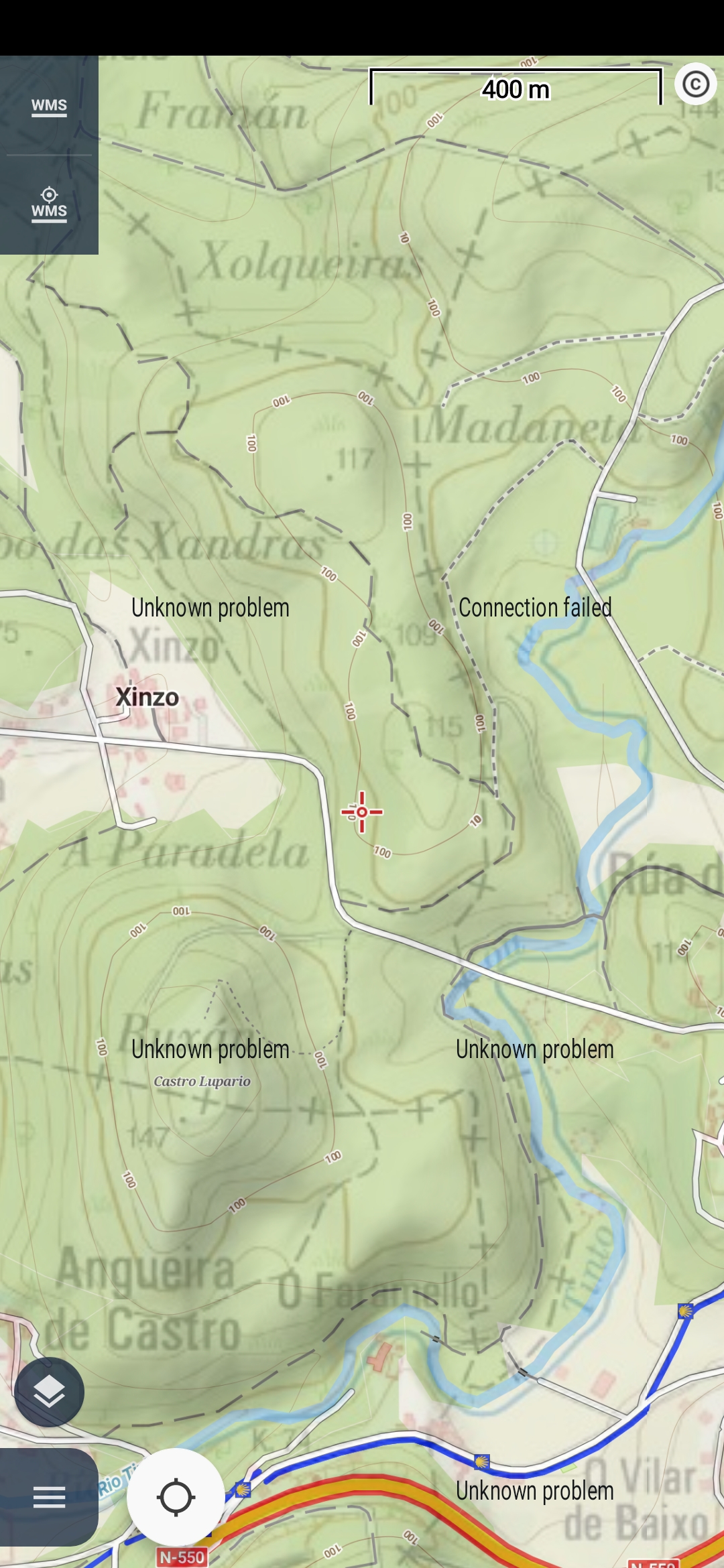
Hi! Since a couple of days ago I'm facing some issue while loading images from a WMS service I've being using without a glitch for at least a couple of years now. The service is up and running as I'm able to read all and any layers by using JOSM. Somehow the issue has some relationship with my Locus Map Android installation.

Please, what tools could I use to generate logs of the process looking for information to describe the problem?

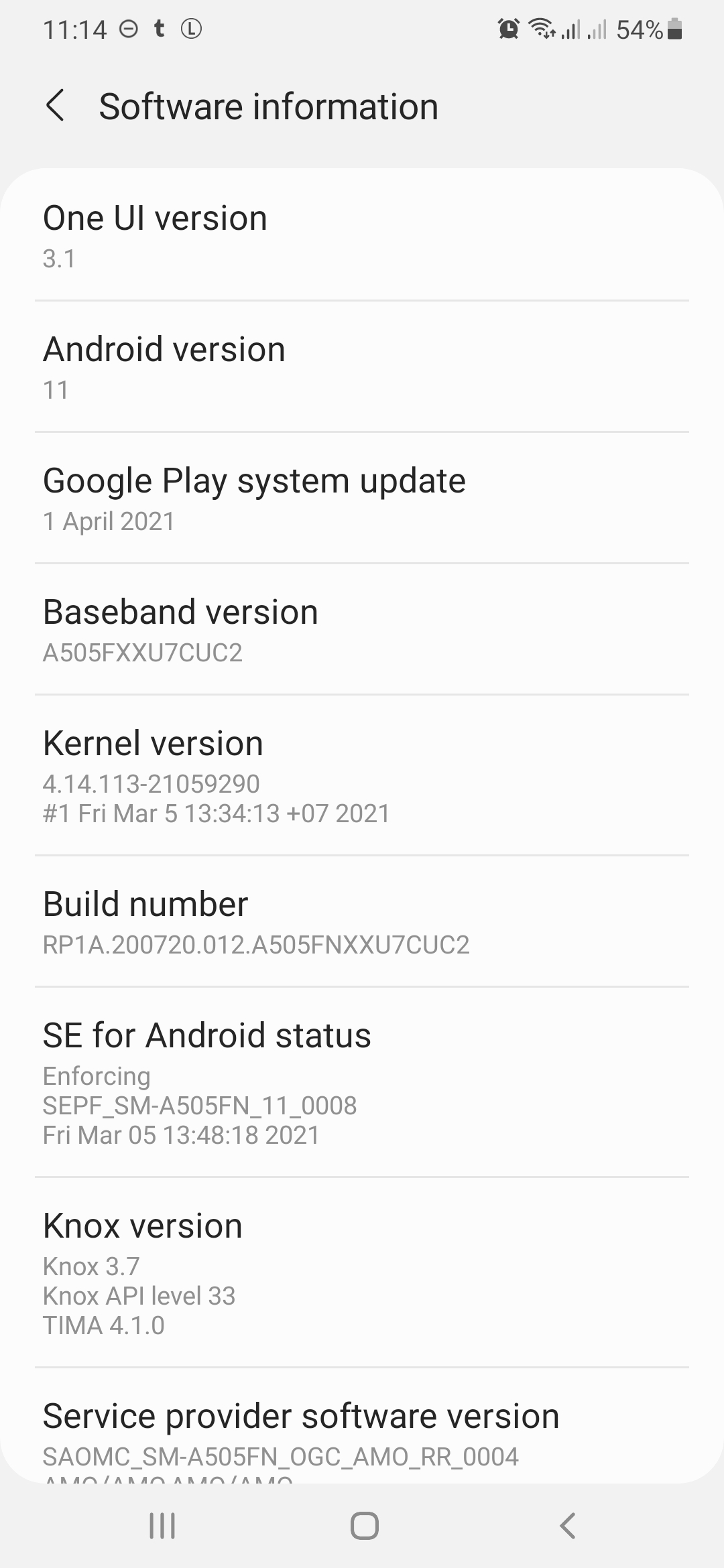
I'm running Android 11 on a Samsung Galaxy A50. Please, see attached images with information about the system and a screenshot with the error message.

Thanks for your help!

Ricardo

Replies (1)

photo
1

Hello Ricardo,

there may be some info in the logs created by the system by this method. It is anyway quite complicated task, mainly to find any info in the generated file. If the WMS map is public, I'll gladly try it and check it if your share a Url to this map with me.


Menion

photo
1

Hi Menion,

Thanks. Yes, it is a public server. It is here: http://mapas.xunta.gal/servizos-wms. It is a service offered by the Galician regional government, Northwest Spain. I was using without a glitch until approximately one week ago these two maps:

Administrative limits of Galicia

http://ideg.xunta.es/servizos/services/Xeoloxia/Litoloxico/MapServer/WMSServer

Lithology of Galicia

http://ideg.xunta.es/servizos/services/Xeoloxia/Litoloxico/MapServer/WMSServer

And still using them with JOSM. Any help will be very welcome! Please, let me if I can do any test to contribute to work out this issue.

Ricardo

photo
1

Still one comment: I see the same behaviour using:

  1. Locus Map 4.1.0 Gold (working directory /sdcard/Locus)
  2. Locus Map Pro 3.52.0 (working directory /sdcard/Locus)
  3. Locus GIS 1.11.0 (working directory /sdcard/locusGIS)

Thanks!

Ricardo

photo
1

Hello Ricardo,

interesting. I do not know what has changed, but seems that the server no longer accepts requests from Locus Map because of how the app format final Url to the map tiles. I've improved it with hope, it won't break compatibility with other wms maps. We will see. Anyway fixed, will work as expected in next Locus Map version.


Menion

photo
1

Thanks! This service has a small but responsive team. I'm sure they will be happy to answer any question at info-iet.cmati@xunta.es.

It is also true that since I started having issues with these two servers, others have also shown weird behaviors at loading tiles time. For instance, this server http://ovc.catastro.meh.es/Cartografia/WMS/ServidorWMS.aspx worked much better in Locus Map and Locus Map Pro before having issues with Lithology and Administrative limits. Also, it works much better in Locus GIS.

Hope this makes some sense for you! I'm keeping enjoying your great job! Thanks!

Ricardo

photo
1

Hi,

thanks for link and extra info. I do not think it is a problem related to particular WMS service. It just > not all work in the app as I expected and as I remembered it worked before :). Anyway new version is just published on the Google Play, so please give it a try and let me know.

photo
1

Hi!

The new release up and running! Now, I'm with 4.1.1 Gold and 3.52.1. All WMS are serving tiles fine, but the two involved in this issue don't offer information for the polygons. Please, see attached screenshot from 4.1.1. Sorry! Please, let me know if I can be of any help!

Thanks for your work!

Ricardo

photo
1

Hello Ricardo,

no need to say sorry!

My quick test:

And result is positive

/384c563b26b2e21e93a116cfa3bf12d9

So I need a steps that should work and doesn't.

Menion

photo
1

Hi! Thanks for the quick test! But this site always worked fine! The sites with problems are in my first reply above. Here they are again for easier access:

Administrative limits of Galicia

http://ideg.xunta.es/servizos/services/Xeoloxia/Litoloxico/MapServer/WMSServer

Lithology of Galicia

http://ideg.xunta.es/servizos/services/Xeoloxia/Litoloxico/MapServer/WMSServer


I've tried again and I keep getting the same message: No available information. I used to get a nice bunch of information a couples of week ago! Please, see attached screenshot. Sorry, I don't remember what release I've installed when I captured this screen. It contents lithological information.


Cheers!

photo
1

Hello,

hmm exactly the same problem as before.

I'm fighting with it the whole evening. And I'm more and more sure, it is a problem on the server.

This is the perfectly valid request

http://ideg.xunta.gal/servizos/services/Xeoloxia/Litoloxico/MapServer/WmsServer?&SERVICE=WMS&VERSION=1.3.0&REQUEST=GetFeatureInfo&CRS=EPSG%3A4326&FORMAT=image%2Fpng&STYLES=&QUERY_LAYERS=0%2C1&LAYERS=0%2C1&INFO_FORMAT=text%2Fhtml&TRANSPARENT=TRUE&BBOX=42.314768%2C-8.873020%2C43.383873%2C-7.414717&WIDTH=512&HEIGHT=512&X=256&Y=256

When send, "%" character is double encoded to

EPSG%3A4326 > EPSG%253A4326

All other services I've tried are able to correctly load similar requests. I've even changed the internal system to a globally used "OkHttp" library and the result is exactly the same.

So suggest contacting the owners of this server with a link to my post here. Hope this helps.

Jiří M. aka Menion

photo
1

Thanks, Jiří.

Please, before contacting them, I would like to understand the issue better. I see that in the GetFeatureInfo URL, we must include the spatial reference system. In this case, EPSG:4326 is correctly encoded in the URL as EPSG%3A4326).

Please, when is it wrongly encoded as EPSG%253A4326?

Cheers,


Ricardo

photo
2

Hello,

in this case, as I understand it, "EPSG:4326" is a text value, not directly content of the URL but just a query value. In this case, it is encoded EPSG%3A4326 and when the final URL is prepared to send, the "%" character is again encoded as "%25".

You may try it when you copy a long URL into the web browser. In the browser URL field, you should see this "double-encoding".

I was also a little bit surprised to see this to be true (I'm not an HTTP expert), but in the end, it makes sense to me. Hope this explanation is clear.

Menion

photo
1

Hi!

I've tried to make my mind about this issue while cycling in the woods yesterday and there is still something I'm not able to understand.

If I post the request you proposed above in a web browser and hit enter, I get a Bad Request response status code:

72626a2a684ee8ab6e409cc35cafe939

If I decode it by using https://meyerweb.com/eric/tools/dencoder/, I get a well-formed response:

84fbd6e93f35b7aef6c3b45ce282dd39I guess the involved ArcGIS server is not accepting encoded URL request from Locus Map as a valid request, but it is accepting decoded URLs without any problem. I see that other WMS servers should be accepting encoded URLs without problem as I can get valid GetFeatureInfo responses from them.

Please, does this make sense to you?

One more question: how could I capture the URL sent to the server when I hit Locus Map WMS GetFeatureInfo button?

Thanks!

Ricardo

photo
1

Hello Ricardo,

yes, I understand it exactly like your wrote > problem on the server with double-encoded values.

And url app send can't be simple seen in common versions. For this, you need a version that print these logs to catlog system and also a tool that is able to display them (Android Studio application for example). Not sure if you want to deal with it ...

Menion

photo
1

Hi Menion,

I'll be happy to try it although I'm afraid I won't be of great help. It is mostly curiosity that drives me. I do like to understand what is going on under the scene. Sometimes this helps others to work out some issues.

Please, how could I get that Locus Map version?

Thanks!

Ricardo

photo
2

Hello Ricardo,

sorry for the delay in my response. I was waiting for a new Beta version. It is ready for the test now: https://forum.locusmap.eu/index.php?topic=7369.msg63856#msg63856 (download link is in my footer).

This version should print links into logcat (or into file if enabled in the expert settings).

Menion

photo
1

Thanks! I'll do my best to help! The issue with the server above seems related to HTTP calls. HTTPS calls work fine:

https://ideg.xunta.gal/servizos/services/Xeoloxia/Litoloxico/MapServer/WmsServer?&SERVICE=WMS&VERSION=1.3.0&REQUEST=GetFeatureInfo&CRS=EPSG:4326&FORMAT=image/png&STYLES=&QUERY_LAYERS=0,1&LAYERS=0,1&INFO_FORMAT=text/html&TRANSPARENT=TRUE&BBOX=42.314768,-8.873020,43.383873,-7.414717&WIDTH=512&HEIGHT=512&X=256&Y=256

The people at IDEG is taking a look at the issue, but it seems related to some change in the security system out of their control.

I'll keep this thread updated! Thanks for your work!

Ricardo

Replies have been locked on this page!