
This object is in archive!
Add wikipedia to the map screen content
Declined
map screen content can show points, lo points , geotagged photos etc
but to show wikipedia article points, you have to search for all wikipedia articles, then look at map
Would a wikipedia item on the map screen content to show all wikipedia points on the screen make sense, it will save serevral clicks and be easier to find.
 I like this idea
I think OSMand does this nicely.
Locus also should support muscle activities - AND brains :-)
I think OSMand does this nicely.
Locus also should support muscle activities - AND brains :-)
PS: the mapping to an offline Wikipedia should be fully offline, too. Currently that little, yet essential step still needs a network connection. Clicking the embedded link in the text offers offline Wikipedia apps like Aard2, so the last step is fine.
PS: the mapping to an offline Wikipedia should be fully offline, too. Currently that little, yet essential step still needs a network connection. Clicking the embedded link in the text offers offline Wikipedia apps like Aard2, so the last step is fine.
Hi guys, you are reacting to recent changes in the online LoPoints system right? It is important to notice that we did not directly add Wikipedia articles with coordinates into online LoPoints. We (Radim) picked useful and important info and images and attached these data to our existing LoPoints database. More articles will be used over time and probably also some unique points based only on Wikipedia data will be created, but important is, that nothing like "Wikipedia points" exists. @Radim Večerek may correct me.
Because we plan to allow also users to add extra content to existing LoPoints, this idea does not make too much sense. More and more points over time will have extra information/images attached, not just from Wikipedia.
Hello Menion, I referred to an old discussion, years ago, about the mechanics of identifying Wikipedia entries with geo tags. Some other guy did provide a database or service back then.
Your point of a general powerful POI framework, with user self service option, is great, as long as it allows offline use as well.
That would require a separate .db file imho, to avoid update disasters ...
TXs and cheers
Michael
PS: such a framework provided, the only thing needed for Wikipedia stubs is someone who filters all Wikipedia items that have geo information (like the other guy from years back did), and then use the self service feature of your POI framework.
Hi, all. A bit of more detailed description of what we have done in this first step: As @Menion said, we only "enhanced" already existing db. We used already existing, human-written links to wiki-world (wikidata, to be exact) present quite often in the OSM dataset. There is no "clever" matching between OSM and Wikipedia so far. This matching, based on categories (articles in wiki, entities in OSM) and location may or may not be another step. Please notice the word matching. If there is an article of interesting category, very likely there already is a POI built from OSM. Then the original POI is responsible for managing "lifecycle" based on real world events.
Example from mountains where I live. A mountain hut burned. The ruin has been removed, there is just some concrete basement. Now OSM dataset has tools to map the hut as "demolished, abandoned, ...more possibilities" or remove it completely. This poor building disappears from POI db next week once the update is done. If we use Wikipedia as equally important source for points creation (and notice again - points management), what now? Someone updates the article as "former mountain hut, now ruin", but the article has right and reason to exist, including pictures e.t.c. This is (primarily) why I reason against the concept of "take everything that has location in wikipedias and display it".
Thank you, Radim, for your explanation.
I agree that geo tag in Wikipedia should not overwhelm the curated POI ecosystem of OSM in general, and Locus POIs in particular.
Whatever you will do with Locus POIs, it will be a constant battle against weird events, combinations, creativity in unregulated OSM etc.
But this is not my real point.
I would like to see offline DBs that simply answer to "show me all Wikipedia entries that relate to the screen I am viewing". It is doable with the mechanics Locus has or will have soon.
And such a clear positioning would take away any complexity for the Locus team. You do not like what you see? Edit Wikipedia, not argue with Locus.
What you may select for your Locus POIs is difficult, in contrast.
Both offerings would use the same Locus features, that is clear.
I see, you mean another, separate, probably optional layer of all wikipedia entries only, not related to existing POIs. Technically, this would be easier than anything else. But there are purists, who want things clean and simple and they need to be persuaded too :-)
I see, you mean another, separate, probably optional layer of all wikipedia entries only, not related to existing POIs. Technically, this would be easier than anything else. But there are purists, who want things clean and simple and they need to be persuaded too :-)
Even a purist should understand that "vanilla Wikipedia" is as pure as a definition can be :-)
And it is not even competing with the curated stuff, where curation adds much value - and work (and pot. trouble ...)
Both offerings are orthogonal to each other, complementing in a way, not mutually harming.
And yes - simple optional switch on/off.
Can someone please explain to me where to find the information from Wikipedia (pictures and descriptions) LoPoints? I click on the most characteristic point of my city Cracow and there is no information at all about Wawel Royal Castle :(
PL
https://pl.wikipedia.org/wiki/Zamek_Królewski_na_Wawelu
ENG
https://en.wikipedia.org/wiki/Wawel_Castle
Do any additional settings need to be made in order to use Wikipedia? Where should I look for this information, where is it displayed?
Hi Endrju. In case of Wawel (and another large castles too), pictures and articles are attached to specific features (the inner king's castle , towers, garden e.t.c.). It's not like everything is encapsulated by the outer wall map feature. A few pictures attached. There is a more generic article about Wawel as a hill attached to the "peak" map feature. I agree, the article about the whole castle you linked should be attached to the "castle" map feature, but it seems it is just not done in the underlying datasets. Anyway this may be solved in the future. So far we only use links that human mappers wrote. Also, it looks like you keep the offline POIs switched on too. Offline POIs do not have any online "extra" data, at least for now.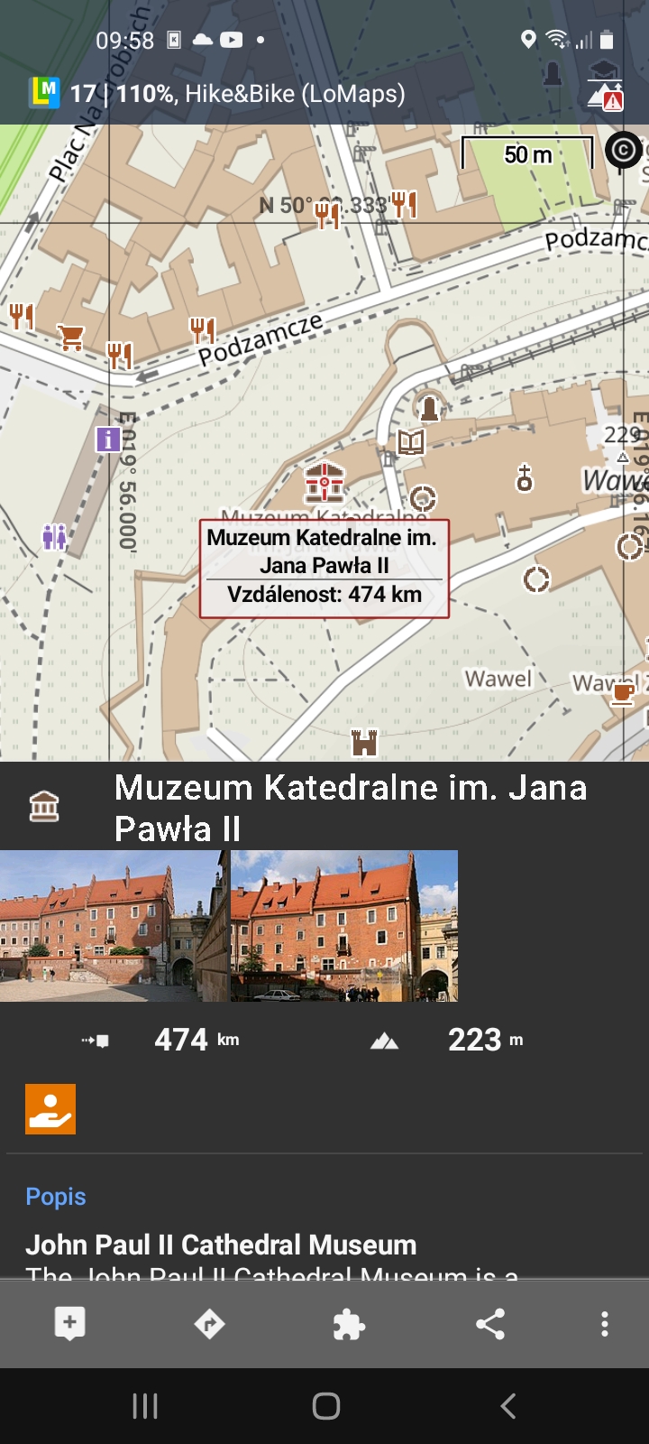
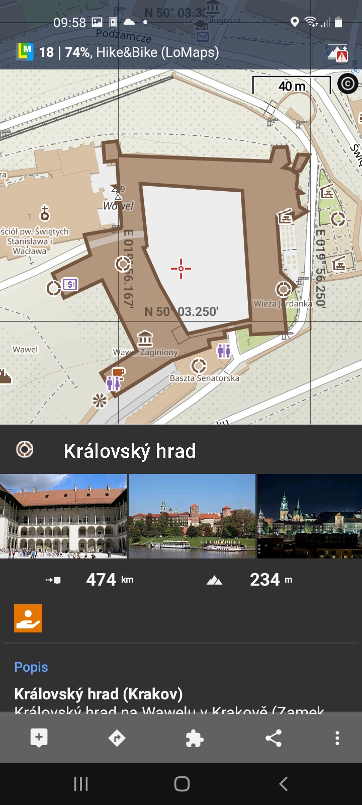
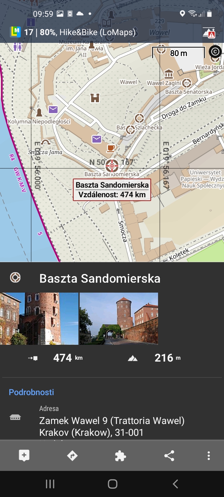
Hi Endrju. In case of Wawel (and another large castles too), pictures and articles are attached to specific features (the inner king's castle , towers, garden e.t.c.). It's not like everything is encapsulated by the outer wall map feature. A few pictures attached. There is a more generic article about Wawel as a hill attached to the "peak" map feature. I agree, the article about the whole castle you linked should be attached to the "castle" map feature, but it seems it is just not done in the underlying datasets. Anyway this may be solved in the future. So far we only use links that human mappers wrote. Also, it looks like you keep the offline POIs switched on too. Offline POIs do not have any online "extra" data, at least for now.


You see - with a full geo Wikipedia data set (easy as you say), such questions would never arise :-)
You see - with a full geo Wikipedia data set (easy as you say), such questions would never arise :-)
PS: and this could be a minimal data set, no extract from Wikipedia needed, if you want. Just the reference, as a local Wikipedia app or a browser (online) would have to serve for the content. That keeps the Wikipedia.dbs (per country/province, per your current partitioning) as small as possible.
PS: and this could be a minimal data set, no extract from Wikipedia needed, if you want. Just the reference, as a local Wikipedia app or a browser (online) would have to serve for the content. That keeps the Wikipedia.dbs (per country/province, per your current partitioning) as small as possible.
Hi guys,
I understand your idea of course. Anyway, with the recent updates in how online LoPoints deal with the Wikipedia, separate "Wikipedia search" in the app makes less and less sense and from my point of view, it is a very hot adept for complete removal. So sorry, the idea declined. There won't be any extra updates in the direct Wikipedia search and it should be really expected that this search will be removed once we will be satisfied with direct Wikipedia integration into LoPoints. Thanks for understanding.
Hello Menion,
from the information so far about the planned integration into LoPoints, Locus Wikipedia information will suck - always, and cause trouble.
An extra DB with Wikipedia geo links (only) for the respective geography gives peace of mind for the Locus team, and full information from Wikipipedia. And responsibility for the entries lies with Wikipedia, not the pour soul doing selection/redaction and curation. I understand that you may WANT to add specific content from Wikipedia to your LoPoints - no worries about that. But you are missing the vast amount of information you are going to ingnore, right?
Just had a look at a set of exported wikipedia extries in to points, and lopoints, in my local villages, there is some crossover where lopoints feature wikipedia entries. but there are a large amount of wikipedia entries that arent in lopoints, it looks to be mostly town/village infomation and statitiscs, ie a wikipedia point for the name of the village, or odd houses.
there is bound to be discrepancies when you venn diagram the overlap of an encyclopedia and a map....
user addable lopoints sounds good..
so im happy with declined status of my idea
if lopoints can georeference online wikipedia by location
can they also access other sources? panaramio? google photos? google earth images?
@Michael Bechtold
right, there will always be some "lost". We will never be able to find a 100% match of all articles to LoPoins. And it is ok. Radim will be working to bring as match correctly merged content as possible. Why waste time on support for any extra database with Wikipedia links? I do not understand. If there is interest, anyone may create such a feature as a separate add-on. Everything needed is already available in the Locus API system.
@Alistair Parsons
I'm not sure if Radim is already read to receive some feedback and tips on missing articles. It is on him. Anyway, I believe there is still a lot of work to do we are aware of.
About additional sources > we do not know any useful for now. Panoramio is dead, Google Photos are limited by price and licence, same with Google Earth. That's why we decided to build our own system.
Regarding the "missing" content: So far we only use human-introduced explicit links pointing osm -> wiki. Doing something more heuristic based (matching based on categories of articles and their location) is certainly possible. This will reduce the "loss". How great this reduction will be is hard to estimate for me, until something is really processed. I am afraid the number of new matches will not be large, if we use some reasonable strategy. (To map e.g. geo-tagged historic events to castles just to increase the amount of data looks just wrong to me). Creating new points in the middle of nowhere, not linked to e.g. existing memorial as say "interesting fact" - questionable too.
One more note: vast majority of points of real interest in hike-bike focused db will never have any link to wikipedia, google, whatever. I mean shelters, mountain huts, sources of water in the landscape, firepits, campsites. Here community based content is the answer imo.
Appreciate the discussion, Menion and Radim.
Yet, can you pls. explain how an addon and/or community based approach would allow an offline answer to the - valid - question:
Show me - OFFLINE - EVERYTHING (item) Wikipedia knows for the visible area of Locus - and provide a link to the real (offline) Wikipedia?
TXs and cheers
Michael
PS: if you provide the procedure/tool (easy as you say), I trust the community (myself included) can provide the processing to build the mapping database (if that is not too big, one for the whole world would make life easier for everybody).
TXs for clarification.
Not easy, got it, but doable.
But why would you kill the existing functionality?? As far as I understand the integration into LoPoints delivers less, yet in a more integrated way.
TXs for clarification.
Not easy, got it, but doable.
But why would you kill the existing functionality?? As far as I understand the integration into LoPoints delivers less, yet in a more integrated way.
Making locus features better is always better than confusing interface with extra features...and maintaining little used features doesnt make sense, but rather than removing, could it be hidden in advanced settings to turn on.off Also if user had the wimipedia offline app installed, could that open the wikipedia articles instead to give offline access?
Making locus features better is always better than confusing interface with extra features...and maintaining little used features doesnt make sense, but rather than removing, could it be hidden in advanced settings to turn on.off Also if user had the wimipedia offline app installed, could that open the wikipedia articles instead to give offline access?
@Alistair: if you have Aard2 installed, Locus can directly open this offline Wikipedia - currently, with the feature still intact.
@Radim: I would indeed be interested in this pipeline for constructing such a db. Thank you
@ Hand & Alistair: interesting websites. Cool - if you are online.
@Alistair: if you have Aard2 installed, Locus can directly open this offline Wikipedia - currently, with the feature still intact.
@Radim: I would indeed be interested in this pipeline for constructing such a db. Thank you
@ Hand & Alistair: interesting websites. Cool - if you are online.
I have Kiwix installed, too.
E Wikipedia: Aard2 - 16 GB, Kiwix 90 GB, because they include images. Even without them, they use 35 GB.
The Kiwix Guru claimed this is because of full text index, but I think this does not work on Android anymore. Biggest issue: he was not supportive catching the message from other apps to open an item. I gave up back then.
Maybe someone else has a good connection to them?
One of the bets bits of viewranger was the publicised routes, wikipedia has a lot of content for publicised places, there must be some way to get info like this and add to locus so people can see easily whats available nearby, adding photos to lopoints is a great start,
One of the bets bits of viewranger was the publicised routes, wikipedia has a lot of content for publicised places, there must be some way to get info like this and add to locus so people can see easily whats available nearby, adding photos to lopoints is a great start,
Replies have been locked on this page!