
This object is in archive!
Incorrect true bearing between my location & target
Not a Problem
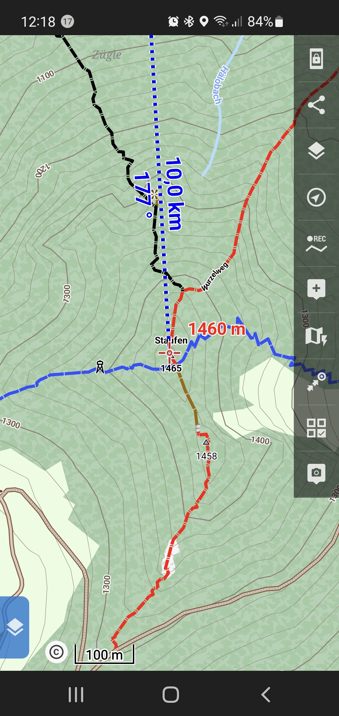
The app does show a wrong azimuth on the map from current gps location to the cursor on the map (line in blue with blue number of azimuth (in the screenshot 177°).
This angle must NOT change, once the setting/sensor "tatsächliche ausrichtung/true bearer" is turned off. It shows the correct azimuth while the setting is ON, but it shows a wrong one, if it is OFF.
BR Martin
 The same problem
Hello Martin,
I'm testing it and all seems to be correct to me.
With the "True bearing" on, the app displays angle aligned with them map, so south/north are exactly 180°/0°. If you turn this settings off, app use angle measured from the north magnetic pole, so angle moved by the current declination value. You may see declination value in the app compass.
Does it make sense to you? Feel free to write to me in case, something is not clear.
Jiří M. aka Menion
Hi
I know about declination and this is the currently shown difference.
But in this case the app's use of it is wrong.
We have 2 points on the map and want to show he angle between them:
This angle is NOT dependent on the declincation. Must NOT be.
When to use the declination in Locus.:
- eg. when showing a line from GPS to North (this function is not realy availabe in the app)
- eg. when showing North on the top of the map. This would mean, the map itself has an angle to the device edge (with value of declination)
- eg. when showing a line from GPS into direction of view. Here the azimuth (angle of this direction to "North") is relevant.
Here it would make sense to show an info next to this line about its angle to "North". which can be either Magnetic or Geographic North, how the user wishes.
Hope, this makes sense to you? Feel free to write back in such case I can explain in more detail.
BR Martin
Hi Martin,
I probably do not understand. You wrote "We have 2 points on the map and want to show the angle between them". I do not know the method of how to display the angle between two points. I always need 3 points. And in our case, the third point is a) true north or b) magnetic north. Which one is used is defined in the settings.
What exactly do you expect? Always display angle from the true bearing? Hmm ...
Hi
I see we have the same principal understanding. Although there is a small relevant piece missing:
If you take 2 points and foreach you take the same North reference (either magentic or geographic), then the difference of those 2 measured angles is the angle we are talking about ;-)
... you see, that angle is independent of the declination (as long as you took the same reference for both points)
So yes, it is what you said "Always display the same angle" ... since for this case it must not be taken into consideration.
BR Martin
to make it more clear:
to make it more clear:
Hi Martin,
I probably still miss something.
If I take the classic old hardware compass and place it on the map, the angle to the point from my current location will be the same as when you "true bearing" in the app turns off! If you enable "true bearing", the angle will be computed from the "geographics north pole". Even my colleagues do not understand what is wrong with this system, sorry.
Menion
Locus can show 2 lines
1) showing the viewing direction (with the help of the compass) ... orange line in the screenshot
2) showing the direction of the gps location to a point on the map (cursor) ... blue line in the screenshot
ad 1) here it would make sense to show also the bearing information somewhere on the screen. Here it makes sense to let the user have the choice if he wants to see the bearing to geographic or magentic north
ad 2) this is "working on a map", this should be independent to the compass and declination of current location. When working on a map, the reference is always geographic north. The shown angle information should be IN-dependent on the sensors settings. It should work the same if the device has a build-in compass or not.
I understand, you see the current behaviour maybe as a feature, but I think this is missleading for the blue line (it would be perfect for the orange one, only).
By the way:
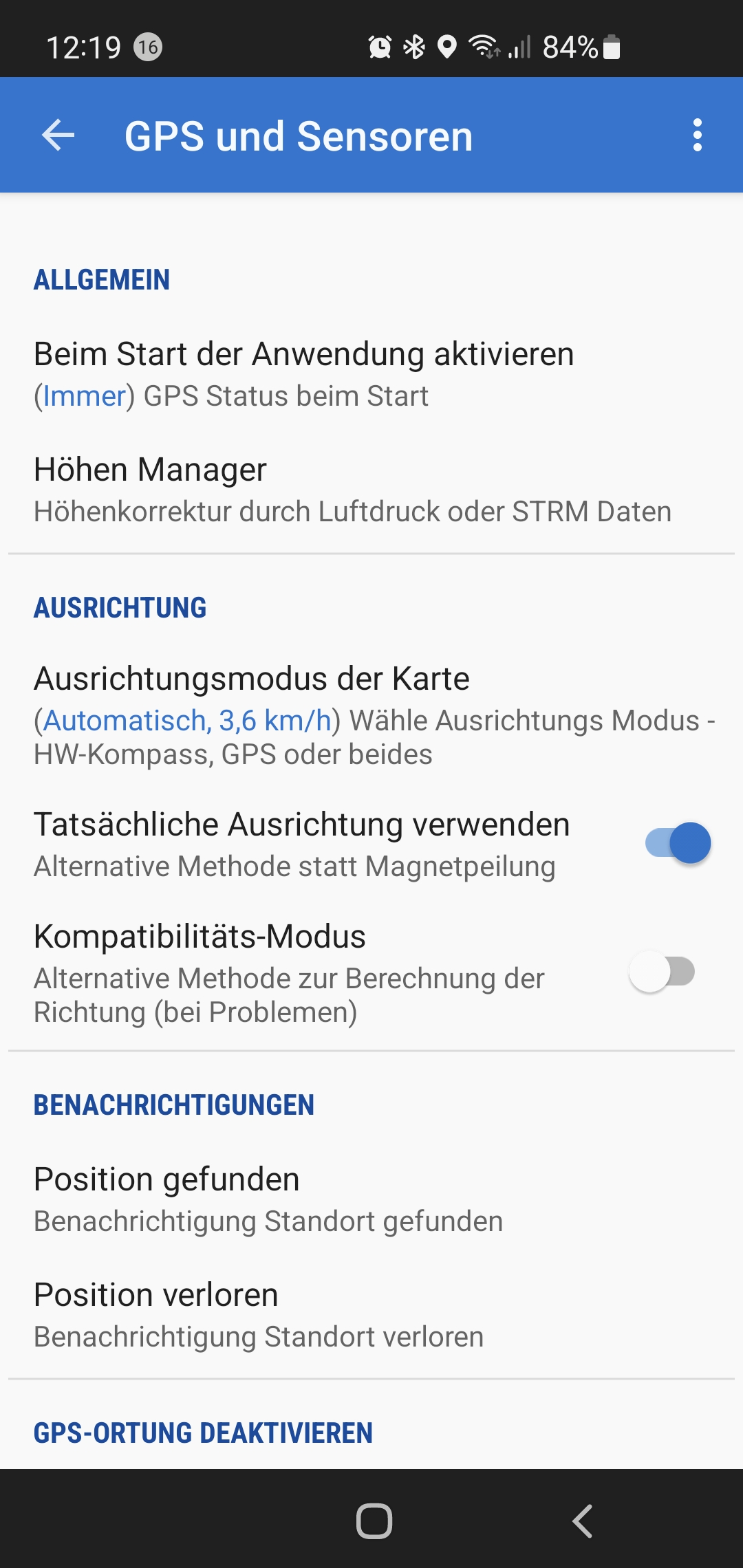
The german translation of this setting is in its subline "Alternative Methode statt Magnetpeilung". In my opinion this is a suboptimal wording. It shoud be "Use Geographic North instead of Magentic for bearer information" ... see screenshot setting.png
And the idea (for the orange line with bearing info). Here the geographic or the magentic angle could be displayed, dependend on the user settings. ... see screenshot orange_option.png
Martin
Locus can show 2 lines
1) showing the viewing direction (with the help of the compass) ... orange line in the screenshot
2) showing the direction of the gps location to a point on the map (cursor) ... blue line in the screenshot
ad 1) here it would make sense to show also the bearing information somewhere on the screen. Here it makes sense to let the user have the choice if he wants to see the bearing to geographic or magentic north
ad 2) this is "working on a map", this should be independent to the compass and declination of current location. When working on a map, the reference is always geographic north. The shown angle information should be IN-dependent on the sensors settings. It should work the same if the device has a build-in compass or not.
I understand, you see the current behaviour maybe as a feature, but I think this is missleading for the blue line (it would be perfect for the orange one, only).
By the way:
The german translation of this setting is in its subline "Alternative Methode statt Magnetpeilung". In my opinion this is a suboptimal wording. It shoud be "Use Geographic North instead of Magentic for bearer information" ... see screenshot setting.png
And the idea (for the orange line with bearing info). Here the geographic or the magentic angle could be displayed, dependend on the user settings. ... see screenshot orange_option.png
Martin
Hello Martin,
thanks for the detailed explanation. I'm really trying to think about it from the user perspective. No matter what is technically correct, one of the biggest problems for me is to have two angles visible on the map screen, where one will be from the "true" and second from the "magnetic" north.
I understand that maps are mostly oriented "true north up", anyway when someone uses magnetic north, I just expect he wants to see all angles oriented regards magnetic north because he does it for any reason.
This feature is in the app for many many years and I never read complaints on the current system. This probably also means, that not many users use this option and keep the default "True north". But also that there is not any serious and confusing problem.
Thanks for the discussion Martin, but I'm still not convinced that current behavior is clearly incorrect or really confusing. Thanks for understanding and your time!
Jiří M. aka Menion
Replies have been locked on this page!