
Can't edit existing track in WebPlanner without triggering recalculate-all #2
please ignore previous topic of same name (or delete) I was making changes, but the editor prevents me from Saving - "No permissions to view this page":
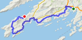
I was trying to edit a 3rd party existing 50km track which was imported into the WebPlanner from a GPX file. It contains approx. 800 valid<trkpt> and valid elevations. There are no Via points. BTW it follows the EuroVelo1 route through southwest Ireland.
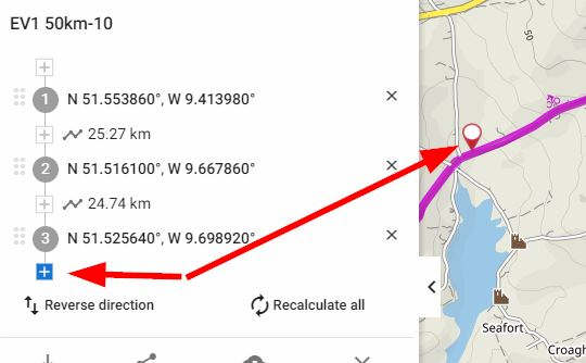
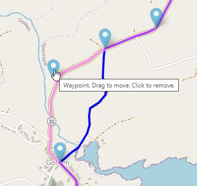
First of all (digression), when the mouse hovers over an existing track segment, the WebPlanner displays the red "pin" icon. Intuitively should a mouse click would then add a Via point into the track segment between any existing points? With the current modal UI model (the key focus is on the + symbol - LHS below), the new point is appended to the track. Confusing? I have to click the + sign between (1) and (2).
But the main problem, as soon as I add that first Via point, the whole track (route) is then lost except of course the start (1), finish (4) and now middle two points (2 & 3) because adding the point triggers recalculate-all. It appears impossible to use the WebPlanner to edit an existing track, so the advantage of big screen WebPlanner+mouse compared to small screen LM app is lost ;-(
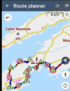
When the same track is displayed in the LM4 app Route Planner, 11 auto Via points and track segment icons are conveniently provided, mostly preventing severe recalculate-all issues, and tapping any track segment icon allows a new Via to be added - context-free:
The editing with BRouter-web (and RideWithGPS-web) are also far more intuitive in this regard. And with the big screen+mouse advantages over the app. BRouter offers to load the GPX as a track (cant edit) or route. In the latter case, like LM4 app Route Planner, auto Via points are conveniently provided which can be dragged (modeless/ context free) or hover over track segment to add another Via point.
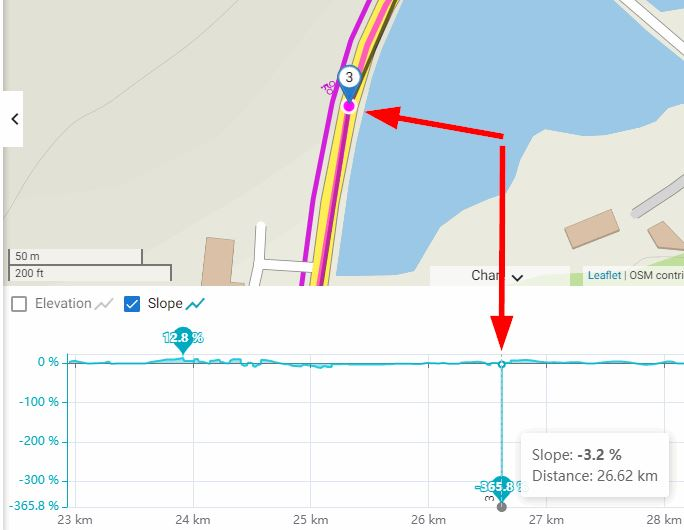
And curiously, the new track also generates a stupid -365% slope along a continuous section of road:
Maybe there are some tips from experts on how to workaround these track editing issues.
It appears my current options are:
- create a new WebPlanner track and "trace" over the existing track, adding Via points to lock the route
- use LM4 app Route Planner, and sacrifice the efficiency of big screen+mouse
- use BRouter-web (preferred)
 The same question
hover > right click on red pin icon - what about 2 more menu items - adding a new point?
hover > right click on red pin icon - what about 2 more menu items - adding a new point?
Hi Andrew,
over the past years, there have been a number of enhancements to our software. One key update includes the ability to automatically generate shaping routes when editing an imported route. Could you please confirm that this enhancement has resolved the issue that was reported in your original query?Looking forward to your feedback.
Kind regards, Ondrej
Ich habe das getestet.
1. Versuch:
GPX importieren, im Planer öffnen. Die Route wird exakt nach Vorlage eingezeichnet. Anschließend exportieren und in der Android App importieren.
Keine Navi-Ansagen vorhanden.
2. Versuch
GPX importieren, im Planer öffnen. Route wird exakt nach Vorlage eingezeichnet. Anschließend neu berechnen.
Navi-Befehle sind nun enthalten.
Aber 70% der Route verläuft nach Neuberechnung nicht mehr auf Vorlage.
Viel zu wenig Shaping-Punkte gesetzt. Das gleiche schlechte Ergebnis steht auch im Planer der Android App.
There should be many, many more shaping points. Every 200 or 500 meters
Too many won't do any harm. Or am I wrong
Übersetzt mit DeepL.com (kostenlose Version)
Hi and thank you for your valuable feedback.
About your first concern, when importing a GPX file, the system initially loads only the track data. To get the navigation instructions, you'll need to perform a "Recalculate All". We understand this may seem a bit unclear, and we're considering how we can improve this. Meanwhile, a good procedure would be saving the imported GPX into "My Library" first.
Regarding your second point on shaping points, we truly appreciate your insight. Our goal is to strike a balance between user-friendly interaction and precision. While fewer points may lead to route inconsistencies, too many can complicate the interface and segment editing aspects. Your feedback is crucial and will be discussed with our team for future enhancements.
Kind regards,
Ondrej
Ok, too many points leads to confusion.
Some ideas. Adjust the number of points according to the length of the track. Long track many points, short track few points.
Another possibility would be to set whether you want a few, many or very many points. Each option is then linked to a track length.
I don't know how it is in the web planner with such settings. But in the app you could put it in the route planner settings.
Translated with DeepL.com (free version)
I love using the Web Planner. However, this issue of forcing a recalculate on an imported .gpx file is really frustrating: It took me down a set of stairs on my bike route, where the .gpx file didn't.
I would greatly appreciate this being fixed. (Or am I doing something wrong?).
Thanks,
Doug
I love using the Web Planner. However, this issue of forcing a recalculate on an imported .gpx file is really frustrating: It took me down a set of stairs on my bike route, where the .gpx file didn't.
I would greatly appreciate this being fixed. (Or am I doing something wrong?).
Thanks,
Doug
Replies have been locked on this page!