This object is in archive!
GPX-line gradient coloring depending on steepness
Completed
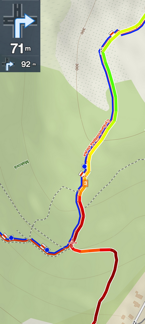
Gpx-line gradient coloring depending on steepness. The steeper the redder.
Use case: to estimate the difficulty of a track (and the amount of time it may take to hike the distance), it would be nice to have a quick glance at the color gradient of the gpx line. A lot of red would indicate that it could be a very intensive track.


 I like this idea
Hello,
coloring is already implemented in Locus.
See the manual: https://docs.locusmap.app/doku.php?id=manual:user_guide:tracks:management#coloring_mode

Or did you mean something different?
Zdenek, Locus team
Hello,
coloring is already implemented in Locus.
See the manual: https://docs.locusmap.app/doku.php?id=manual:user_guide:tracks:management#coloring_mode

Or did you mean something different?
Zdenek, Locus team
Damn! :) How did I miss that!
Thanks for showing me how to enable it! It's awesome!
I'm a very satisfied locusmap user! Thanks for all the great work you all do!
Damn! :) How did I miss that!
Thanks for showing me how to enable it! It's awesome!
I'm a very satisfied locusmap user! Thanks for all the great work you all do!
Missed that too, excellent feature that may be too buried away. Works great on my recorded tracks for some dynamic data types like altitude, slope but how do I get it to show heart rate, for example, I do monitor my heart rate while recording tracks via a Garmin watch linked into locus, there is a setting somewhere that is something like, "save data from all sensors". would this need to be enabled?
Missed that too, excellent feature that may be too buried away. Works great on my recorded tracks for some dynamic data types like altitude, slope but how do I get it to show heart rate, for example, I do monitor my heart rate while recording tracks via a Garmin watch linked into locus, there is a setting somewhere that is something like, "save data from all sensors". would this need to be enabled?
Replies have been locked on this page!