


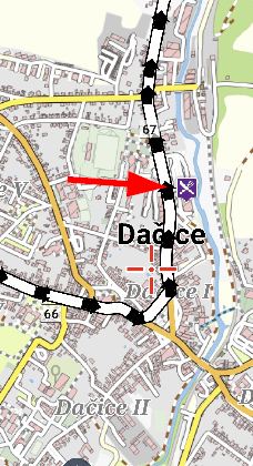
here is a map; note only my point point visible
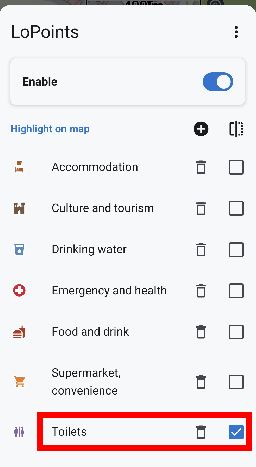
say I only want Toilets LoPoints visible
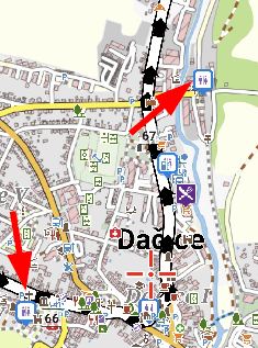
but now every other POI is also displayed making it very difficult to see the Toilet LoPoints; why display these other types when I have not asked?

There are already a lot of POIs and if I have my way there could be even more. More categories are conceivable.
But the overview on the map is already no longer good. When I'm cycling, I only need certain POIs. Or if I'm hiking, I need other POIs. Some POIs I don't need at all. That's why it would be good if I could choose which POIs I want to see. Selection of whole category but also under category, as o POI type.
The whole thing for online POI and offline.
and if I can now attach the whole thing to a preset, that would be brilliant. So I can choose different ones for hiking as for cycling or geocaching.
 I like this idea

Garmin Basecamp has a similar unified system. LM has more confusing POI control - some selected from the map theme, others selected by POI search. This can result in POI duplicates - same POI displayed twice on the map.
Garmin Basecamp has a similar unified system. LM has more confusing POI control - some selected from the map theme, others selected by POI search. This can result in POI duplicates - same POI displayed twice on the map.
Yes, especially for online/offline lopoi it's crucial that we have control over displayed categories.
Yes, especially for online/offline lopoi it's crucial that we have control over displayed categories.
Yes, a control of which POIs are visible has been missing for a long time. As far as I have read, Menion wants to change the offline POIs to match the online ones. Perhaps this task can be carried out at the same time.
Somewhere there was also the idea to show the offline POIs only when there is no internet connection. Then we wouldn't have the problem with the duplicates.
Yes, a control of which POIs are visible has been missing for a long time. As far as I have read, Menion wants to change the offline POIs to match the online ones. Perhaps this task can be carried out at the same time.
Somewhere there was also the idea to show the offline POIs only when there is no internet connection. Then we wouldn't have the problem with the duplicates.
@Tobse - "Then we wouldn't have the problem with the duplicates." - but each theme has independent control over which POI (from .svg file) it wants to display, for example, some XML
so not sure how this would be "overridden" by Locus to avoid potential duplicates?@Tobse - "Then we wouldn't have the problem with the duplicates." - but each theme has independent control over which POI (from .svg file) it wants to display, for example, some XML
so not sure how this would be "overridden" by Locus to avoid potential duplicates?@Tobse: I think you mean this idea with the internet connection. https://forum.locusmap.eu/index.php?topic=8436.msg74458#msg74458
This could also be implemented here but only for LoPOI. Not for OAM POI. Otherwise you can no longer display the OAM POI with an online connection.
Example:
I am online
Online LoPOI activated.
Offline LoPOI deactivated (because of the duplicate)
Now the online connection is interrupted. Locus would automatically switch to the offline LoPOI. As soon as I have an online connection again, Offline LoPOI is deactivated again.
So I have ensured that the LoPOI is always displayed.
@Tobse: I think you mean this idea with the internet connection. https://forum.locusmap.eu/index.php?topic=8436.msg74458#msg74458
This could also be implemented here but only for LoPOI. Not for OAM POI. Otherwise you can no longer display the OAM POI with an online connection.
Example:
I am online
Online LoPOI activated.
Offline LoPOI deactivated (because of the duplicate)
Now the online connection is interrupted. Locus would automatically switch to the offline LoPOI. As soon as I have an online connection again, Offline LoPOI is deactivated again.
So I have ensured that the LoPOI is always displayed.
@freischneider: yes, that's exactly what I meant. Thank you
Your objection makes sense. That's exactly how it could be implemented.
@freischneider: yes, that's exactly what I meant. Thank you
Your objection makes sense. That's exactly how it could be implemented.
Migrating from LocusMap Classic, I'm really missing that feature. Previously I could add 100 points of any category around my current position which was very helpful. In LocusMap 4 only all or no LoPoints can be displayed (there's no filtering/selection possible) - this makes the LoPoints feature absolutely unusable for me now since there are just too many and completely irrelevant icons :-(
It would be a great start to have the 'highlighted lopoints' separate from the 'all lopoints' feature. That way I could easily just display the lopoints I'm interested in and in rare occations enable all points. This would already cover 95% of my usecases.
Migrating from LocusMap Classic, I'm really missing that feature. Previously I could add 100 points of any category around my current position which was very helpful. In LocusMap 4 only all or no LoPoints can be displayed (there's no filtering/selection possible) - this makes the LoPoints feature absolutely unusable for me now since there are just too many and completely irrelevant icons :-(
It would be a great start to have the 'highlighted lopoints' separate from the 'all lopoints' feature. That way I could easily just display the lopoints I'm interested in and in rare occations enable all points. This would already cover 95% of my usecases.
There are now two further ideas on this topic.
https://help.locusmap.eu/topic/38378-show-only-highlighted-lopoints-on-map
https://help.locusmap.eu/topic/39053-lopoints-filtern
The best solution would be to introduce a filter option for normal LoPoi. This would allow me to select what is displayed. Locus should remember this filter. When I turn LoPoi off and on again, the filter should be active again.
The highlighted LoPoi should also work with LoPoi (normal) turned off. This would allow me to display highlighted LoPoi independently of LoPoi, with and without filters.
Another advantage would be if I could save the filter from normal LoPoi in presets.
Translated with DeepL.com (free version)
There are now two further ideas on this topic.
https://help.locusmap.eu/topic/38378-show-only-highlighted-lopoints-on-map
https://help.locusmap.eu/topic/39053-lopoints-filtern
The best solution would be to introduce a filter option for normal LoPoi. This would allow me to select what is displayed. Locus should remember this filter. When I turn LoPoi off and on again, the filter should be active again.
The highlighted LoPoi should also work with LoPoi (normal) turned off. This would allow me to display highlighted LoPoi independently of LoPoi, with and without filters.
Another advantage would be if I could save the filter from normal LoPoi in presets.
Translated with DeepL.com (free version)
This setting is only for highlighting.
To display them, you'd have to create a new setting. I'd like that too. Because there are LoPoi I never want to see.
But There are LoPoi that I would like to display but not highlight.
This setting is only for highlighting.
To display them, you'd have to create a new setting. I'd like that too. Because there are LoPoi I never want to see.
But There are LoPoi that I would like to display but not highlight.
I'm confused - compare my enabled/ disabled maps - the POI are not displayed when Toilets are off. It's not just highlighting, its making all available POI visible. Am I missing your point?
I'm confused - compare my enabled/ disabled maps - the POI are not displayed when Toilets are off. It's not just highlighting, its making all available POI visible. Am I missing your point?
Hi Andrew,
At the moment, there is no option to display only the selected LoPoints category. You can only highlight it and all other LoPoints stay on the map. Or you can hide all LoPoints. The request to add filtering of LoPoints on the map is here: https://help.locusmap.eu/topic/33933-show-only-selected-poi or here: https://help.locusmap.eu/topic/38378-show-only-highlighted-lopoints-on-map. You can vote for them.
Hi Andrew,
At the moment, there is no option to display only the selected LoPoints category. You can only highlight it and all other LoPoints stay on the map. Or you can hide all LoPoints. The request to add filtering of LoPoints on the map is here: https://help.locusmap.eu/topic/33933-show-only-selected-poi or here: https://help.locusmap.eu/topic/38378-show-only-highlighted-lopoints-on-map. You can vote for them.
Hi,
option to display only the highlighted LoPoints will be added in the next app (Beta) version.
Hi,
option to display only the highlighted LoPoints will be added in the next app (Beta) version.
Replies have been locked on this page!