
This object is in archive!
Editing in the web planner
Not a Problem
Hello,
Gentlemen, do something with this edition in the web planner. What you propose is not acceptable, here is an example (a fragment of my route in the Locus-web planner):
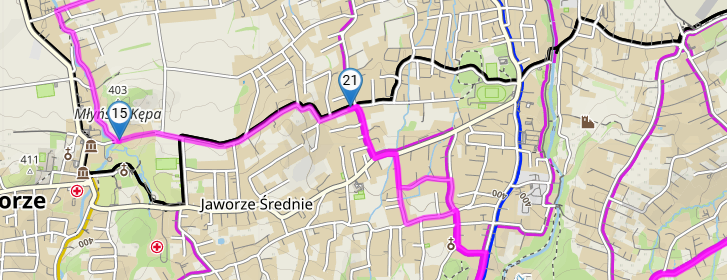
screenshot 01 - shows a section of the route, I plan to change its course from point 15 - along the black trail.
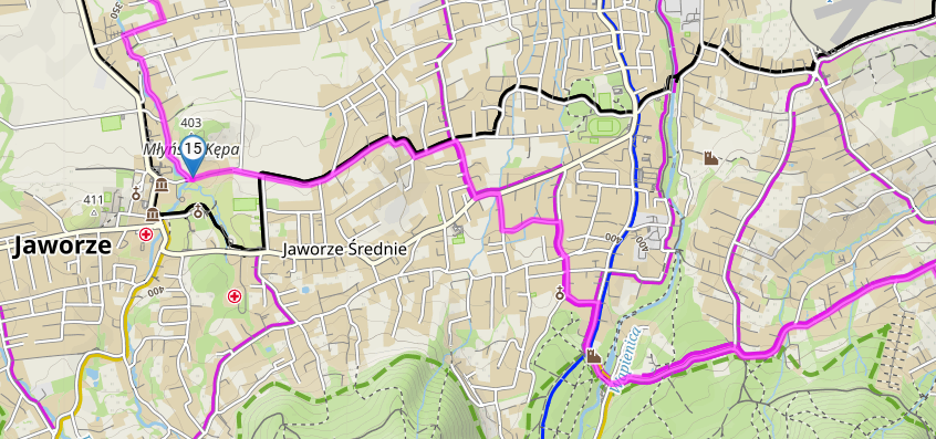
screenshot 02 - I am entering a new point, it should be 16, and the planner has inserted point 21 (the last one). The program should insert point 16 and renumber the points. Point 21 prevents editing at this point because it connects to the final point (50 km away).
I'm really trying to use the Locus-web planner, but it's impossible to work like that.
waldek
 The same problem
it seems like lack of experience - to insert a point either drag the route to the desired location, or notice the + icon in between each exiting point in the panel on the left side - click+ then the next point will be inserted into that sequence instead of being appended to the end of the route. I hope that helps. I find the basic operation very intuitive once learnt.
it seems like lack of experience - to insert a point either drag the route to the desired location, or notice the + icon in between each exiting point in the panel on the left side - click+ then the next point will be inserted into that sequence instead of being appended to the end of the route. I hope that helps. I find the basic operation very intuitive once learnt.
Hi Waldek,
it is as Andrew has written - tap "+" in the route itinerary on the place where you want to insert a route point. Then place the point on the map and it'll be inserted on the selected position. Or, drag and drop the route to where you want it to go.
Hi Waldek,
it is as Andrew has written - tap "+" in the route itinerary on the place where you want to insert a route point. Then place the point on the map and it'll be inserted on the selected position. Or, drag and drop the route to where you want it to go.
Hi,
ok, dragging the route and completing the point.
but clicking on the route inserts the last point +1
and connects him with it.
It is not OK. See pict 01 and 02 - clicking here inserted point 24 (i.e. 23 +1)
Please see how beautifully it works in BRouter!
waldek
Hi,
ok, dragging the route and completing the point.
but clicking on the route inserts the last point +1
and connects him with it.
It is not OK. See pict 01 and 02 - clicking here inserted point 24 (i.e. 23 +1)
Please see how beautifully it works in BRouter!
waldek
observe where the textbox in the left hand panel is when you 'insert point N+1' - you are appending to the route. it just takes a little time to learn, rather than discounting the whole system. just different to BRouter; maybe a little more flexibility.
observe where the textbox in the left hand panel is when you 'insert point N+1' - you are appending to the route. it just takes a little time to learn, rather than discounting the whole system. just different to BRouter; maybe a little more flexibility.
I don't deny the planner, but it is not intuitive.
well, next questions:
A) pict dump 1 - Locus planner
B) pict dump 2 - BR
Interestingly, the map magnification is the same, but the view range is different.
Cycle routes have clear descriptions in BR. They can be turned off.
In Locus planner, bicycle routes are indistinguishable from pedestrian routes. The magnification must be much higher to see the bicycle icon (and this is not always the case).
It would be useful to enable/disable bicycle and pedestrian routes (separate options). Sometimes the display of routes "pollutes" the map too much.
waldek
Replies have been locked on this page!