
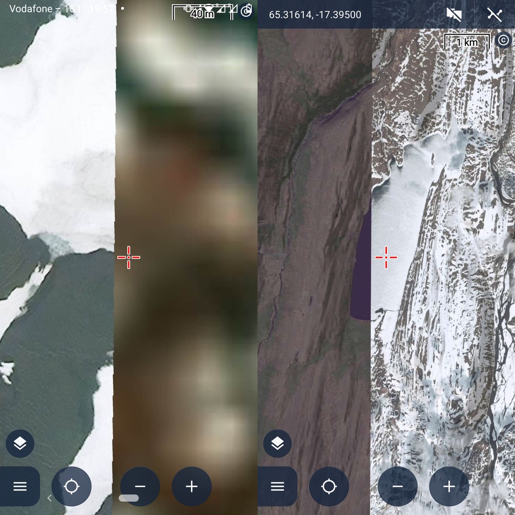
Satellite base map (GOLD): Bad quality in Iceland
In Progress
When I tried Locus' base map "Satellite" (GOLD feature) in Iceland, I repeatedly perceived the imagery is not useful:
- Parts have been shot during cold weather, so ground features are hidden below snow, lakes are frozen thus also snow covered and as white as the surrounding land mass – so lake borders can't be perceived
- Often, clouds hide the ground features
- Partly, resolution is way too low to recognize ground structures that could be obstacles during hikes
Attached some examples.
Could you please check with Sat provider whether he also has a cloudless image set for Iceland?
Is there a way to toggle between different shots? Especially with and without snow.
 The same problem
Thank you for the topic and you're right it's not ideal. We buy data from here.com and I'm not sure if we can get better data from them. Their official website
https://maps.here.com/?map=65.30277,-14.45256,6.66 shows the same data...
Anyway, I contacted the National Land Survey of Iceland to see if there is any WMS or WMTS service with satellite/orthophoto maps that we could use in Locus Map
I'd like to confirm contacting / changing the sat imagery provider is a good idea. To those interested in details: After being outdoors in Iceland for 3 weeks, I can tell that I tried to use Locus' Satellit map around every second day because OSM mapping is not that accurate in Iceland – probably because very few people in a big country where the reality on ground changes extremely quickly, e.g. the volcanic eruption of this weekend covers many km² of existing paths and tracks with lava, while new paths and tracks are created to monitor and view the lava flows. Locus' Satellit map was nearly never usable due to low image quality and because it's rather outdated (the information plates at 64.12549, -19.72500 speak of year 2013 in future tense and are mapped in OSM since 2020 but are not visible in sat images as of 8/2024), while Vespucci's layers mapbox and esri were often usable from quality & updateness, and Bing as well as Google Maps were slightly superior.
Could you please answer whether a possibility to change between different image shots exists? I used this feature a lot e.g. in Google Earth or geoportal.freiburg.de to get more details during tour planning, e.g. different shadow directions making different aspects visible, snow or not, trees having leafs or not,...
Hi,
thank you for the explanation and reminder
There is a reply from LMI (Landmælingar Íslands - a national geo service)
> Unfortunately, we can not licence to you the background satellite image nor the aerial photo image.
> We have tendered out a new coverage that will be openly available but it will first be ready in three years.
There is a WMS service with historical aerialphotos from 1970 - 2000. You can try it via Menu > Maps > WMS /WMTS > plus > Add from library > search for "LMI" and select Aerial Photography Gallery service
>Is there a way to toggle between different shots? Especially with and without snow.
Sorry, but this is not possible with the default online satellite map. There is only one dataset and it is not possible to change it.
Anyway there is maybe a possibility to use the Copernicus/Sentinel program to view custom satellite images from this program- check out the website https://dataspace.copernicus.eu/
- you should be able to select the layers you are interested in, generate your access data and then enter them in Locus (I admit I haven't tried it)
- or webinar https://www.youtube.com/watch?v=dits4g2kVQc
- but the resolution of Copernicus images will not be super detailed
Regards
Petr
For around 2 weeks, I tested v4.30 and hence was able to use sat again. Feedback: I observed that in regions with steeper vertical drop-offs like the Alps, sat is often not usable due to the shadow. Here an example the north face of Eiger and neighbouring mountains:
One solution would be that users can choose from different shots which adds further advantages (snow or no snow? leafs on trees or no leafs?...). So similar to Google Earth, Vespucci, JOSM etc. and many municipal geo information systems.
Another solution would be that the sat image provider (i.e. HERE) does not simply provide one single shot, but does the service to combine different shots to an sat image that is clearly recognizable everywhere (i.e. no hard shadows and no clouds as in Iceland). For north face sides, the provider would need to combine one mid-day shot (all mountain sides except north) and a shot very early in the morning / very late in the evening (north face).
I'm sorry, but we’re unable to offer such a service directly. In most cases, data providers maintain a single global dataset with detailed coverage. I’d recommend checking local WMS services for your area. Specifically, for this region, you can also use the satellite map from Swisstopo, available in the Online Maps section.
However, Please check the article https://www.locusmap.app/how-to-load-free-satellite-imagery-in-locus-map/ It explains how to configure a Sentinel service, including how to define a custom time range for the imagery you're interested in
Replies have been locked on this page!