
This object is in archive!
Total height increase 2-3 times to high
Solved
If you Do bycicle tours the amount of total height increase is interessting.
Since I Use am Google Pixel 7 pro, with its very good GNSS capabilities I get amouts, that are much to high. About 2...3 Times more , than realistic. Even if i correct the hight after the Tour with Locus special function it stays quite abmormal high. For instance a Tour of about 970hm Locus records as 2500hm afterwards corrected it becomes 1700hm.
What could I Do to avoid those failures?
Locus 3.70.11 in Android 14 on Google pixel 7 pro
 The same problem
Hello germangeo,
could you please share your track recording, so I may verify and check expected values? Thanks.
Anyway, you have simply two options
Hope this helps. We have also some more info about it in our Locus Map 4 manual, but the option to specify a custom threshold is not available in the Classic version.
Hi Menion, thank you 4 your reply! I send you one of my gpx files, where Locus said about 2500hm,after correction 1534hm, Strava said 989hm and komoot 920hm.
I think the truth lies AT about 970hm.
Hi Menion, thank you 4 your reply! I send you one of my gpx files, where Locus said about 2500hm,after correction 1534hm, Strava said 989hm and komoot 920hm.
I think the truth lies AT about 970hm.
These are my settings
These are my settings
do you have the altitude data from Sonny ? 1” Lidar
and you should adjust your settings. https://docs.locusmap.app/de/doku.php?id=manual:faq:wrong_gps_data
do you have the altitude data from Sonny ? 1” Lidar
and you should adjust your settings. https://docs.locusmap.app/de/doku.php?id=manual:faq:wrong_gps_data
Thanks for the shared track. I'm testing it by importing into Locus Map 4. Result is 1326m (you may easily test it also on the web https://web.locusmap.app/en/# ). After correction by "Update elevation" with offline elevation files downloaded directly over the app, I get 1166m. With 1'' data from Sonny (as mentioned by me and freischneider), you will probably get a little less, so closer to what you expect.
Anyway to be correct, I'm testing import also into Locus Classic and here I get identical 1327m uphill elevation and 1534m after correction, so here it is same as you. It has been more than 3 years since Locus Classic is only in the maintanance mode and difference between apps is bigger and bigger. Problem here is that Locus Classic does not use mentioned "Threshold" parametr and with less precise offline elevation files, you see that it makes quite a difference.
So sorry, hard to help here. I may really suggest downloading 1'' data from Sonny and using them, this may help a lot in this case I believe. Thanks for understanding.
Hi germangeo,
First of all: I think this is a very scenic bike-tour around the reservoir-lake and its huge dam :-)
Second: Because of its the route's characteristics (very hilly, slopy terrain around most of the track, the track also crosses a dam with a huge elevation difference of its adjacent water levels...) it's quite difficult for devices and software to calculate the "correct" elevation sum of the track. On the other hand a good example to test quality and features of them.
What is relevant here:
1) horizontal accuracy of the track, beacause horizontal deviations due to bad GPS-reception would result in relevant vertical elevation deviations due to the slopy terrain. But what I saw, your track's horizontal quality is quite good for a GPS-created track - hardly any zig-zag's or greater differences to the OSM-pathes there.
2) vertical accuracy of the track: I'm not quite sure since I think you used a mixture of device elevation and correction by locus' elevation files, what is probably not ideal in your case. Since you're using a barometric device, which is ideal: Just use elevation created by the barometric sensor of your phone. Or second solution: Download Sonny 1" elevation files and completely replace your elevation values using them afterwards by "More > Update elevation"
3) Altitude threshold (TH): Because 1) and 2) are quite in good in your case but there are still some deviations cause of the slopy terrain, I'd recommend a TH of 5 m (LM3 uses an unchangeable TH of about 3 m which will lead to slighly too high sums in this terrain surroundings)
Finally the elevation sums in detail:
a) Original values: 1531 m (TH 3m), 1330 m (TH 5m)
b) Updated with Sonny 1" in Locus Classic: 1168 m (TH 3m), (TH 5m: 1040 m) (interestingly my values are very different to Menions' who used Locus classic: Maybe Menion used the same altitude source as you used in your original track, probably SRTM 3" ? )
There are still some slight uncertainties in the track with updated Sonny-data (e.g. crossing of dam is not 0m, some points where you drove close to a slope and returned afterwards...). So I think all in all the "real" sum should be close to 1000 m.
I'm not sure what elevation models and TH Strava and Komoot are using, but I think it's a bit of coincidence that there sums are quite ok here. I'm sure there are other type of routes, e.g. hiking routes in the mountains where they are more off than Locus.
@Menion: I know, you are just offering critical bugfixes to LM3 anymore ;-)
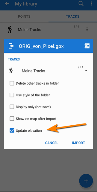
But maybe this is a "critical" one for many users: The "Update elevation" feature within a tracks' import dialog isn't working, it isnt't changing elevation values. As you know, many of Locus' users rely on useful elevation values and -sums. This is not the case if elevations aren't updated - although they think they did - cause they activated the follwing checkbox. In the track dicussed here there's a difference of 1531m => 1168m
@Menion: I know, you are just offering critical bugfixes to LM3 anymore ;-)
But maybe this is a "critical" one for many users: The "Update elevation" feature within a tracks' import dialog isn't working, it isnt't changing elevation values. As you know, many of Locus' users rely on useful elevation values and -sums. This is not the case if elevations aren't updated - although they think they did - cause they activated the follwing checkbox. In the track dicussed here there's a difference of 1531m => 1168m

Thanx 2 Sonny. In will Check that out later. If you like, I attach 2 more very scenic gpx files which may be hight increase relevant too.
Thanx 2 Sonny. In will Check that out later. If you like, I attach 2 more very scenic gpx files which may be hight increase relevant too.
@Sonny, thanks for detailed description. I appology, I was little lazy to describe all in such details, so thanks.
Yes, I use only 3'' in the support (and also in the field), so I use what most of users use.
Problem with "Update elevation" > ah, older problem already solved in Locus Map 4 and not in Classic. Thanks, fixed (next version).
Very cool, thanks a lot for the hotfix even in Locus classic Menion! :-)
Very cool, thanks a lot for the hotfix even in Locus classic Menion! :-)
What does the Threshold particularily do?
What does the Threshold particularily do?
Replies have been locked on this page!