
This object is in archive!
Point instead of recording cursor ?!
Not a Problem
Hi,
I've already reported the problem, but nothing happened. What's going on?
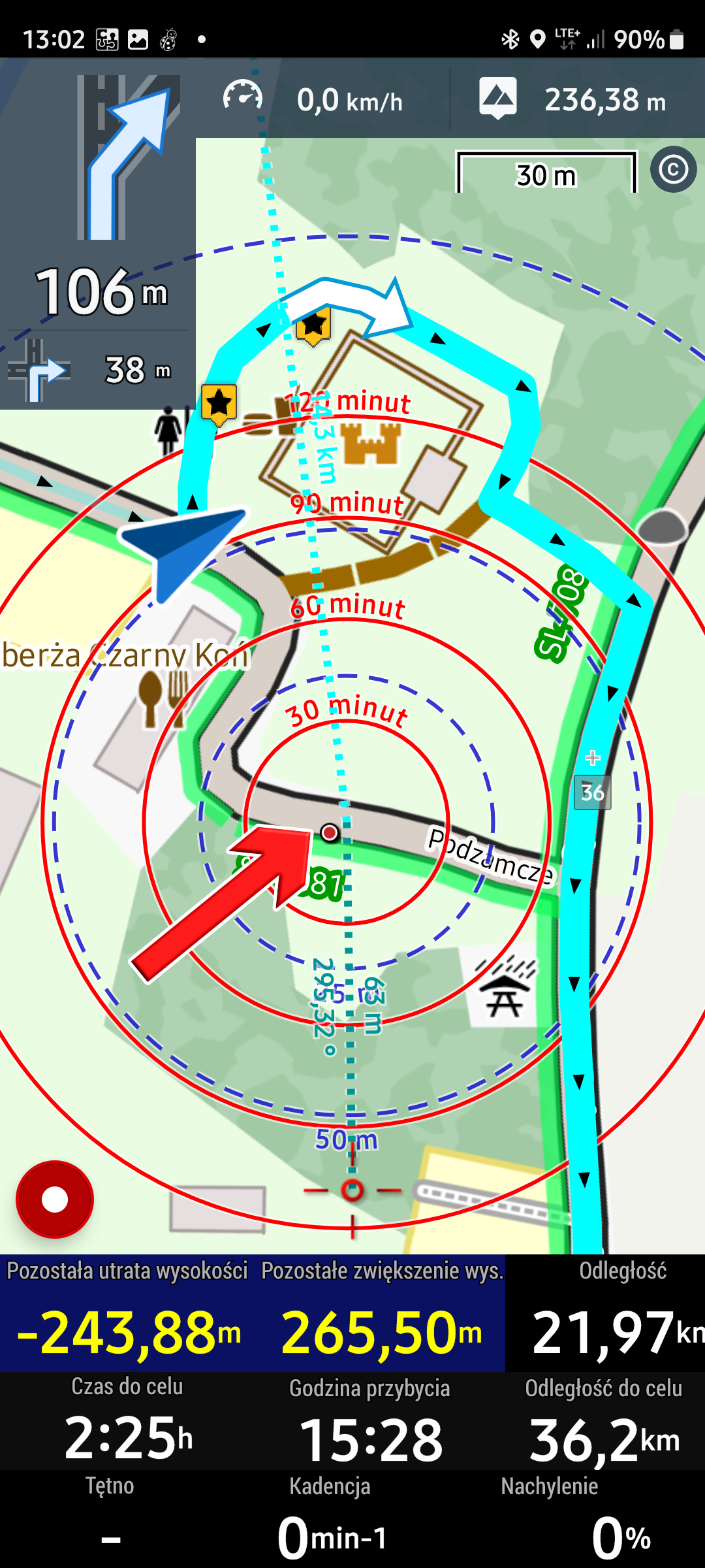
Three updates ago, instead of the recording point, a red arrowhead was displayed (I downloaded the set from the Locus store). It was ok, because the arrowhead is visible,
The point is some kind of misunderstanding, it's invisible on the screen, and when it's still sunny, it's a disaster.
I'm uploading photo 0 - where I had to make a detour (I had 3 detours on this route), the problem - where I am now on the map, and I don't have much time!!!
If there's a problem with this, make options where you can define the recording point, just like you can define the navigation cursor, and it will be OK.
Waldek
Files:
pic0.png
 The same problem
Hi Waldek,
this state is a result of the following:
- you have "Snap to route" option active in the navigation settings - this shows navigation cursor even though you have deviated from the route a bit and your current location is hidden. If you always want to know where you actually are, turn this off (but don't be surprised when there are two cursors visible during navigation - navigation cursor + location cursor)
- you have "Maximum deviation from the route" set longer than the displayed deviation. If it were shorter, the guiding line would display leading to the original route.
- your map cursor is not in the screen center - re-center it or long-press the centering button to activate the "hold screen center" option and and the cursor will re-center automatically
Hi,
1) I didn't change any settings.
2) situation 3 updates back was OK, when I left the route (detour), my position (and recording) was immediately displayed with a red arrowhead (from the red set from the Locus Store).
3) But when I was on the route: the blue arrowhead of the navigation covered the red arrowhead of my position (and recording).
4) Currently, instead of the red arrowhead, I have the point of my position and that's not OK.
5) I would understand your comments if I "messed" in the settings, but I didn't change anything.
6) if there is an option to set the navigation cursor, why can't there be an option to set the cursor of the position and recording?
waldek
Please create a backup of your settings in the backup manager and send the file for a test.
"6) if there is an option to set the navigation cursor, why can't there be an option to set the cursor of the position and recording?"
- there are two individual sets for navigation and location/recording available. You wrote yourself that you set the "gynta_red" cursors for location and recording.:
Hi,
Only that "Map cursors" - (pic1) applies to the whole set of 6 icons (pic0), and selects the point icon, sometimes changes it to a red arrowhead!?
I will try to apply your comments, maybe it will change something, we will see, it is a beautiful autumn, so there will be a bike route.
I have one more question:
- when I am "off-route "(detour), could a line leading to the navigation cursor appear from my current location. It would also help to quickly localize - where I am and where I need to go.
Because I think that neither "Cursor line to position" nor "Direction line" nor "Guide line" meet this.
waldek
"Map cursors" - (pic1) applies to the whole set of 6 icons (pic0), and selects the point icon, sometimes changes it to a red arrowhead!?"
- when Locus Map detects no motion, the location indicator is a circle. When there's a motion, the location indicator changes into an arrowhead.
"when I am "off-route "(detour), could a line leading to the navigation cursor appear from my current location. It would also help to quickly localize - where I am and where I need to go."
- the connecting (guiding) line appears when your location moves out of the set "maximum deviation" distance. In your case reported on 21/10, during navigation, the blue navigation indicator covers the motion indicator. When you deviate from the route and you are within the distance Locus Map needs to switch to guidance + "snap to route" is active, the location indicator is invisible. When you move beyond the "maximum deviation" limit, the location/movement indicator appears together with the guiding line. In my case the "maximum deviation" distance is set to 50 m:
Hi,
I have these settings (now):
1) route priority > distance to recalculate 50 m.
2) Maximum deviation from route > 30 m.
3) Strict route navigation - off.
4) Snap to route - off
5) "Off route" notification > Warning distance = 30 m
I've already received this data from you.
Waldek
P.S.
You have a lot of experience using Locus, maybe it would be worth sharing your settings.
I have almost the same configuration:
1) route priority > distance to recalculate 50 m.
2) Maximum deviation from route > 26 m.
3) Strict route navigation - off.
4) Snap to route - on
5) "Off route" notification > Warning distance = 30 m
I have almost the same configuration:
1) route priority > distance to recalculate 50 m.
2) Maximum deviation from route > 26 m.
3) Strict route navigation - off.
4) Snap to route - on
5) "Off route" notification > Warning distance = 30 m
Hi,
because I got them from you about a year or two ago
waldek
Hi,
because I got them from you about a year or two ago
waldek
Replies have been locked on this page!