Spike-noise in recorded track elevation while paused
I've unfortunately switched from a phone with pressure sensor to one without. Progress? No. After experimenting a long time with GPS "optimize GPS values" and filtering:( no | light | medium | heavy), Even with typically 38 satellites and 2m horizontal accuracy, I switched to "replace GPS values". This generally results in less vertical noise/ jitter in the recorded track elevation. However while the track recording is paused I often notice really bad elevations, today being an example of the worst.
track recording https://link.locusmap.app/t/maoar4
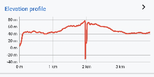
Here is the LM4 (Android) elevation because the web planner elevation doesn't show negative values for some reason (bug). I paused at 2km (half way) and clearly/ logically the elevation should remain close to 60m while stationary.

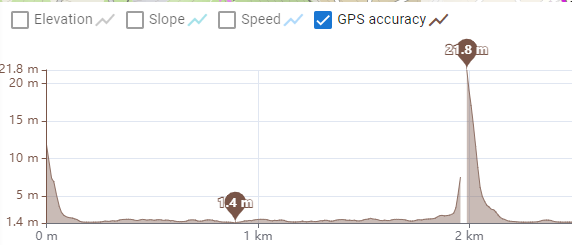
Here is the GPS accuracy. +/-22m of positional jitter. Why is this level of jitter sufficient to cause a huge change in calculated elevation given that the values are derived from SRTM data & GPS elevation is ignored? "replace GPS values" is set. The land around this pause location is relative flat, so even moving the position +/-200m will not result in a significant change in elevation, and certainly not -40m!!

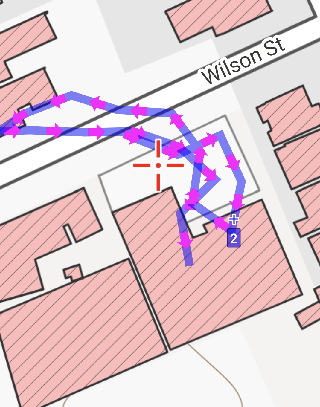
The notional position when paused inside building seems quite reasonable:


 The same problem
Hello Andrew,
these negative peaks happs to you (almost) always when you stop for a moment? Interesting.
Best to do something with it >
If problem happen, track shared over our web portal + recorded log file > I may exactly see when and what comes from the system and probably simulate this problem. Thanks.
Btw. there is currently no Beta version as 4.27 version is published and awaits validation by the Google. But new Beta will be for sure in the end of this week.
Replies have been locked on this page!