
Mark Closed or Restricted Paths on the Map
Completed
Hello,
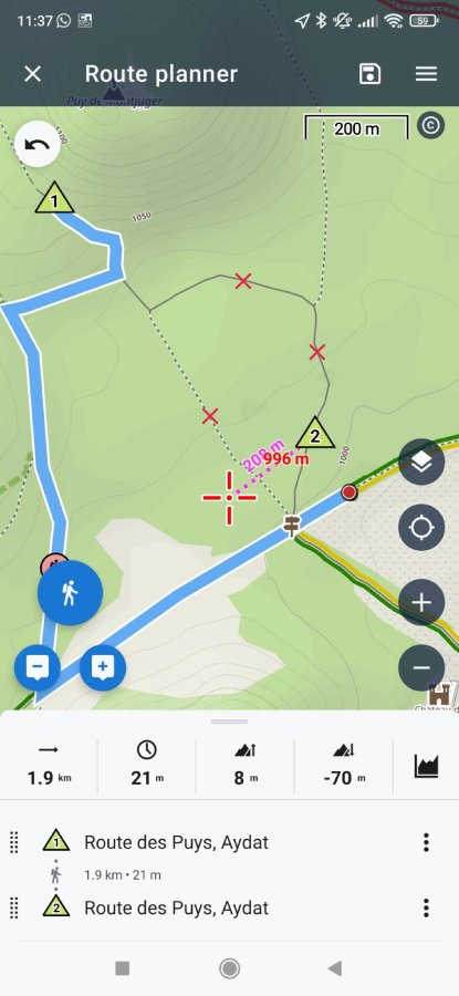
When using the planner with a routing profile enabled, I sometimes notice the route takes unexpected detours. This usually happens when I try to build a track that crosses a closed or with OSM property access=private path.
It’s a bit confusing, since these paths are still visible on the map, but the planner avoids them without any clear indication as to why.
It would be really helpful to display a symbol or marker directly on such paths to show that they’re restricted or not routable - so users know why routing avoids them (or just don’t display them on the map).
See attached video to see the behavior.
Suggested display (sorry I'm a backend developer 😅) :
Thanks for considering this suggestion!
Files:
signal-2025-07-...
 I like this idea
OAM maps have crosses on these paths, depending on the restriction.
Residents only blue
Private yellow
Not allowed red
You can see this in the legend.
OAM maps have crosses on these paths, depending on the restriction.
Residents only blue
Private yellow
Not allowed red
You can see this in the legend.
Some closures, e.g. of roads and paths, are shown on OSM maps using colours/patterns, but how do you imagine that? Depending on the profile (on foot, by bike, by car, etc.), there are many different types of closures and restrictions. Bollards, closed gates, crowd barriers, traffic rules, different access permissions etc. It's impossible to display all these things on the maps, nor should it be.
In addition, there are individual settings in the routing profiles. Some people want to ride their bikes over stairs, others don't want to under any circumstances. Furthermore, your routing data may be older or newer than the map used.
I don't see a problem here. If the router doesn't take you there, you can quickly check OSM to see why. If you still want to route via blocked or unauthorised paths, you can use a profile that ignores such restrictions (e.g. the one from Zossebart).
Thanks for your input on this. Personally, I use LoRouter (both online and offline) to plan my hikes. I’ve noticed that the router behavior is already influenced by these path attributes (like private access or closures) since it prevents routing through those segments. As you mentioned, this likely depends on the specific router and its configuration.
That said, my point isn’t about changing how routers handle such paths. Instead, I’d love to see a visual indicator on the map itself to highlight this kind of information. It’s quite inconvenient to have to cross-reference OpenStreetMap manually, especially when planning a track on a mobile device.
For example, I find Komoot's map very helpful in this regard, whether for hiking or cycling, because it clearly displays this type of path information at a glance :
This is also shown in the oam maps. Unfortunately, there is no information about whether the gate is closed or passable. In the normal map, you can quickly switch to OpenStreetMap via Favorites. But this feature isn't available in the route planner. That's a real shame.
This is also shown in the oam maps. Unfortunately, there is no information about whether the gate is closed or passable. In the normal map, you can quickly switch to OpenStreetMap via Favorites. But this feature isn't available in the route planner. That's a real shame.
Here is a picture of how goals are displayed in OAM.
Here is a picture of how goals are displayed in OAM.
Thank you for an idea. To be honest it sounds more like a problem. We'll improve it!
Thank you for an idea. To be honest it sounds more like a problem. We'll improve it!
We’d like to inform you that a new map theme is prepared and improve the visibility of OSM highways tagged with access=private or access=no. These changes will be included in the next version of the Locus Map app for offline LoMaps. For online maps, updates should be available within the next two weeks.
Thank you for the idea
Great
Thanks
Great
Thanks
Hi Petr, great news, thanks a lot for this improvement ! I'm looking forward to testing it !
Hi Petr, great news, thanks a lot for this improvement ! I'm looking forward to testing it !
This feature is a great improve to understand why the router does not want to do a route through some tracks or paths.
But at some zoom levels, the icon is not big enough, and I do not understand that router can not do it.
- At zoom 15, icon is not shown.
- At zoom 16 and 17, icon is a lot too small.
- At zoom 18, icon is la littel bit too small.
Is it possible to increase the icon size ?
Please how to put several pictures on the same row ? I did not understand.
Please how to put several pictures on the same row ? I did not understand.
Replies have been locked on this page!