
Bottom of screen map controls missing for many recorded tracks
Answered
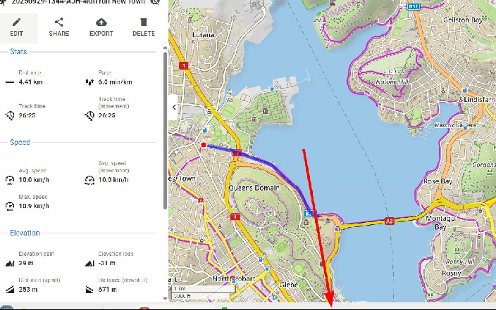
Where have the bottom of screen map controls & chart gone for many of my recorded tracks? For example https://link.locusmap.app/t/1dj9o4. The exported GPX files look OK with a text editor. They have only very recently shown this behavior.
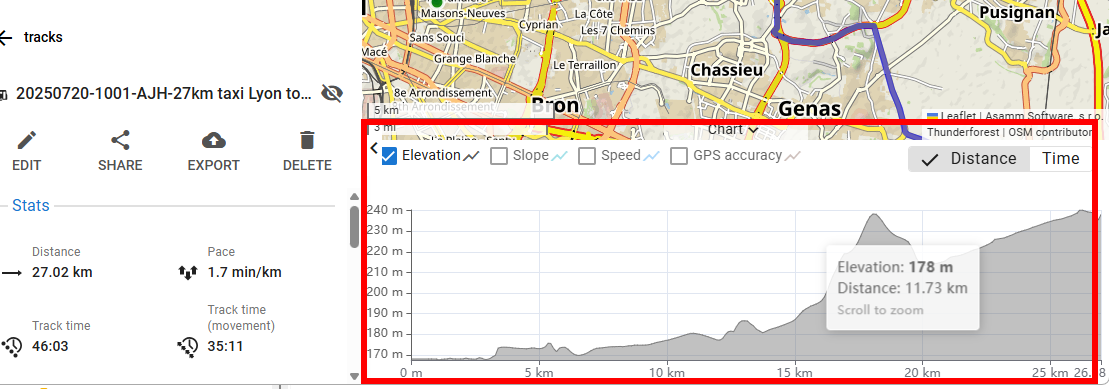
Normal controls & chart as shown below. It seems mostly older tracks are OK:
I imported a few GPX into Garmin Basecamp & can't see any issues. And, I'm pretty sure some of the recorded tracks I checked for this post were previously showing the chart anyway. I don't see any recent WebPlanner version change. Of course, I tried ctrl+F5.
 The same question
More info. Recorded tracks before 2/9/2025 are OK. Recorded tracks after this date won't show the chart & associated controls. I simply clicked on each track from in order one folder until the chart changed, so it isn't very scientific, but supports my initial experience that something in the WebPlanner is not working, maybe around this date. It doesn't related to any release notes though:-
More info. Recorded tracks before 2/9/2025 are OK. Recorded tracks after this date won't show the chart & associated controls. I simply clicked on each track from in order one folder until the chart changed, so it isn't very scientific, but supports my initial experience that something in the WebPlanner is not working, maybe around this date. It doesn't related to any release notes though:-
Hi Andrew, what do your tracks recorded after 02/09/2025 look like in the Locus Map app? Do they contain an elevation chart? I've imported the track you posted to my Locus Map and there is no chart either because the track doesn't contain elevation data.
Hi Andrew, what do your tracks recorded after 02/09/2025 look like in the Locus Map app? Do they contain an elevation chart? I've imported the track you posted to my Locus Map and there is no chart either because the track doesn't contain elevation data.
Hi Michal. The track shared via the link has ELE in the exported GPX & in native Android LM
From the WebPlanner, good & bad tracks "look" the same on the main map to me. Just lacking elevation.
The elevation profile on Android LM 4.31.3.5 looks OK too. Comparing 2 GPXs in notepad tabs, side by side, the header <?xml... is identical & basic <trkpt>...</trkpt> structure is OK. Even without elevation data, there is also heart rate data that the chart can display.
#2 - A manual upload of GPX file containing valid elevation data, from recorded track at start of this year, from Windows PC via Web Browser also fails to display a chart.
#2 - A manual upload of GPX file containing valid elevation data, from recorded track at start of this year, from Windows PC via Web Browser also fails to display a chart.
Thanks, Andrew, for the additional info and testing. We've been analyzing the issue.
Thanks, Andrew, for the additional info and testing. We've been analyzing the issue.
Andrew, does the track contain elevation data in the Android app? Could you please send a GPX of the track exported from the app? Where (or when) exactly does the elevation data disappear? When you sync the track with the web and share/export it from there?
Andrew, does the track contain elevation data in the Android app? Could you please send a GPX of the track exported from the app? Where (or when) exactly does the elevation data disappear? When you sync the track with the web and share/export it from there?
Hi Andrew,
The issue should be resolved with the latest beta update. I apologize for the inconvenience. To fix the affected tracks, please edit them locally on your mobile device to trigger an update on the server.
Kind regards,
Ondrej
Hi Andrew,
The issue should be resolved with the latest beta update. I apologize for the inconvenience. To fix the affected tracks, please edit them locally on your mobile device to trigger an update on the server.
Kind regards,
Ondrej
Replies have been locked on this page!