
Bad time estimation while using LoRouter for cycle profile touring
I used LoRouter Online to navigate me from 47.92837,7.35812 to 48.003119,7.26396 and it over estimated the travel time by 1/2 or 1/3 depening on what one looks at.
At 13:49 ETA was 15:03 (=74min travel time) but real arrival time was 14:43 (=49min moving time plus 5min break which router shall not take into consideration) so routing engine over estimated by 74/49=51% which is IMHO considerable – it easily makes the difference wheter I do a tour or not. I used profile Touring with "average speed on flat ground" set to 20km/h and the track's average speed while moving is 19,0km/h so I was quite nearby the setting.
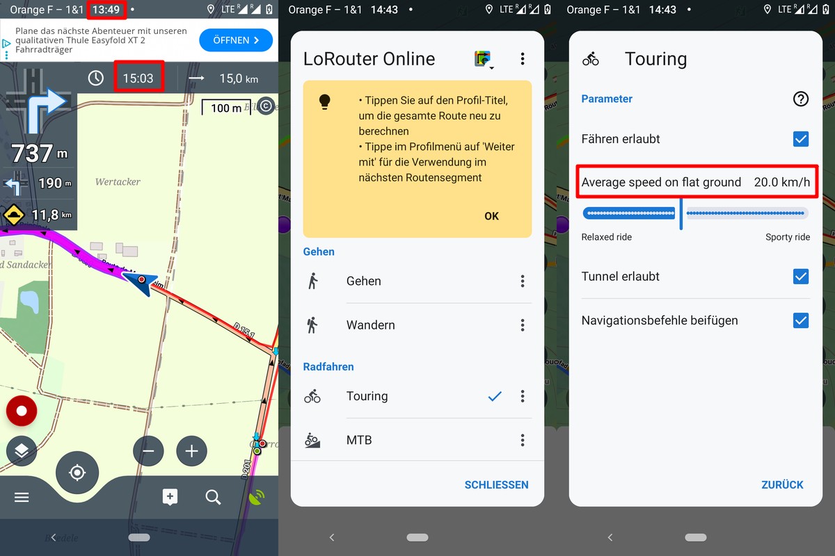
The over estimation is only partly caused by 240m elevation gain over 3,7km uphill distance. For the part containing the uphill portions, LoRouter estimates 42min while I needed 25min, so the conversion from "average speed on flat ground" into watts into "uphill speed" over estimates by 68% – which is discussed in another issue.
For the remaining part, LoRouter estimates 74-42=32min while I needed 49-25=24min so still an over estimation of 32/24=33%. What can cause that and how can we improve that?
Side note: For hiking profile, ETA was very exact during a few tests. So it is not a general issue but limited to some profiles.
 The same problem
Hello Georg. I know you have recently reported similar issue with ETA for cycling. I did look into it. What is going on there: If I say I cycle 20 km/h on flat ground, this speed is converted to wats. This part is working reasonably accurate. Then this power is used for ETA/time calculation. These are calculation done by Brouter authors, not me (us) and frankly I do not see problem at the first glance. Some more work is needed. Most likely some constants (weight of the system for hills factor) are not right. Thanks for reporting, I do not dismiss this issue, it is a problem. Walking: Here the approach is different. We use Tobler hiking function with some Locus-custom extension for surfaces. Anyway thanks for reporting.
Hello Georg. I know you have recently reported similar issue with ETA for cycling. I did look into it. What is going on there: If I say I cycle 20 km/h on flat ground, this speed is converted to wats. This part is working reasonably accurate. Then this power is used for ETA/time calculation. These are calculation done by Brouter authors, not me (us) and frankly I do not see problem at the first glance. Some more work is needed. Most likely some constants (weight of the system for hills factor) are not right. Thanks for reporting, I do not dismiss this issue, it is a problem. Walking: Here the approach is different. We use Tobler hiking function with some Locus-custom extension for surfaces. Anyway thanks for reporting.
Replies have been locked on this page!