
Wrong Statistics wen using web planner
Answered
Hi guys.
I'v enoticed when in track plan/edit mode statistics are different from those when track is saved. See attached file. I'm particulary concerned about huge difference in elevations but difference in distance up and down is also huge. Length of track does not change.
 The same question
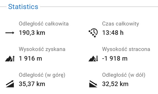
Hi,
In the route planner and edit mode, Locus shows elevation gain calculated directly from raw elevation data (SRTM) sampled at every shaping point along your route. No smoothing is applied at that stage. The raw profile typically contains many small ups and downs caused by imprecisions in the underlying elevation model — and each one gets added to the cumulative gain.
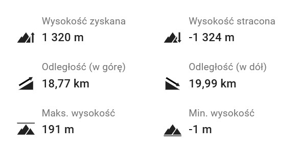
When you save the track, Locus runs an optimization step that filters out this noise to give more realistic statistics. Because the uphill/downhill distance is derived directly from the elevation profile, those values shift alongside the elevation totals — which is exactly why your "distance up" and "distance down" also dropped (from roughly 35/33 km to 19/20 km). The total length doesn't change because it's purely horizontal — the geographic shape of the route is untouched.
What makes the difference look especially dramatic in your case is that this is a very flat route — max elevation 191 m, min −1 m over 190 km. On flat terrain, the small SRTM noise spikes are large relative to the actual elevation changes, so they accumulate into a much bigger raw figure. The 1916 m of "gain" in the planner is mostly accumulated noise; the smoothed 1320 m after saving is closer to reality, though for a route this flat I'd expect even that to still be a slight overestimate — that's a limitation of the SRTM elevation data itself rather than something the app can fully correct.
Hi,
In the route planner and edit mode, Locus shows elevation gain calculated directly from raw elevation data (SRTM) sampled at every shaping point along your route. No smoothing is applied at that stage. The raw profile typically contains many small ups and downs caused by imprecisions in the underlying elevation model — and each one gets added to the cumulative gain.
When you save the track, Locus runs an optimization step that filters out this noise to give more realistic statistics. Because the uphill/downhill distance is derived directly from the elevation profile, those values shift alongside the elevation totals — which is exactly why your "distance up" and "distance down" also dropped (from roughly 35/33 km to 19/20 km). The total length doesn't change because it's purely horizontal — the geographic shape of the route is untouched.
What makes the difference look especially dramatic in your case is that this is a very flat route — max elevation 191 m, min −1 m over 190 km. On flat terrain, the small SRTM noise spikes are large relative to the actual elevation changes, so they accumulate into a much bigger raw figure. The 1916 m of "gain" in the planner is mostly accumulated noise; the smoothed 1320 m after saving is closer to reality, though for a route this flat I'd expect even that to still be a slight overestimate — that's a limitation of the SRTM elevation data itself rather than something the app can fully correct.
Thanks,
Makes sense.
Thanks,
Makes sense.
Replies have been locked on this page!