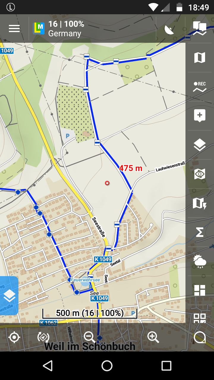
Hello everybody, I'm writing from Germany and I'm new to Locus. My problem is that on the map Lomap Germany are recently blue points. How can I remove the points? What am I doing wrong? Thank you for tips.
as @balloni55 wrote the blue points describe the marked hiking path. It seems that you use default online map (Maps - Online - Outdoor - Outdoors). This map is "static" image and you can not remove them. Please use different online or download LoMap map from Locus Store. You can customize appearance of LoMaps by themes and you can the blue (marked) lines. More about LoMaps how to download and change the theme is described at https://docs.locusmap.eu/doku.php?id=de:manual:user_guide:maps_locusmaps
Thanks, Petr
Hello Herbert,
as @balloni55 wrote the blue points describe the marked hiking path. It seems that you use default online map (Maps - Online - Outdoor - Outdoors). This map is "static" image and you can not remove them. Please use different online or download LoMap map from Locus Store. You can customize appearance of LoMaps by themes and you can the blue (marked) lines. More about LoMaps how to download and change the theme is described at https://docs.locusmap.eu/doku.php?id=de:manual:user_guide:maps_locusmaps
as @balloni55 wrote the blue points describe the marked hiking path. It seems that you use default online map (Maps - Online - Outdoor - Outdoors). This map is "static" image and you can not remove them. Please use different online or download LoMap map from Locus Store. You can customize appearance of LoMaps by themes and you can the blue (marked) lines. More about LoMaps how to download and change the theme is described at https://docs.locusmap.eu/doku.php?id=de:manual:user_guide:maps_locusmaps
Thanks, Petr
Hello Herbert,
as @balloni55 wrote the blue points describe the marked hiking path. It seems that you use default online map (Maps - Online - Outdoor - Outdoors). This map is "static" image and you can not remove them. Please use different online or download LoMap map from Locus Store. You can customize appearance of LoMaps by themes and you can the blue (marked) lines. More about LoMaps how to download and change the theme is described at https://docs.locusmap.eu/doku.php?id=de:manual:user_guide:maps_locusmaps
Thanks, Petr
Hello Herbert,
as @balloni55 wrote the blue points describe the marked hiking path. It seems that you use default online map (Maps - Online - Outdoor - Outdoors). This map is "static" image and you can not remove them. Please use different online or download LoMap map from Locus Store. You can customize appearance of LoMaps by themes and you can the blue (marked) lines. More about LoMaps how to download and change the theme is described at https://docs.locusmap.eu/doku.php?id=de:manual:user_guide:maps_locusmaps
Thanks, Petr
Hello Herbert
by the way, it´s als possible to ask in german forum
https://forum.locusmap.eu/index.php?board=27.0
Your question,
the blue dots mark a hiking path/Wanderweg
the depiction of the map depend on used "vector map" in combination with used "map theme" .
.
I´m not sure you use a Lomap, for me it looks different while using Lomap with theme "Wandern und Radfahren" with activated "Wanderwege"
Wolfgang
Hello Herbert
by the way, it´s als possible to ask in german forum
https://forum.locusmap.eu/index.php?board=27.0
Your question,
the blue dots mark a hiking path/Wanderweg
the depiction of the map depend on used "vector map" in combination with used "map theme" .
.
I´m not sure you use a Lomap, for me it looks different while using Lomap with theme "Wandern und Radfahren" with activated "Wanderwege"
Wolfgang
Hello Herbert,
as @balloni55 wrote the blue points describe the marked hiking path. It seems that you use default online map (Maps - Online - Outdoor - Outdoors). This map is "static" image and you can not remove them. Please use different online or download LoMap map from Locus Store. You can customize appearance of LoMaps by themes and you can the blue (marked) lines. More about LoMaps how to download and change the theme is described at https://docs.locusmap.eu/doku.php?id=de:manual:user_guide:maps_locusmaps
Thanks, Petr
Thanks, i write in german forum
Thanks, i write in german forum
Replies have been locked on this page!