
Download map around points - pixels instead of meters
Gathering feedback
I realise that a similar function already exists, but I'd like to propose an additional enhancement. :)
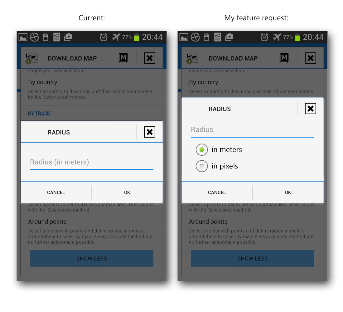
Would it be possible to add additional option to this screen?
 I like this idea
Good day Wojciech,
interesting idea. But please, try to describe me what is a benefit of this solution. I cannot imagine, why some defined pixels of map in every zoom level should be better then metres. With pixels, more I zoom to point, less area around point I'll see. If I define 200 pixels, then in quite common zoom 20, I'll see around 30 metres. Quite useless I think.
I'll give an example.
Let's say I have created a folder with 7 waypoints - in very different parts of the world. I want to a be able to zoom in, to each of these points, while being offline. In other words, when I'm offline, and any of these points is inside my phone screen, I'd like the map around this point to be available too - regardless of the current zoom level.
However, note that the current radius parameter (in meters) is not what I need. The distance from the center to the edge of my screen depends on the zoom level - e.g.:
* when I use zoom level 19, I'd like 250 meters around the point downloaded,
* but, when the zoom is 18, I want 500 meters downloaded,
* for zoom 17 it is 1000 meters,
...
* for zoom 11 it is 64000 meters, and so on.
Which one of these values should I enter in the "radius" parameter? If I enter 250 meters, then Locus will download only a single tile for zoom level 11:
However, if I could enter the radius in pixels, it would work as I expect. The distance from the center to the edge of my screen is always 200px, regardless of the zoom level. Locus would download ~9 tiles for each of my points for every zoom level. So, even if I select all the zoom levels, the number of downloaded tiles will be small.
Very nice explanation, thank you! I firstly wanted to "decline" this idea at start, but your explanation make sense. So we will see if this will be useful for more people (because It is not a task on a few minutes of work).
Very nice explanation, thank you! I firstly wanted to "decline" this idea at start, but your explanation make sense. So we will see if this will be useful for more people (because It is not a task on a few minutes of work).
I used to use the program neongeo for Geocaching that had a similar feature. For downloading offline maps, it would download one screen worth around each point. So I would always have a map at any zoom level around all of my downloaded caches, but it would require much fewer tiles downloaded than the current mechanism of downloading by distance. The only difference I would make to the original proposal would be to measure it in screens rather than in pixels. Specifying 1 screen would mean that with the point centered on the screen, you would always see a map at any scale; specifying 2 screens would mean that you could see the full map as long as the point was anywhere on the screen, at the cost of 4x tiles.
(Neongeo is no longer supported, so I switched to Locus Pro. Except for this one feature, I have found Locus Pro superior in every way.)
Replies have been locked on this page!