
This object is in archive!
External map is offset
Answered
Hi,
I have made a map from TIFF's and TAB data with Mapc2mapc. When i use it in Locus it offsets with the other maps (See navigation screen shot).
How can this be solved?
Also I will have 60 maps like this so ideally not something i have to repeat for every map.
Thanks
Files:
screenshot_offs...
 The same question
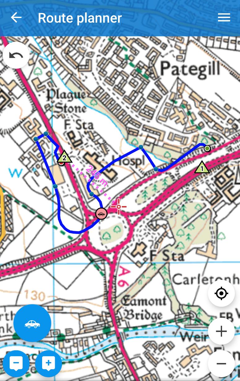
Hi,
I would suggest to check (in first step) the source Tiff. Would you please open source tiff file for example in QGIS SW. Display also any online map, set partial transparency and compare if source tiff file is correctly geo-referenced.
Thanks, Petr
Hi,
I would suggest to check (in first step) the source Tiff. Would you please open source tiff file for example in QGIS SW. Display also any online map, set partial transparency and compare if source tiff file is correctly geo-referenced.
Thanks, Petr
I have compared it with an online map and my current gps position. My external map is definitely offset a few 100m. See the sqlitedb attached and the files i made it from.
I have compared it with an online map and my current gps position. My external map is definitely offset a few 100m. See the sqlitedb attached and the files i made it from.
Hi John,
I compared the tiff file with OSM map and it seems that the problem is caused due to wrong geo-referencing of original tiff file. See attached screenshot and wrong position of coastlines.
Thanks, Petr
Hi John,
I compared the tiff file with OSM map and it seems that the problem is caused due to wrong geo-referencing of original tiff file. See attached screenshot and wrong position of coastlines.
Thanks, Petr
Thank you for looking at this.
Hum, that's offset in the opposite direction to what i see, and not as much.
The referencing is by Ordnance Survey, so im surprised it is incorrect. Can you suggest a way to correct 2500 TAB files? or maybe the 60 merged maps?
Thank you for looking at this.
Hum, that's offset in the opposite direction to what i see, and not as much.
The referencing is by Ordnance Survey, so im surprised it is incorrect. Can you suggest a way to correct 2500 TAB files? or maybe the 60 merged maps?
I would suggest to check again the original OS data. It's really weird that they would distribute inaccurate data and it's also weird that they use MapInfo TAB format. Did you somehow edit the data in MapInfo? Maybe that wrong reference system was used.
You can use Mapc2mapc for georeferencing - see Map Calibration at https://www.the-thorns.org.uk/mapping/help/how.html But I would rather check the original data or contact the OS support. They should define CRS (reference system) for data and any other metadata.
Thanks, Petr
They also supply .TFW but that placed my map in south Africa!
Il keep investigating
They also supply .TFW but that placed my map in south Africa!
Il keep investigating
I'm sorry I can't test - you sent me TIFF file for zone HW63 in the previous post. However as I know OS distributes maps in reference system OSGB 1936 / British National Grid - see https://epsg.io/27700 . Please check if you set correct coordinate reference system tiff/tfw raster (to avoid South Africa issue)
Thanks, Petr
The issue was datum used when making map. Mapc2mapc used WGS84, not "ORD SRVY GRT BRITN" datum.
Thanks to John Thorn from Mapc2mapc for solving this.
The issue was datum used when making map. Mapc2mapc used WGS84, not "ORD SRVY GRT BRITN" datum.
Thanks to John Thorn from Mapc2mapc for solving this.
Replies have been locked on this page!