This object is in archive! 

Satellite maps level curves

Diego Andres Alvarez Marin shared this idea 5 years ago
Completed

Hello,

I wonder if it is possible to implement this:

https://2wlbzf2t7zavst8k2jj7wdz8-wpengine.netdna-ssl.com/wp-content/uploads/2018/12/Screen-Shot-2018-12-13-at-2.18.53-PM.png

in Locus. That program is GAIA GPS. That would be great!


Kind regards,


Diego Andrés

Replies (1)

photo
2

Hello,

basically it's possible to use satellite maps with contour lines but Locus do not offer worldwide satellite map - only for several countries. However there are how to steps (let say for USA):

- display USGS satellite map Map > Online > USGS > Satellite

- download LoMaps map for specific state: Menu > Store > Americas > US > download LoMap you're interestedn in

- the appearance of LoMaps map can be influenced by the themes and it's possible to prepare the theme that display only contour lines. Download attached zip file Countours_theme.zip. Unpack it and copy contact on your device into folder: /Locus/mapsVector/_themes

- Open Menu > More > map overlay > enable overlay and as overlay choose offline map > select downloaded LoMaps

- finally change theme for Lomaps to countour theme: how to change theme http://docs.locusmap.eu/doku.php?id=manual:user_guide:maps_locusmaps#switching_map_themes

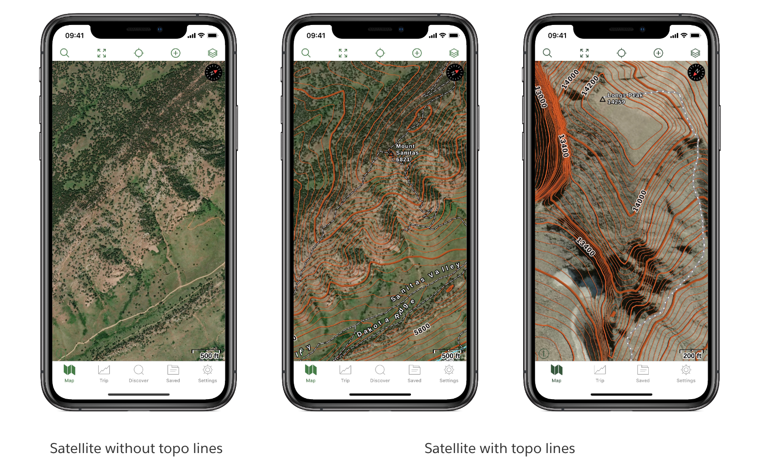
The result is shown on attached image.

Thanks, Petr

photo
2

Thanks Petr, it worked!

photo
1

Hi Petr,

I have also been wanting this map appearance. I've downloaded and put the files into the folder:/Locus/mapsVector/_themes. However, when I try to switch the theme, I don't get any new options beyond the road/ski/hike/bike themes. I restarted Locus thinking that this might do the trick, but it didn't:/

It's likely something obvious, perhaps one of you know what I'm missing?

Thanks,

Ernest

photo
1

Hi Ernest,

what map do you use, please? Did you download the LoMaps from Locus Store, please?

Thanks, Petr

photo
1

Hi Petr,

Yes, Using the LoMaps (from the Locus Store, Offline, British Columbia) as the overlay on top of a satellite image.

After not having luck using this approach, I've been trying to just use the layer with the different blending modes, but the results have shown to be rather unstable/unusable. -But this is beside the point, as I'm trying to get this new theme as you outlined above.

And thank you for the quick reply!

I'm not trying to complain - I love Locus Maps!

Cheers,

Ernest

photo
1

Hi,

thank you for the info. I tested the theme and it works correctly. Please try to download it again. Unpack/unzip it and copy the content into folder /Locus/mapsVector/_themes. After that restart the Locus, select the LoMaps, and check the themes.

Thanks, Petr

photo
1

Hi Petr,

So I did as you suggested and it works! Thank you. It must have something to do with my having extracted the .zip file on my computer and then putting the files in the /Locus/mapsVector/_themes folder, as this time I did it all on the phone and, with restart, it works.

I must say that it is a little glitchy though. The map layering (even base map) changes seemingly randomly based on location and magnification. It's strange - like some areas show up as a map that isn't even turned on - but is one of my offline maps. In other areas and magnifications, the base layer vanishes completely. I don't have the time right now to get too specific right now, and can live with this as is. I'll attach a couple screenshots to give you a sense of what I'm seeing.

I really like the contour theme, and it's ability to extract just the isocurves.

I will continue to play with it to see if I can make better sense of what's happening.

Otherwise, I realize that this is a workaround and not built into Locus at its release state, so these glitches are fully understandable.

Thanks again,

Ernest

photo
1

Hi Ernest,

I'm not sure what map do you use. It's probably some combination of BRMB and some older downloaded online map? Anyway, it doesn't seem you use the LoMaps with the contour theme. Please try the following steps:

  • Open Menu > More > map overlay > disable overlay (to be sure that there isn't any other combination of overlayed maps)
  • Menu > Maps > Offline > Americas > select your offline LoMaps
  • Change the theme and select the contour theme > you should see only contour lines with white background
  • Open Menu > Maps > Online and select for example OSM Others > OSM classic (the goal is to select any map that doesn't contain contour lines)
  • Open Menu > More > map overlay > enable overlay > select offline maps > BC LoMaps
  • You should see the map with contour lines.

Thanks, Petr

photo
1

Hi Petr,

I've attached some pictures that will help to explain what my settings are, and what I'm seeing. The BRMB showing up is puzzling to me, as it's one of my offline maps, but it's not selected. Anyway, here's some screenshots that might be helpful.

Thanks,

Ernest

photo
1

Hi,

in the first step, please try to change the following settings:

Menu > Settings > Offline Maps > Rater Maps > Automatic map loading > and select "No map auto-load". It seems that you have multiple offline maps that overlap each other and auto-loading causes problems with loaded BRMB vs Sattelite map.

Thanks, Petr

photo
1

That's got it Petr! Thank you so much!


-Ernest

photo
1

great, thank you for the info.

Petr

Replies have been locked on this page!