
This object is in archive!
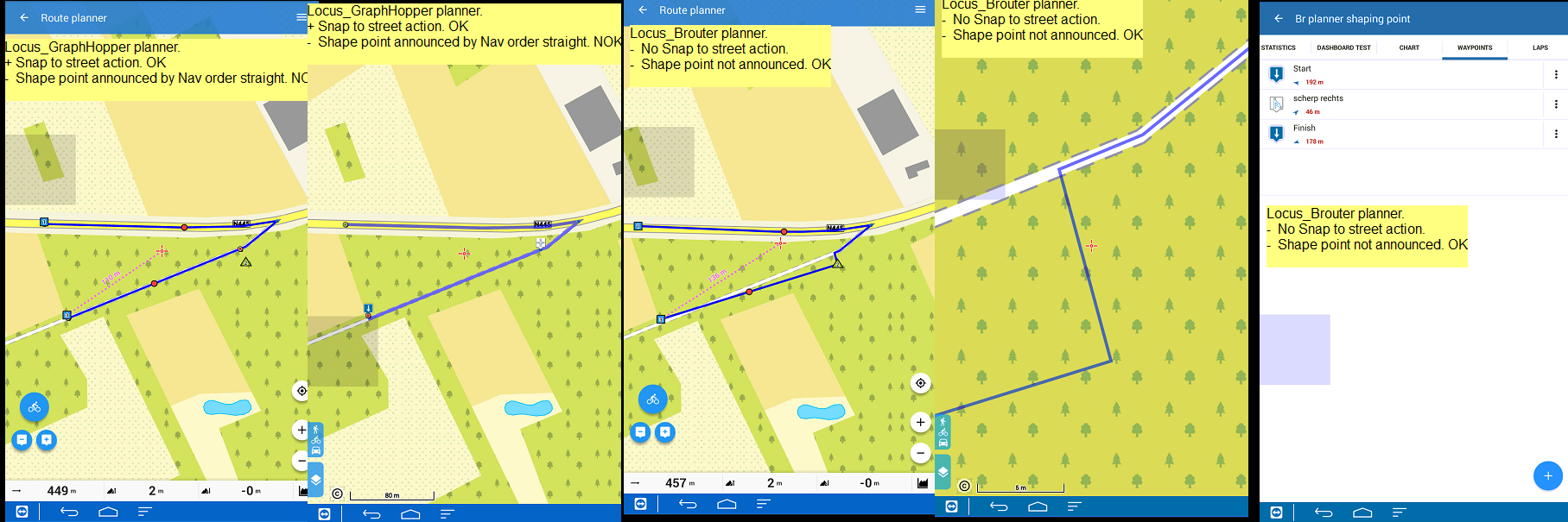
Shaping points by Locus_GH planner are announced at navigation.
Solved
Close Planner, shaping point job finished , should not inject commands into a finalised route.
- Shaping point by Locus_Brouter planner at navigation has no function so is not announced. (OK)
- Shaping point by Locus_GraphHopper planner at navigation are announced by nav_order " straight". (NOK).
More info see attachment. The shaping point was misaligned for a best demo compare.
Info: The resulting track by GH generation is without 'kinks" by GH's "snap to street" action. Compare with the BR result.
Files:
Shaping point a...
 The same problem
Hi Willy,
I simulated the problem - shaping points with GraphHopper generate navigation commands. We'll have a look at it.
Hi Willy,
I simulated the problem - shaping points with GraphHopper generate navigation commands. We'll have a look at it.
Thanks Willy,
issue should be fixed now. I've also temporary disabled small hack I made in BRouter router (to fix some previous not working segment-merging). So check also "snap to road" by BRouter in next version, thanks!
Menion
Thanks Willy,
issue should be fixed now. I've also temporary disabled small hack I made in BRouter router (to fix some previous not working segment-merging). So check also "snap to road" by BRouter in next version, thanks!
Menion
V 3.29.2.3
GraphHopper issue: No change..not solved ?
Brouter: "Snap to street" OK.
Q1: In the planner !
- From a "snap to street" traject towards a manual drawn traject (off street) a connection line is shown.
- From manual traject towards next "snap to street" traject there is surprisingly a (small) 'gap' in the design path line. (No problem but good to know)
After save result : Resulting track is complete and correct : no gap. Reopen in the planner: no gap. Navigate corrrect.
Q2: In the planner !
- How to add a Nav point in the manual drawn section precise on top of a (cornering) shaping point ?
- In previous versions: After save track result by the track editor function : "convert to navigation point".
(Function not offered in new actual track editor)
Good morning Willy,
sorry for a late response. I was almost sure that issue is fixed, that I've forget to answer. And you are right, it still don't work as expected. So next version ;)
Q1: small gap. Well if it is not there after save, all is good :).
Q2: tap on saved track > route planner and here add your navpoints > save
Replies have been locked on this page!