
This object is in archive!
Great problem
Closed
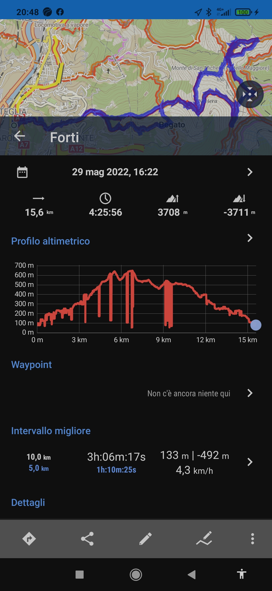
Good evening. I made the gold subscription but I have serious problems in registering outdoor routes (hiking). During the recording of the route (this happens very often and on several mobile phones) the altitude level goes up and down, incorrectly. This then affects the height difference of the excursion. I have tried to change the various settings without success. I add that the GPS signal remains present for the entire duration of the excursions. I would be immensely sorry to have to discontinue the application and have to use another one. But this is really annoying behavior that should never show up. Thank you
Files:
Screenshot_2022...
 The same problem
GPS elevation caught by smartphones is very inaccurate - that is physics, not app effect. No place to hide ...
But you can apply "filter"ing in Locus (kind of averaging). Or you can make Locus correct the elevation data of a track based on SRTM/LIDAR data.
GPS elevation caught by smartphones is very inaccurate - that is physics, not app effect. No place to hide ...
But you can apply "filter"ing in Locus (kind of averaging). Or you can make Locus correct the elevation data of a track based on SRTM/LIDAR data.
PS: the drops in your screenshot are EXTREME, though. The SRTM/LIDAR correction will fix that, but filtering most probably will not.
You should switch on NMEA logging (that is the GPS raw data from the Android level) and look into this data for further insights.
PS: the drops in your screenshot are EXTREME, though. The SRTM/LIDAR correction will fix that, but filtering most probably will not.
You should switch on NMEA logging (that is the GPS raw data from the Android level) and look into this data for further insights.
duplicate of https://forum.locusmap.eu/index.php?topic=7971.msg68000#msg68000 is not good
if you have a built-in pressure sensor/ barometer, this can improve accuracy too; try your tests with a different app but you may likely find the same issues
duplicate of https://forum.locusmap.eu/index.php?topic=7971.msg68000#msg68000 is not good
if you have a built-in pressure sensor/ barometer, this can improve accuracy too; try your tests with a different app but you may likely find the same issues
Replies have been locked on this page!