
Hi,
I have to come back to this problem again.
The answer was that this is not a Locus problem but a BRouter problem.
What's the problem: if there are overlapping sections on the route and there is a turn, the Locus navigation does not see it and there is no message (Picture_2_LM).
I have been investigating the topic for almost a month.
I did the routes on the Locus Planner Web - for all the above situations the Locus failed - there was no news.
On the forums I found people who have already notified you about this error,
but it turns out that they too were left unanswered.
So what about this problem?
Waldek
This object is in archive!
No turn message in navigation
Not a Problem
Hi
it is increasingly common for the navigation to not provide turn announcements.
I am giving an extreme example, because the turn is 90 degrees from the route I drove on 10/07/2022, and it was already the 2nd turn, where there was no message. But there are also messages about a turn when it is not there.
Waldek
 The same problem
Hi,
- is the route planned in the Locus route planner or is it imported?
- what router do you use?
- do you have the navigation commands turned on in settings > Navigation > Advanced settings > Frequency of commands (medium or high)
Hi,
- is the route planned in the Locus route planner or is it imported?
- what router do you use?
- do you have the navigation commands turned on in settings > Navigation > Advanced settings > Frequency of commands (medium or high)
I always use BRouter-Web for route creation and from there I download .GPX file which I import to Locus.
And somehow so far there have been no problems.
The number of messages is high.
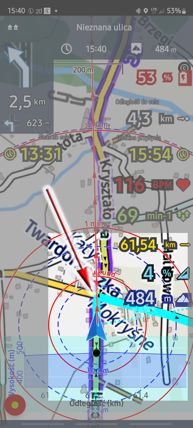
Note that there is no white arrow showing the right turn in the figure I have posted.
Waldek
I always use BRouter-Web for route creation and from there I download .GPX file which I import to Locus.
And somehow so far there have been no problems.
The number of messages is high.
Note that there is no white arrow showing the right turn in the figure I have posted.
Waldek
If BRouter does not create hints, Locus cannot make announcements. The error probably lies with BRouter or in the OSM data.
Try to create the same route in the route planner in the Locus app.
Places with U-turn is often an operator error. If the point is created shortly after the intersection (but in the wrong direction). Locus detects such errors in the route planner and makes a red circle around it.
You can also try Locus WEB planner once.
Hi,
this is probably a problem of BRouter. Locus web planner generates the right turn correctly:
Hi,
this is probably a problem of BRouter. Locus web planner generates the right turn correctly:
I will say this,
For now, your Planner is a baby to an adult BRouter, and you shouldn't be offended by it. Moreover, OSM - this is what Brouter uses and I guess ... I'm not mistaken and Locus, right?
By the way, I would like to know what Planner will shock me with in the future, because so far it is one of many routings.
Waldek
Nobody is offended. LoRouter in the app and in the web planner uses OSM data too. Use any router you want but the only one we can do anything with is LoRouter.
Nobody is offended. LoRouter in the app and in the web planner uses OSM data too. Use any router you want but the only one we can do anything with is LoRouter.
CHi,
I made a route through the intersection (as it was in the attached drawing) in the bikerouter (BRouter clone) and in the Locus Planner. In both cases, navigation was ok.
From this conclusion: navigation does not have to be trusted.
Hence, the map is still visible on my bike, and when hiking in the mountains, I always check the direction of the route at the forks.
waldek
I always check the map, too. There are often 2 ways right off. So I see which one. When cycling I have the phone on the handlebars. Screen turns on and off automatically when announced. I have set via Tasker so that when announced briefly zoomed to level x and then back to the old zoom. So I see the intersection more accurately.
I always check the map, too. There are often 2 ways right off. So I see which one. When cycling I have the phone on the handlebars. Screen turns on and off automatically when announced. I have set via Tasker so that when announced briefly zoomed to level x and then back to the old zoom. So I see the intersection more accurately.
Such various interesting solutions should be generally available on the Locus website, the number of interested parties will certainly increase
Such various interesting solutions should be generally available on the Locus website, the number of interested parties will certainly increase
If a road is in OSM as not passable and they know but so they can drive. Or if no path is marked at all, but they want to drive there. Then you can set the router at this point to manual. A turn instruction they have to create manually. Simply convert a shaping point as a waypoint and name it there. This name will then come as a voice hint.
If a road is in OSM as not passable and they know but so they can drive. Or if no path is marked at all, but they want to drive there. Then you can set the router at this point to manual. A turn instruction they have to create manually. Simply convert a shaping point as a waypoint and name it there. This name will then come as a voice hint.
BRouter has a nice "no-go" option - I set the radius and routes avoid it.
Maybe the option from navigation >> "Add a ban" should behave like that.
BRouter has a nice "no-go" option - I set the radius and routes avoid it.
Maybe the option from navigation >> "Add a ban" should behave like that.
There are many paths on the map that can be seen as passable. In fact, it turns out that they are impassable (overgrown forest road, dug road, etc.). After routing, I do not know about it, only when I go it turns out that there is a problem.
And a detour must be found quickly.
And it should be like this.
I show this point as impassable. Then I show the waypoint which should be OK and the navigation should tell me to detour to it.
Hi,
I am coming back to the problem because I have reconsidered the problem.
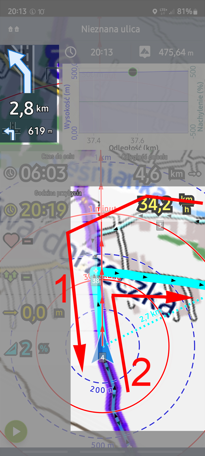
1) It turns out that neither BRouter (Picture_1) nor Locus (Picture_2 - the route marked in the Planner) can see the right turn.
2) This problem occurs in this case, i.e. this straight section coincides with the same route (Picture_2 point 1) when I was returning - point 2.
3) there is no problem when the route is without a section - point 1 - then both BRouter and Locus showed a right turn and it was OK. I wrote about it before.
So I'm waiting for a satisfactory answer.
Waldek
Hi,
I am coming back to the problem because I have reconsidered the problem.
1) It turns out that neither BRouter (Picture_1) nor Locus (Picture_2 - the route marked in the Planner) can see the right turn.
2) This problem occurs in this case, i.e. this straight section coincides with the same route (Picture_2 point 1) when I was returning - point 2.
3) there is no problem when the route is without a section - point 1 - then both BRouter and Locus showed a right turn and it was OK. I wrote about it before.
So I'm waiting for a satisfactory answer.
Waldek
Replies have been locked on this page!