
Lomaps Hungary much less detailed V4 Update
Since I updated LoMaps Hungary V3 to V4 everything is much less detailed.
Hiking signs are not visible at magnifications above 200 metres, below 100 metres they are displayed in text (I think its so unnecessery, if i go to hike, i would like to see only the marks).
There is a lot of overlap between signs and the waymarking is much clumsier.
Here is a compare between old and new map:
Unfortunately I could not take more pictures because I cannot downgrade to the older map.
If locus will share with me the old (V3) map + theme combination I will be happy to take comparison photos.
I have made some comparison pictures with the "Huntura mapsforge" map, which looks like the old Locus V3 map in appearance and detail. But unfortunately it does not show the hiking trails.
I attached some photos as examples. I would really like to get the old map back.
 The same problem
Thank you for your answers!
Technical Question:
It is possible to restore the old V3 map (and it's theme)? I don't create backup file.
Personally I would use the older version until the new version becomes more improved.
Thank you for your answers!
Technical Question:
It is possible to restore the old V3 map (and it's theme)? I don't create backup file.
Personally I would use the older version until the new version becomes more improved.
Some information: For comparison I used the locus built-in hike & bike theme.
Some information: For comparison I used the locus built-in hike & bike theme.
Some information: I tried to reinstall from scratch, with new user. the problem still the same.
It seems like the built-in theme optimized for LoMaps V3 is not really compatible with the new V4 version.
Some information: I tried to reinstall from scratch, with new user. the problem still the same.
It seems like the built-in theme optimized for LoMaps V3 is not really compatible with the new V4 version.
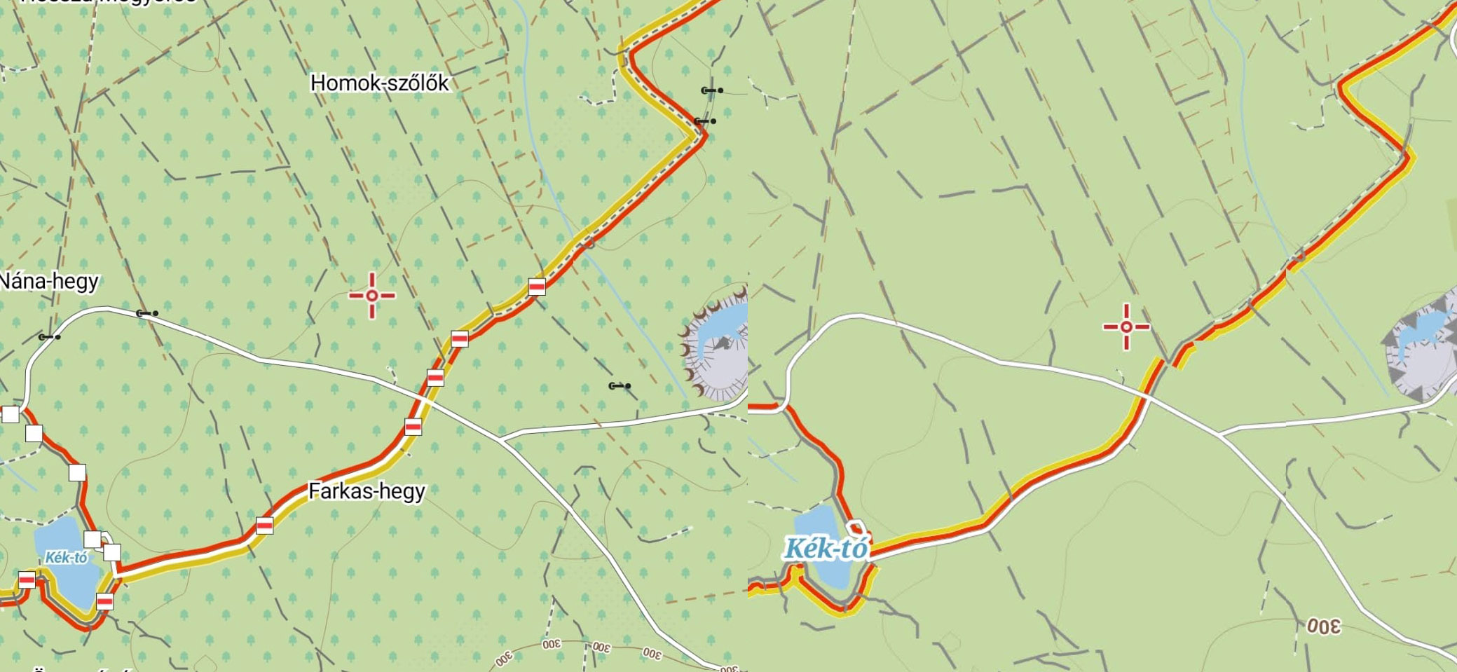
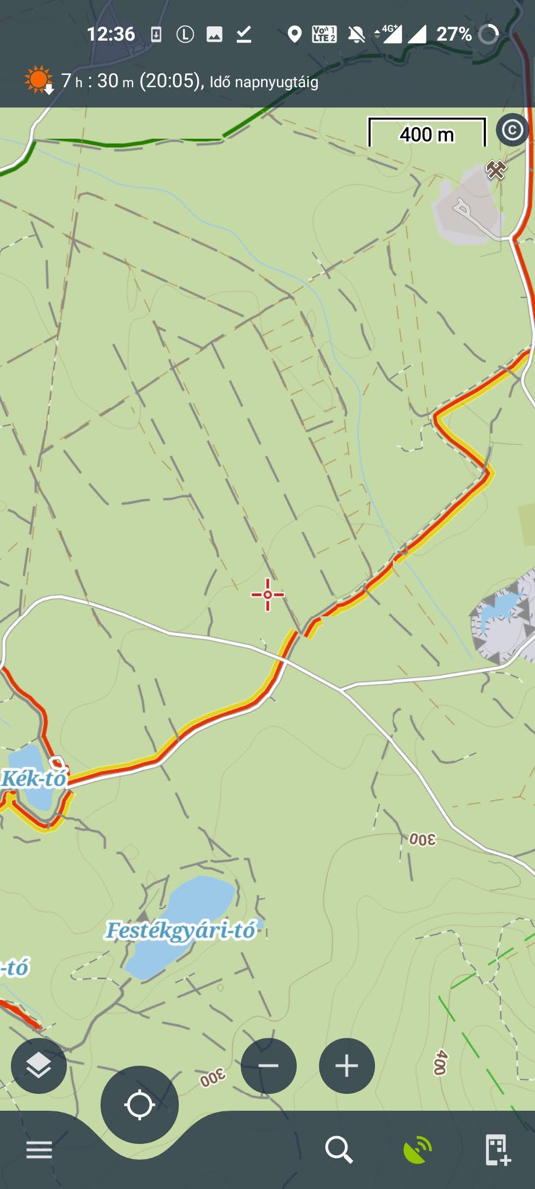
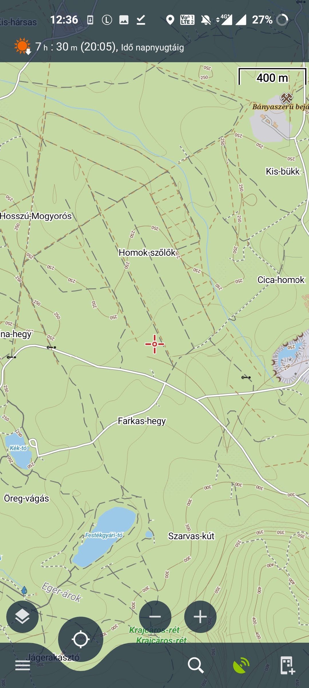
I upload more comparison photo.
It can be seen that the Huntura map (just like old LoMaps) is much (much, much much) more detailed and optimised than LoMaps V4. Name of roads, places, overall detail was better. Text editing is also terrible.
I upload more comparison photo.
It can be seen that the Huntura map (just like old LoMaps) is much (much, much much) more detailed and optimised than LoMaps V4. Name of roads, places, overall detail was better. Text editing is also terrible.
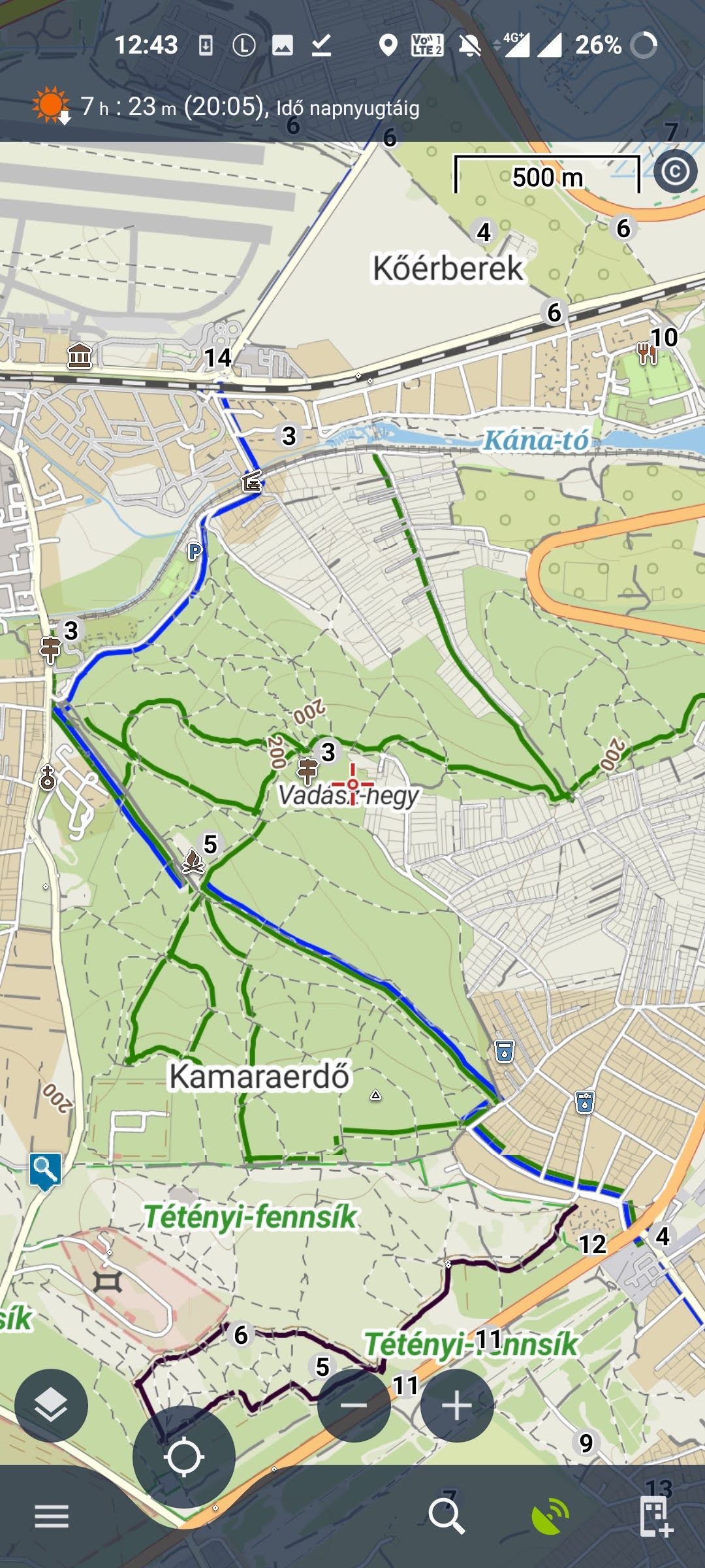
And here's the problem with the trail sings.
On the map, you have to zoom in to 200 meters to see the signs. But if you zoom in further than that, you can see the hiking trails in text. Which is useful from one side, but basically "in the field" I'm only interested in the markings.
I think it would be useful to put this on a separate layer that can be turned off. (I'd certainly turn it off.)
For comparison, here is the Hungary hiking trails (TuraReteg.sqlitedb) overlay. Simple but great, easy to follow signs.
I've noticed this right away, this is going to be a problem for most hungarian hikers i think. Best is not to upgrade to v4 for now.
I've noticed this right away, this is going to be a problem for most hungarian hikers i think. Best is not to upgrade to v4 for now.
Thank you for the message. LoMaps V4 has a completely new style/theme, but almost all data should remain available in V4. Zooming can vary really little depending on the device and resolution. However, the primary goal was to unify with online LoMaps.
The name of a hiking route can be crucial for users in Germany/Austria as it contains a "mark" (character) that cannot be rendered as part of the symbol due to technical limitations. Anyway, we will try to improve this and set the symbols to a higher priority to avoid the problem you mentioned.
From our point of view, the symbol is only additional information about the route, when the route is primarily marked by color which is visible from lower zooms. Can the colour of the route be enough for you to plan?
Thanks, Petr
Color isnt always enough, since there are often 2 or 3 paths nearby intersecting with the same color but different symbols. Attached a picture with 3 different red paths (cross,triangle,stripe) and these symbols have a meaning, a triangle indicates the path goes to a top of a mountain, a circle indicates a path that goes round in a circle, etc... In hungary routes dont really have names, only these symbols painted on the trees.
Color isnt always enough, since there are often 2 or 3 paths nearby intersecting with the same color but different symbols. Attached a picture with 3 different red paths (cross,triangle,stripe) and these symbols have a meaning, a triangle indicates the path goes to a top of a mountain, a circle indicates a path that goes round in a circle, etc... In hungary routes dont really have names, only these symbols painted on the trees.
Hello Petr,
The main problem is that Hungary have a lot of additional symbol within the 4 main signals (red, blue, green, yellow):
Of coure, we have other not unofficial local signals (like Mária út, Gyöngyök útja). These did not show up on the old LoMaps, but that was not a problem for me.
I will try to explain with some pictures (attached) Locus V4 map: There is a lot of blue colored route. But they are different routes, with different marks.
Another problem:
There is a lot of bug in a new map. I never experienced any wrong markings on the old map, even though I have been using Locus for at least 5 years. Really NEVER EVER had a wrong mark.
The new offline map does not match either the reality or the online locus map. Just look at the attached pictures.
Pic 1 LoMaps V4:
- The blue line is not the "main" blue line, but blue cross.
- The line over "Csór-hegy" marked red. But it's a blue line. Actually not "just" a blue line, but the main hiking route of hungary (National Blue Trail - Kéktúra).
- The "Mátra-nyereg" text seems to be covered something and just showed "tra-nyereg". There's a lot of glitch like this.
- No "Mária út" sign or colored route.
Pic 2 "turistautak" overlay:
This is just the real sings. Blue is blue, red is red, cross is cross. Works fine.
Pic 3 Locus online map from PC:
No markings, but the blue is blue, the red is red. And the "Mária út" trail showed orange.
There is another similar glitch/bug:
Pic2 "turistautak" signs:
- The left trail is a green line, marked "green"
- The right trail is red line marked "red" (and a local line, called "gyöngyök útja")
- The trail between on the downside is "green circle" mark.
Pic1 LoMaps V4:
- The green trail showed black and red line (wtf?)
- The red trail showed red. But It's hard to follow because right-up corner had two red line (red and red cross)
- The "gyöngyök útja" local trail showed yellow. But It's actually not an official yellow line.
The problem is not only with the Hungarian map, but also with the Slovak (and other) map.
Here is a cutout from V3 and V4 at the same height.
LoMaps V3: Much more detail, much more optimized routes. Of course, the marks does'n showed up in 1 km scale, but it showed up 4-600 meter scale. Lot of information, like roads, viewpoints, etc. (offline Lopoints are turned off).
LoMaps V4: Just looks like an unloaded online map. Routes are fragmented, lot of glitches, noadditional informations.
Thank you for detailed testing and commnets! I hope I'll answer all notes:
Pic1 Csór-hegy
- blue line based on the relation https://www.openstreetmap.org/relation/3220410
> The line over "Csór-hegy" marked red. But it's a blue line
You're right. The blue line is hidden because there is also a Regional route https://www.openstreetmap.org/relation/5563755. This route has no defined color, Red color is used as a fallback and this route covers the blue route. We'll check if possible to improve it and prefer the route with a defined OSMC color.
>No "Mária út" sign or colored route.
Well, the route is not rendered because the LoMaps are not able to render the text symbol "M" (also as the old V3). For this reason, also a purple color is missing. We'll try to improve it and display at least the colored line
Pic 2 (Nagymaros)
>The green trail showed black and red line (wtf?)
Green route is again hidden under route https://www.openstreetmap.org/relation/6629995 which doesn't have defined the osmc color. We'll try to improve it.
Black Color comes from https://www.openstreetmap.org/relation/14612939 which is marked as "black" in OSM
> Lot of information, like roads, viewpoints, etc. (offline Lopoints are turned off).
Please turn on the LoPoints. The new LoMaps doesn't contain almost any icons (except gates, ladders) and LoPoints are vital part of the map
Online LoMaps
- is not possible to display the symbols at all
- some colors are not supported (for example mentioned purple for "Mária út")
- frankly, Online LoMaps have a few limitations as not all route data is available. The data used for online LoMaps is managed by another company and it is difficult to influence the structure of the data and also the final appearance of the map.
We'll try to solve the problem when another route is hidden under the local route. We'll also consider moving the symbol one zoom level higher. I can also see that there are several/special symbols that aren't defined in our themes. Unfortunately lot's of these symbols are text (character) and it's really complicated for us to display the text symbols in symbols :/
Thank you for your answers!
Technical Question:
It is possible to restore the old V3 map (and it's theme)? I don't create backup file.
Personally I would use the older version until the new version becomes more improved.
Thank you for your answers!
Technical Question:
It is possible to restore the old V3 map (and it's theme)? I don't create backup file.
Personally I would use the older version until the new version becomes more improved.
I'm sorry but it is impossible to downgrade to V3 when you upgraded to V4. We could probably prepare a link for downloading the last Hungary V3 map but the further map updates will be V4 only.
We tried to improve the V4 map to eliminate the biggest issue you reported. Please see the attached screenshots for the mentioned areas. The improvements will be ready in the next version of Hungary LoMaps and the next version of Locus Map app. The "M" symbols are still missing and it's not possible to quickly improve it. There are also some special HU symbols (thank you for the table) that aren't supported or are slightly different from the official https://www.wanderreitkarte.de/symbols_en.html and I'm not sure we can easily handle it because LoMaps are worldwide and may be complicated to customize the renderer only for Hungary map.
Please check the screenshots or wait for the next version (available in the next 14 days) and please let me know the remaining issues. Maybe I miss something.
Thanks, Petr
Hi,
The new version of LoMaps 2023.05.05 is available in the store. It supports new tags and also improved Hike&Bike routes. Please feel free to test it...
Thanks, Petr
Hi,
The new version of LoMaps 2023.05.05 is available in the store. It supports new tags and also improved Hike&Bike routes. Please feel free to test it...
Thanks, Petr
Replies have been locked on this page!