
Free tool to generate sun/shadow overlays for your hikes (MBTiles for Locus Map)
Hi all,
I made gpxsolar, a free open-source tool (GPLv3) that computes where sun and shadow fall along a GPX track at a given date and time
using elevation data and the terrain horizon — and exports a map overlay you can load directly in Locus Map.
Why it's useful on the trail: on a summer hike you want to know which sections will be in shade at 2 p.m.; in winter, where the sun still reaches; for photography, where the light hits. The overlay shows it at a glance.
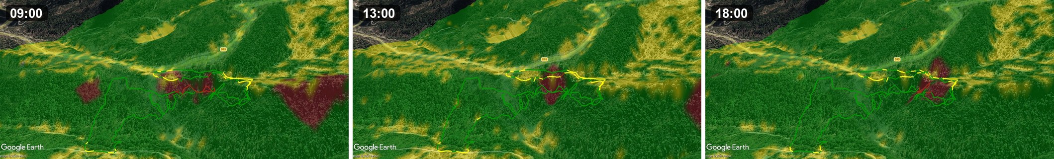
Same track, three times of day — the cast shadow moves across the terrain.
How to use it in Locus Map:
1. Load the generated MBTiles as a map overlay (Settings → Maps → overlay).
2. Import the colored track KML as a regular track (the overlay is a raster, so the track comes separately).
3. Keep the overlay opacity at 100 %. The semi-transparency is already baked into the tiles
if you lower Locus's layer opacity, Locus re-composites the tiles and faint seams appear between them. At 100 % it's seamless.
Outputs: KMZ (Google Earth), MBTiles (Locus / OsmAnd overlay), colored track KML. Input is a GPX + a date/time. Runs on Windows / Linux / macOS, GUI or CLI.
Repo (code, build, docs): https://github.com/nico579/gpxsolar
It's a hobby project — feedback very welcome, especially from people who load custom overlays in Locus.
 I like this idea
Thank you for your work. I think this would be a better place for it:
https://forum.locusmap.eu/index.php?board=43.0
https://forum.locusmap.eu/index.php?board=40.0
https://forum.locusmap.eu/index.php?board=44.0
An admin might be able to tell you which section is the best.
Thank you for your work. I think this would be a better place for it:
https://forum.locusmap.eu/index.php?board=43.0
https://forum.locusmap.eu/index.php?board=40.0
https://forum.locusmap.eu/index.php?board=44.0
An admin might be able to tell you which section is the best.
Thanks, that's helpful — I didn't realize the Tools board was the right home for this. I'll repost it there (board 44).
Appreciate you pointing me to the active forum. you were right, that's the active place for this.
I've posted gpxsolar in the Tools board, and a sibling tool (lidar2map, for LiDAR relief overlays) alongside it:
- gpxsolar: https://forum.locusmap.eu/index.php?topic=9635.0
- lidar2map: https://forum.locusmap.eu/index.php?topic=9636.0
Appreciate the help.
Replies have been locked on this page!