
Better Track Stats (and Laps for Skiing)
I use locus pro most for skiing, especially backcountry skiing, and other mountain sports.
In another post I mentioned how awesome it would be if laps could calculate based on elevation gain/loss instead of distance. For example, I ski down 1000m. Then I go up 1000m. If it were smart enough to say any switch from down to up (or up to down) of more than 75m (or 100m, even better if I could set it myself) is a new lap, then it would accurately count ski runs, both backcountry and at a ski resort. This has already been suggested so I'll move on to the main idea of this post.... more advanced track stats.
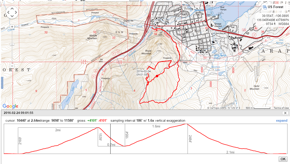
There is an awesome mapping website in the US called caltopo.com. If I draw a route on there or import a gpx file from a recorded track on locus pro, I can see all of this awesome info about the track. Note the elevation profile at the bottom. It automatically identifies / splits up the recorded track into the first major uphill gain of the day, the first ski run, the second skin up the hill and the second ski run. Within each segment it gives stats (distance / elevation) of that segment. Also, if I move the cursor along the profile data, it moves the dot along the recorded track to show where that was. The real cool part is when I click the expand link top right of the profile window.
When you expand the track data you can see all of this (below). Most important for skiing is the top, multi-colored horizontal bar under the line chart (directly underneath the mileage markers). This is color coded for slope angle. Avalanches most often occur in 30-45 degree angle steepness. Green is under 27 degree. Yellow is 27 d - 29d. Orange is 30-32 degree. Red is 35-45d, etc. It's also nice just to see the average steepness and max steepness of what you skied that day. It's also interesting to see the bar graphs at bottom that show % of your day spent at various elevations or steepnesses and the aspect you were on most often. This particular example is a track I actually skied but it would also be cool to see this for a track I'm routing / mapping in preparation for a trip.
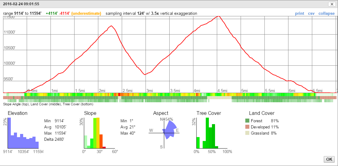
I believe all of the data here isn't taking time into consideration from the gpx file but instead is focused on the distance (for those bottom bar charts). I'm not even sure if gpx files have time stamps on each point or not. Lastly, I'm pretty sure the slope angle data is calculated based on contour lines on the map vs distance, and not based on the elevation vs distance as reported by the gpx file... but I'm not sure. It's also interesting that these line charts automatically select a multiplier for vertical exaggeration by default so the line chart looks right given the zoom level.
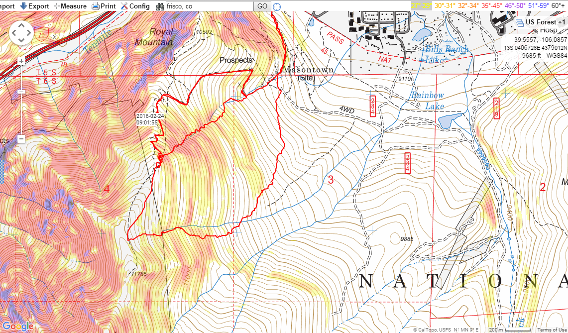
Lastly, this picture below is the caltopo slope angle overlay that can be added to maps. Notice in the far upper-right it shows the color coding scale by slope angle. This is huge for backcountry skiing because of avalanche likelihood at different steepnesses and route planning. Currently I export this layer from caltopo as a KMZ file (using the print link) and then save that in locus pro folders to overlay as mapitems so I can use this in the field. It seems like this could also be handy for hiking & cycling to more easily see where the path gets steeper.
Not sure if there would be a way to incorporate this sort of stuff into locus pro but I think it's all cool information that would be applicable to various sports / outdoor uses but especially for skiing, mountaineering & alpine climbing.
 I like this idea
You are dreaming... we (= the mountain people) all have been dreaming about better support for altitude things in Locus... for many years. The profiles are very rudimentary and quite ugly and not really useful. Unfortunately, the programmer lives in a flat part of a flat country and is more interested in hunting little plastic boxes than in mountains... so don't get your hopes up for decent profiles or laps :).
There is some hope for slope coloring though, the latest beta versions introduce such a feature. It is too buggy to use for now, but at least it seems to be worked on: http://help.locusmap.eu/topic/slope-shading-in-different-colours-30-35-40
FYI, the other post with suggestion to base laps on elevation profile (uphill/flat/downhill) instead of a fixed distance is http://help.locusmap.eu/topic/more-options-for-recorded-tracks
FYI, the other post with suggestion to base laps on elevation profile (uphill/flat/downhill) instead of a fixed distance is http://help.locusmap.eu/topic/more-options-for-recorded-tracks
Replies have been locked on this page!