
Not a good first try at using Locus mapping
I'm afraid it wasn't a good first experience using Locus maps and considering the feedback score on this app in the Playstore I must be doing something terribly wrong.
I've created a route on http://cycle.travel/ and exported it to Locus. As a test I tried out Locus earlier this evening and had the following problems. I've also linked Locus on the Android phone to my Pebble watch using the Locus - addon Pebble app.
- My first problem was that left/right hand turnings at roundabouts were coming up as half lefts/rights as were simple bends in the road.
- Distance to the next turning was grossly over estimated on the watch and didn't match what was on the phone and out of whack with reality on both devices more often than not.
- On one occasion coming up to a roundabout where I was going right it was appearing on both devices as a half left and then when I got on the roundabout it switched to a full right.
- Intermittently I was getting this message OVER_QUERY_LIMIT please see the screenshot
- Also on the screenshot you will see a red line with arrows which was moving about, what is this and how do I get rid of it?
- When I reached my final point I wanted to retrace my steps but couldn't figure out how to reverse the directions for navigation purposes?
I have read the help documents though not all of them but those that seemed relevant and while I wasn't expecting a Google maps experience I wasn't prepared for the disaster I got. So I must be doing something terribly wrong. It would really help if there was a tutorial about how to set up a imported route for navigation which would give clear on screen directions as Locus looks like it's got a bit of a learning curve!!
BTW I've read the definition of route and track on this website and I'm still confused?? This is not helped by the fact that the site I used to create a route called cycle.travel exported the route to a gpx file which was then imported and stored as a track in Locus, very confusing
What am I trying to do?
I want to create a route for cycling that I can follow on my phone or Pebble smartwatch with clear instructions i.e. if there is a roundabout coming up it appears as a roundabout with the correct exit on my phone at least or if there is a turning it displays a clear left or right turn and I'm forewarned of it in advance. I don't think I'm asking too much here, why is this so difficult? I don't want Locus to auto generate a route for me between A and B, I can get Google maps to do this perfectly well.
 The same question
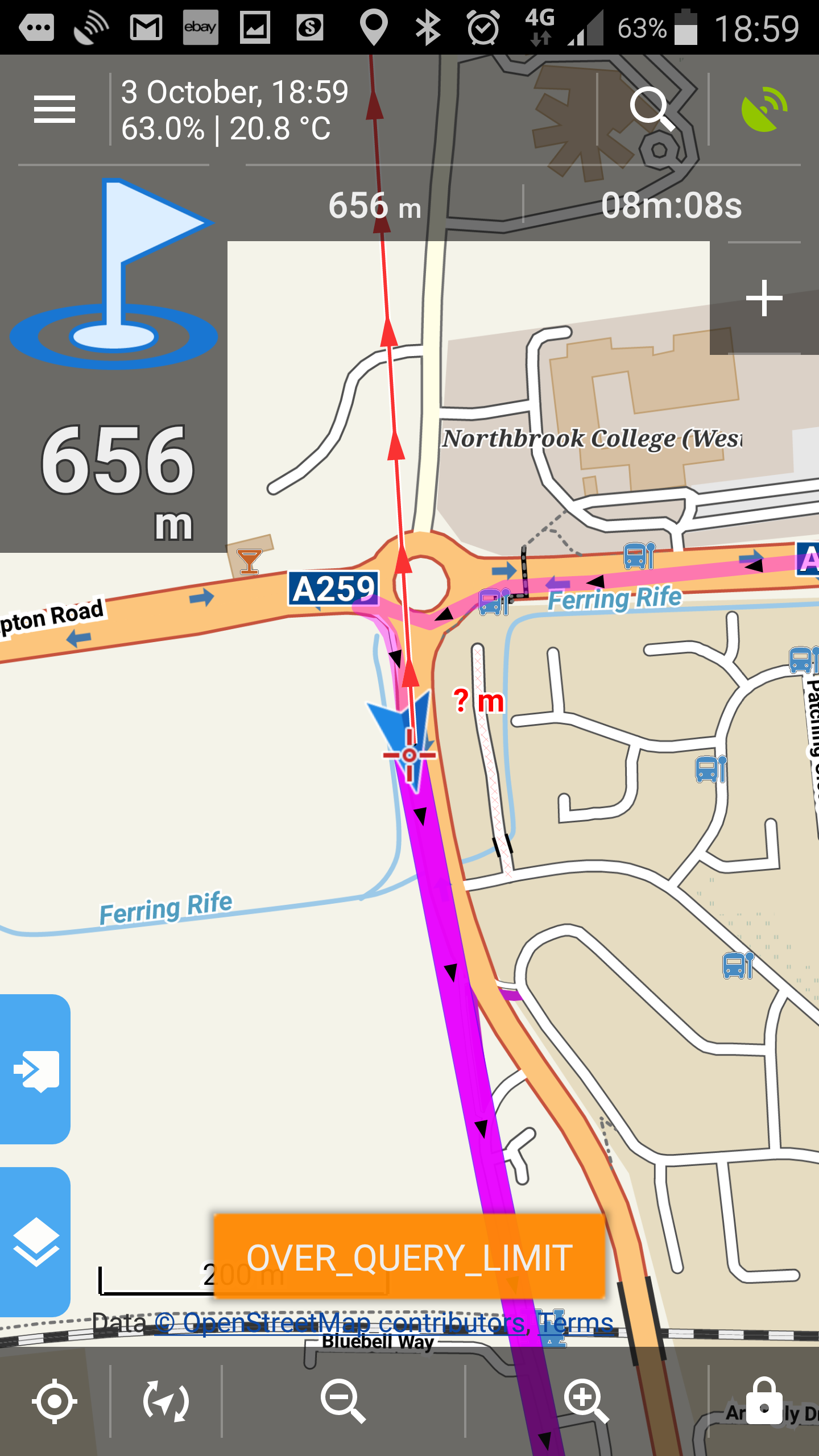
Not being myself an officiial support, just few notes >
Note that Locus does not use any own routing service, but relies on the 3rd party online or offline routing services. If the route is not created by a navigation hint aware routing engine, like online MapQuest of offline Brouter, Locus generate the gints solely on the shape of the route. One of the reasons is, that used MapsForge map format does not allow the road network awareness.
OVER QUERY LIMIT may be the temporary issue with the paid ( by Locus ) MapQuest online routing with limited worlwide quote for the Locus application.
IMHO, Terminology consistence is not a strong part of Locus. Originally route was meant as a rather sparse serie or viapoints, something that was planned on paper map. While track was meant as rather dense serie of logged positions while you were following the route. But later GPX files implemented route and track syntaxes, and various routing engines or planners generated outputs as GPX tracks. All that combined lead sometimes to shifted and confusing used meanings of route and track.
As a cyclist, you may want to be interested in an offline specialized bicycle routing engine BRouter.
https://play.google.com/store/apps/details?id=btools.routingapp
http://brouter.de/brouter/
http://brouter.de/brouter-web/
https://github.com/poutnikl/Brouter-profiles/wiki
Hi Fergus,
- imported routes don't contain any information about intersections, roundabouts - they are just chains of points with coordinates. Locus creates navigation commands just according to the shape of the chain. If you used routing inside Locus ("Navigate to" function) that would generate the route from navigation data, then you would get proper navigation commands including roundabout exits.
- Pebble add-on is not our product so we cannot help here - contact Pebble add-on developer
- the reason I mentioned in the point 1 - Locus creates navigation commands just according to the shape of the route in case it is imported
- MapQuest online router had some issues on Saturday - it way okay on Sunday
- you have "heading line" activated - deactivate it in settings > maps > map objects
- create a copy of the route - open it in the route (track) manager, select "copy" from the bottom right menu, check "change route orientation (reverse)"
- see http://docs.locusmap.eu/doku.php?id=manual:user_guide:functions:navigation:along-route
- you imported your route in Locus Track manager not as a track but as a route - we use "Track manager" just for simplicity - in other languages track and route are the same. In English - Track - a way you went along (left traces on), route - a way you are going to go along.
- create the route directly in Locus using e.g. BRouter (works offline - more info here: http://www.locusmap.eu/locus-map-can-navigate-offline/ and here: http://www.locusmap.eu/the-best-setting-of-locus-bike-navigation/ )
- Google Maps will generate a route between A and B but, as I mentioned in point 1, the exported GPX doesn't contain information about intersections and roundabouts
Locus Map may have a bit of learning curve - it's due to its versatility and multifunctionality - when you learn your own steps you'll like it as others do. Good luck!
I am not sure if Google routing for bicycles is optimal. Many routing services, that are mainly focused on car navigation, do not consider the elevation profile of suggested routes, nor physical conditions of the road/tracks. Both is essential for bicycle trekking.
I am not sure if Google routing for bicycles is optimal. Many routing services, that are mainly focused on car navigation, do not consider the elevation profile of suggested routes, nor physical conditions of the road/tracks. Both is essential for bicycle trekking.
Okay lets break this down...
Okay this makes sense.
So it wont' recognise roundabouts or junctions since as you said it is following the shape of the chain.
But you just said Locus only follows the shape of the chain. So what is interpreting this chain and recognising the roundabouts, junctions etc?
I was actually using it yesterday, Monday. Huh? Why am I using MapQuest thought Brouter was set as my default router??
Turns out it was my course bearing line that was on.
Yes sorry read this later on that evening.
Yes already been through that several times before using Locus but then had the problems I experienced yesterday hence this email.
Will have to go through that second link, thanks. I've also read this...
So Locus takes a gpx file displays it and creates navigational instruction for e.g. a cyclist, driver, walker i.e. turn left at next junction, take 3rd exit at next roundabout etc.
Whereas BRouter just ....well to be honest I'm a little confused what Brouter actually does but I presume it creates the gpx files from what the user draws on the map within the Locus map??
I've created a route within Locus and so far have found this to be the most reliable as regards retaining navigational instruction data. The problem is when I copy and reverse the route I'm back to square one and a lot of the instructional data is lost again?? Why does this happen?
Do I have to map out the route manually going the other way???
--- OFFTOPIC ---
Small note from me ... damn long discussion. Seems to be sooo complicated ... if result of this discussion will be something we may do to simplify this (some change in UI, better description in manual, ...), let us know, we will gladly improve it (or at least think about it)!
--- OFFTOPIC ---
Small note from me ... damn long discussion. Seems to be sooo complicated ... if result of this discussion will be something we may do to simplify this (some change in UI, better description in manual, ...), let us know, we will gladly improve it (or at least think about it)!
As as newbie you should prefer questions ( like "What have I done wrong ? " ) to statements ( like "It does not work." ).
It is more reliable for you, as it has not given you chance to corrupt the thing. Look again back to 4 ways of BRouter usage I mentined. The import of GPX from Brouter-web and the 5th one and all work.
You may find use for the quite good documentation at http://docs.locusmap.eu/doku.php?id=manual:basics. It would be good to study the stuff, not to explain already explained. Sure. no manual is as good as without possibility to be improved..
Reversing is fine for guidance, but not for navigation with the ready to use data for given direction. As instructions are unidirectional.
First I have read the relevant basics as I've already stated. But I as far as I can see Locus is far from a polished app that just works. It's full of options that either trip you up or don't often work as they should.
I believe the theme of my questions in this thread has always been "What am I doing wrong?"
Very offtopic too.. but I can feel the pain of the OP.
There is a need of some eli5's regarding different settings/noobs to turn under activities like sailing, mtb/cycling, driving, guiding, trekking, tracking, skiing etc.. I would easily spend 15 minutes on a youtube video to learn settings in locus before cycling in an unknown area. Mainly because my Locus is set for tracking/routing related to geocaching/hiking/trekking.
A profile choice when opening app would be awesome..
Usercases here:
I was tryin to get Brouter to find a route to a peak, no trails, no paths...<20° climb...just too realize Brouter was a bike engine. No luck, ofcourse. Settled with Graphopper, mostly happy with results. With my Note, I make route in "sketch a track"-app, import to locus...view in Earth. Good to go!
If I'm activating auto-gps off when tracking, no line is shown on map. Have a track-profile with 100m-60sec-100m...use that, and hope it saves battery. But then, back home, its not straight forward to edit track.
Every time I start tracking from widget, I need to check profile before start (because I forget what profile is active).. should be text/symbol in there somewhere.
Sorry for this rant (4 year happy user of Locus)
Hallgeir
I manually created a journey within Locus on my tablet and transferred to my phone and followed it today with the following problems. The first two problems below were covered in a Utopian fashion by the knowledge base but surprisingly the second 2 were not covered at all. Considering I've seen them plenty of times in the last few days maybe they should be added.
I manually created a journey within Locus on my tablet and transferred to my phone and followed it today with the following problems. The first two problems below were covered in a Utopian fashion by the knowledge base but surprisingly the second 2 were not covered at all. Considering I've seen them plenty of times in the last few days maybe they should be added.
Fergus, something in your setup/setting must be wrong. I do your kind of task every now and then, and it never fail me. Just hang in there, you will get help!
Just for clarification, what is your device and android version? 6.0 users has been a victim of the infamous gps-sleep syndrome. Android battery saving kicking in..
Hi Hallgeir,
I've got a Note 4 on Android v6. I've disabled all battery saving features for Locus apps. I don't have a problem with getting and keeping a gps fix so not sure what else could be wrong with my setup.
Hi Hallgeir,
I've got a Note 4 on Android v6. I've disabled all battery saving features for Locus apps. I don't have a problem with getting and keeping a gps fix so not sure what else could be wrong with my setup.
And your setup is online map/offline map, maps stored internal or sd card, bluetooth on/off, any protective case that can interfere with gps/compass?
Basically serve all info you can recall to have done since initial installation. There is also the option to reset the app settings and operation.
As a start i would go for simple solution, not Brouter yet. You need a working setup before going advanced..
Start of with a short route, then get confidence to proceed..
I've turned off wifi and mobile data on my phone and want to draw a bicycle route in Locus but it's not joining the waypoints I'm putting down on the map according to the road shape. I thought this part used Brouter which I've got installed inlcuding the necessary Brouter data files. Really confused as to why this is not working
I've turned off wifi and mobile data on my phone and want to draw a bicycle route in Locus but it's not joining the waypoints I'm putting down on the map according to the road shape. I thought this part used Brouter which I've got installed inlcuding the necessary Brouter data files. Really confused as to why this is not working
What should work for you is this guide about using BRouter assistance at route planning.
Watch especially the short tutorial video ( Page not done by me, but the procedure works ).
What should work for you is this guide about using BRouter assistance at route planning.
Watch especially the short tutorial video ( Page not done by me, but the procedure works ).
This topic is going really wild... too much questions and suggestions from too much people, each addressing a different issue. Okay I'm going to try to tackle as much as possible:
@Fergus: Do I have to map out the route manually going the other way???
- if you are not content with the reverse copy option, yes, you do. The route in the original direction is calculated by the routing engine - if you want Locus to make a reverse copy of it, Locus handles it as a GPX line WITHOUT original navigation commands as they don't have to be valid in the opposite direction - therefore, Locus generates new commands according to the shape of the reverse line. Another option is to use routing engine again to calculate the return route - the route thus doesn't have to be the same as the router takes oneways (and other parameters) in account.
@Fergus:
How do I stop the zoom from changing during navigation?
- Settings > Maps > Advanced features > Speed auto-zoom OFF
Set notification of next direction change - This was set to a very loud beep but over the hour I was using this feature I had only a single beep even though there were plenty of direction changes.
- this feature works only if "guidance" is switched on. If you used guidance along a route and Locus didn't alert you about direction changes then increase number of beeps in settings >guidance > advanced > number of alerts
Over Query Limit - this kept coming up even though on commencing my navigation I made sure I was using Brouter as the source.
- have you set BRouter as your navigation data source in Locus settings > navigation > navigation data source? If yes and this alert keeps coming, try to erase your temporary files in settings > miscellaneous > clear temporary data and restart Locus
Unknown problem consider selecting different Nav source
- should be related to the previous problem, try the same procedure
I want to draw a bicycle route in Locus but it's not joining the waypoints I'm putting down on the map according to the road shape.
- http://www.locusmap.eu/have-you-tried-engine-assisted-route-drawing/
@Halgeir
Profile choice when opening app would be awesome
- we've been having a long internal discussions about this, please be patient, perhaps they'll come into reality some time (my preference too)
Auto-gps off
- this setting is often in "conflict" with your recording profile settings especially the GPS accuracy parameter and time frequency of trackpoint recording - make sure the GPS auto.off values don't limit recording ones
Rec profile sign in widget
- we'll think about it, a good idea
Yes think I will start a new thread for any further queries just to keep it simple.
BUT before I do and this has been annoying the hell out of me. What is the difference between Fast & Short bike?
Why can't this be implemented for Navigation as well?
Yea sorted this one out last night but will watch the video link when I get back after the weekend :)
Thanks for all your responsive help so far :)
What is the difference between Fast & Short bike?
- fast - along roads with smooth surface, as flat as possible - you can ride fast
- short - the distance is short no matter what the surface or elevation profile of the way to the target is
Notification of next direction change - Why can't this be implemented for Navigation as well?
- that's the difference between navigation and guidance - navigation works with voice commands and visual signs of where to turn, guidance with beeps/TTS and guiding line on map
Could I suggest this as a future implementation option please.
When I'm cycling along I really don't want to be staring down at the screen all the time. I want to be admiring the scenery. But I also like to be zoomed in so I can see any potential tricky sequence of turns. I also don't want to be listening to TTS. So ideally I would like to be able to concentrate on what's around me and get a warning beep when I need to pay attention and look at the screen.
Most of routing services offer fast/short atributes for car/bike route calculation. the Locus and Brouter follow this logic. With Brouter, you can assign to these Short/Fast modes whatever BRouter profile you want. So Fast and Short can be considered as a purpose hints, or just random names for slot1 and slot2. I usually set to Short the profile I use if weather is fine and I am fresh, like Trekking-dry or MTB. I use for Fast the "homing" profiles as a kind of a fallback at bad weather or if I am tired, ljke Trekking-wet, or MTB-light, More can be seen at https://github.com/poutnikl/Brouter-profiles/wiki .
Most of routing services offer fast/short atributes for car/bike route calculation. the Locus and Brouter follow this logic. With Brouter, you can assign to these Short/Fast modes whatever BRouter profile you want. So Fast and Short can be considered as a purpose hints, or just random names for slot1 and slot2. I usually set to Short the profile I use if weather is fine and I am fresh, like Trekking-dry or MTB. I use for Fast the "homing" profiles as a kind of a fallback at bad weather or if I am tired, ljke Trekking-wet, or MTB-light, More can be seen at https://github.com/poutnikl/Brouter-profiles/wiki .
Thanks libor, yes I see what you mean. Actually when I am a bit more organised I will delve mkore into BRouter. Let me start a new thread as I have a few questions re route planning. Are you happy for me to post them here or do you want me to post them on Git?
Thanks libor, yes I see what you mean. Actually when I am a bit more organised I will delve mkore into BRouter. Let me start a new thread as I have a few questions re route planning. Are you happy for me to post them here or do you want me to post them on Git?
Replies have been locked on this page!