
This object is in archive!
Navigation route sometimes rendered behind other objects or inconsistently
Solved
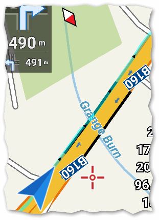
Example below of navigation route apparently rendered behind the road:
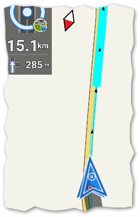
Example below of navigation route rendered partly thick (correct) and partly thin:
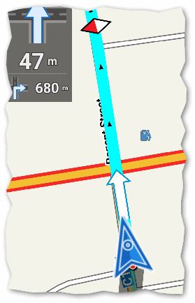
For comparison, example below of properly rendered navigation route which is similar to screen cap in the manual:
Sorry but I don't have a track or way to reproduce this behavior.
 The same problem
Something +/- similar to next observation ? (I hope it helps here)
See picture with navtrack and POI: "Knooppunten" (name = number).
I prefer POI symbols on top above the navtrack ...they are, IF using map rotation !
Something +/- similar to next observation ? (I hope it helps here)
See picture with navtrack and POI: "Knooppunten" (name = number).
I prefer POI symbols on top above the navtrack ...they are, IF using map rotation !
Hello guys,
this issue is in Locus for many years already. Issue is in (probably) incorrect computed part that should be drawn fat and part (behind current location) that should be drawn thin. So line is not hidden, it's just incorrectly drawn.
Hello guys,
this issue is in Locus for many years already. Issue is in (probably) incorrect computed part that should be drawn fat and part (behind current location) that should be drawn thin. So line is not hidden, it's just incorrectly drawn.
Aaaaa ecstasy!! Issue finally fixed ... thanks Andrew for a kick in right time. After many years, I'll finally see my most wanted fat line before navigation cursor, all the time :).
Aaaaa ecstasy!! Issue finally fixed ... thanks Andrew for a kick in right time. After many years, I'll finally see my most wanted fat line before navigation cursor, all the time :).
Perfect Menion! For me it has occurred very rarely. I don't know how to reproduce or verify any fix. It seemed to be in testing when I stopped/ restarted navigation part way along the track. If I ever see again I'll try to capture & report.
Perfect Menion! For me it has occurred very rarely. I don't know how to reproduce or verify any fix. It seemed to be in testing when I stopped/ restarted navigation part way along the track. If I ever see again I'll try to capture & report.
Not sure entirely solved. Below are screen caps from 3.20.1.12 with good (thick) & bad (thin) navigation lines. Problem still with track that does U-turn and returns to original start position?
Not sure entirely solved. Below are screen caps from 3.20.1.12 with good (thick) & bad (thin) navigation lines. Problem still with track that does U-turn and returns to original start position?
Menion, I don't think this bug is fixed. Attached is screen capture at end of navigation track. Clearly visible is thin navigation line then further on the proper thick line. The screen shows GPS location. It happens rarely, but in last few days each day. Track created by external BRouter method.
Menion, I don't think this bug is fixed. Attached is screen capture at end of navigation track. Clearly visible is thin navigation line then further on the proper thick line. The screen shows GPS location. It happens rarely, but in last few days each day. Track created by external BRouter method.
Good day Andrew,
thanks for a bug report. I saw similar problem a day before on wife's phone and can't believe it. I do not know exactly this happen and even with your track, I was not able to simulate it.
Anyway I'll be watching it, thanks for notification!
Good day Andrew,
thanks for a bug report. I saw similar problem a day before on wife's phone and can't believe it. I do not know exactly this happen and even with your track, I was not able to simulate it.
Anyway I'll be watching it, thanks for notification!
Did you have multiple tracks on the same route when you saw the problem? I had multiple tracks, different BRouter profiles of course. No problems other days but I hid the unused ones. Made no difference. I simulated too just before real completion and seemed same issue but maybe just my inexperience. At least you also see the issue. Thanks.
Did you have multiple tracks on the same route when you saw the problem? I had multiple tracks, different BRouter profiles of course. No problems other days but I hid the unused ones. Made no difference. I simulated too just before real completion and seemed same issue but maybe just my inexperience. At least you also see the issue. Thanks.
Menion, I had the same repaint issue today. A few comments and recollection from when topic originally written
1 this problem fixed if route recalculated but I never wish to recalculate because precise existing route is often varied
2 no problem if use Navigate To function instead of navigation using existing track
One question: (re)calculation of existing BRouter track appears to ignore any nogo areas. Consideration of visible nogo areas (point) when creating any track using Locus track creator or editor may be good new topic.
The day after my previous comment I observed same issue. The proper thick navigation line was only drawn 1km ahead of GPS position!
But in following 5 days of navigation using same track creation and navigation there has not been a single problem. I've tried various tricks to provoke the problem but all OK.
Good day Andrew,
heh funny ... you personally may see, that simulate this issue is not so easy. Thank you for additional information. I'll be watching it carefully as well, so hope that soon or later we will find the key on this puzzle. Thanks for now!
Good day Andrew,
heh funny ... you personally may see, that simulate this issue is not so easy. Thank you for additional information. I'll be watching it carefully as well, so hope that soon or later we will find the key on this puzzle. Thanks for now!
Being a cycle tour I will only be riding the track once, so not possible to test either sorry. At least it is not always a problem but somewhat strange no other reports?
Being a cycle tour I will only be riding the track once, so not possible to test either sorry. At least it is not always a problem but somewhat strange no other reports?
Hi Menion. Have now finished cycle tour - 3000km. As promised, attached are 3 screenshots from 3 weeks ago when last discussed. As you can see whole sections of map not rendered until Locus restarted, or even on one occasion phone restarted. There have been no more problems since.
Hi Menion. Have now finished cycle tour - 3000km. As promised, attached are 3 screenshots from 3 weeks ago when last discussed. As you can see whole sections of map not rendered until Locus restarted, or even on one occasion phone restarted. There have been no more problems since.
Good day Andrew,
3000 km, quite crazy! Hope you had a nice time not disturbed by rare Locus problems, or bad weather :).
Thanks for a screenshots. I'm riding on bike or moto last days quite a lot, always using navigation and never saw this problem. You write that for next three weeks, no more problems again. Hmm I think that issue may still be there, but because of unpredictable and really rare occurrences, we may leave it for now, thank you!
Replies have been locked on this page!