
Distance to each top of hill
Gathering feedback
Hello. I'm bicyclist and I use Locus a lot of time. One thing i miss which GARMIN have..
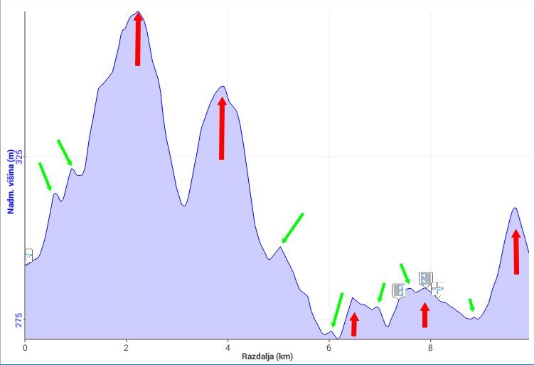
For me can be very useful if navigation can show you how much distance you have to next top of hill (red arrows) and in some way ignore little tops on the way (green arrows) - see picture example...
Thanks
Regards
Kristijan
Files:
locus.jpg
 I like this idea
Great idea.
Then we should be able to define the prominence ourselves. (How far down we must go to get to a higher point).
Great idea.
Then we should be able to define the prominence ourselves. (How far down we must go to get to a higher point).
Please check my comment under that idea:
http://help.locusmap.eu/topic/distance-to-a-highestlowest-point-of-a-previously-recorded-track-or-a-part-of-it
For me this solution is more then useful. :)
Please check my comment under that idea:
http://help.locusmap.eu/topic/distance-to-a-highestlowest-point-of-a-previously-recorded-track-or-a-part-of-it
For me this solution is more then useful. :)
I've recently asked for similar, just more generic and manual feature, allowing user to mark via points on existing track as subsequent targets, with usual navigation stats (distance to, ETA, target reached) offered for them. In any case, dividing a long route to more fractional segments during navigation would be convenient.
What I'm also missing is absence of ascent elevation remaining to final target (or nearest subsequent target which would be next hill in this case)
Replies have been locked on this page!