
Locus 330 altitude management
Hi,
Today, I made a hike (about 9 km). I recorded the GPX file using Locus Pro 330 installed on my Samsung Galaxy S8+ (Oreo) smartphone. My goal was to record of the most precise possible altitude. My altitude manager settings are:
-Parameters: No offset, SRTM: replace GPS values, use the pressure sensor, light filter
-Pressure: Automatic
I thought that this way, Locus will first use the altitude value extracted from the srtm file and from that point will use the pressure sensor to record some real time altitude values. Also, I read that locus will check each two hours the right value of the altitude from the srtm file and perform some correction in needed in order to avoid the problems related to the weather (and the related ambiant pressure) change during the day. Am I right ?
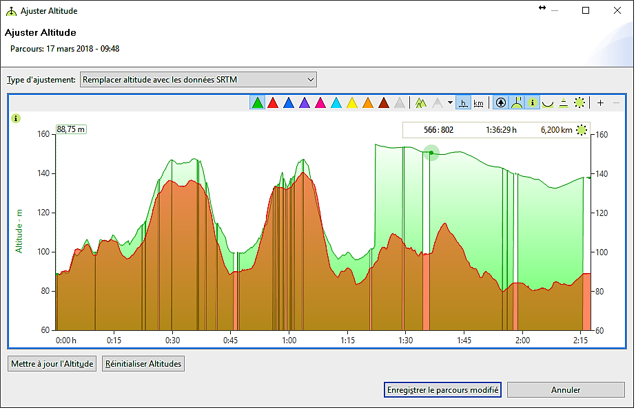
Well I recorded my hike and exported the gpx corresponding file. I opened it using one of my favorite softwares, i.e. MyTourbook in order to analyze the altitude data. I noticed 2 issues.
1. Locus pro generated a relatively huge jump in the altitude value after 1h20 of walk. This is shown by the green curve. The brown curve corresponds to the strm values.
2. One can also clearly see that the altitude value is really exact at the starting point and drifts too much with the time. Locus Pro reads correctly the first value but what happens after that ?
I have attached a picture that shows this effect
Best regards
sl91
 The same problem
By the way, I have also recorded the same hike using my Garmin 935 watch. It has also a pressure sensor. The recorded altitude is attached to this comment.
Regards
sl91
By the way, I have also recorded the same hike using my Garmin 935 watch. It has also a pressure sensor. The recorded altitude is attached to this comment.
Regards
sl91
Hello,
your setup if perfectly valid and is identical to what I use for my own recordings. Jump in elevation is really weird.
Pressure re-calibration is made currently once per hour, but change in made over 15 minutes, so no such jump should be visible.
Few ideas that comes over my mind:
Menion
Hello,
your setup if perfectly valid and is identical to what I use for my own recordings. Jump in elevation is really weird.
Pressure re-calibration is made currently once per hour, but change in made over 15 minutes, so no such jump should be visible.
Few ideas that comes over my mind:
Menion
Good morning Menion,
Thank you for the answer. I will try with another smaller hike that I do very often. I will do a first record today if the snow (and the cold wind) decreases. For this first record, I will do it using the same setup of Locus than yesterday. I only use the SRTM files (.hgt) dowloaded together with the Lomaps as proposed by the Lomaps download process. I have 988 files in the srtm folder corresponding to several european, ,african and asian countries. But some of these files can be much older than the corresponding Lomap, when I buy a newer version.
Best regards
sl91
Replies have been locked on this page!