
This object is in archive!
How to interpret elevation gain in route summary
Answered
Using LocusMap Pro 3.39.4 on Android Pie
When designing a route. I'd like to estimate the elevation gain and slopes. Mostly to determine if it is worth to bring hiking sticks.
In the attached screenshots, LocusMap_RouteStatistics.png shows:
- Elevation loss: -151m
- Elevation gain: 148 m
Intuitively I deduce that the absolute elevation gain is: 148 - (-151) = 148 + 151 = 299 m
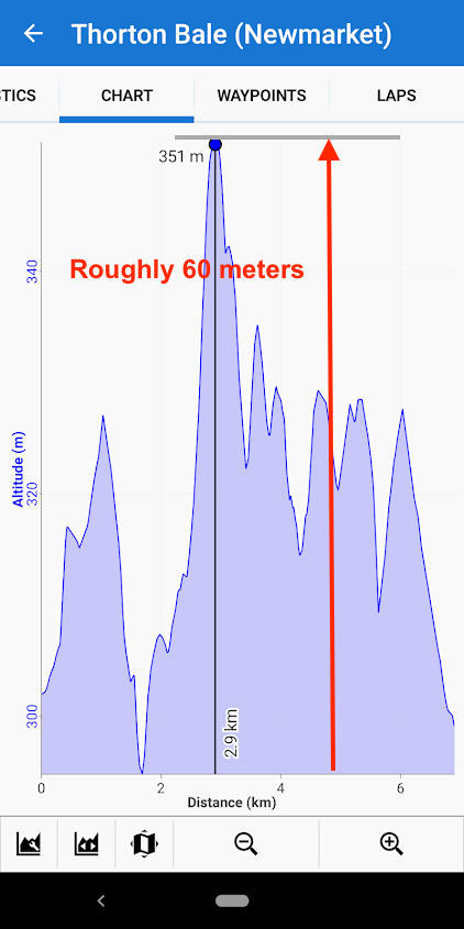
However, the screenshot LocusMap_RouteChart.png shows that the max elevation - mini elevation is roughly 60m (351m - 290m)
 The same question
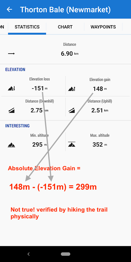
The statistics of a recording also makes no sense about elevation gain:
I just walked that trail today. There is absolutely no way there could be 242m in elevation gain. And even less true for elevation loss. However the min/max altitude seems plausible.
What is Locus' definition of an elevation gain? Because if this is the difference of max - min altitude of the entire route, then there is a bug in the app (Locus Map pro 3.39.4, Sep 2019) in the way it calculate elevation gain/loss.
Hi Tristan,
elevation gain is not subtraction of the lowest elevation from the highest one. It is a total sum of ALL meters walked upwards. Elevation loss is the opposite. See https://en.wikipedia.org/wiki/Cumulative_elevation_gain.
best regards
Michal, Locus team
Hi Tristan,
elevation gain is not subtraction of the lowest elevation from the highest one. It is a total sum of ALL meters walked upwards. Elevation loss is the opposite. See https://en.wikipedia.org/wiki/Cumulative_elevation_gain.
best regards
Michal, Locus team
Thanks for the Wikipedia link. Now that explains everything. It turns out this is just the confusion on the definition of "elevation gain".
I was used to the AllTrails app where elevation gain = max altitude - min altitude. The same info could be obtained from Locus route statistic altitude values.
Thanks for the Wikipedia link. Now that explains everything. It turns out this is just the confusion on the definition of "elevation gain".
I was used to the AllTrails app where elevation gain = max altitude - min altitude. The same info could be obtained from Locus route statistic altitude values.
Replies have been locked on this page!