
It would be very handy to have an option to display grid as an overlay for my online/offline maps.
I work with many different satellite maps however I need a grid like on classic printed map but with better resolution like for example 50m so it would be great to have this feature where you can select color and grid settings.
Here is an example how it worked in PC application
http://gpsmaniak.com/2010/porady-kalibracja-ozi-kontrola.htm
just relate to images
 I like this idea
since my topic was merged I would like to add there is a need for grid like on classic printed map but with better resolution like for
example 50m so it would be great to have this feature where you can select color
and grid settings (because sometimes you work on squares like 25m other times 50m etc; color is important as hipso maps are so colorful that typical color just blends in).
I like this, too.
I like this, too.
This would be extremely helpful for boating and navigating ships, especially since there is usually just a contourless blue surface visible on the map when you are on the water.
Visible coordinate lines/grids may provide the only reference when on water.
This would be extremely helpful for boating and navigating ships, especially since there is usually just a contourless blue surface visible on the map when you are on the water.
Visible coordinate lines/grids may provide the only reference when on water.
Also very useful for geocaching when checking caches for graticule challenges
Also very useful for geocaching when checking caches for graticule challenges
Je souhaiterai pouvoir afficher une grille UTM sur la carte encours d'utilisation
Je souhaiterai pouvoir afficher une grille UTM sur la carte encours d'utilisation
That would be great.
- Display of UTM/MGRS grid
- Display of custom grid that can be exported/imported via some file format. For ex. putting it over 1x1km square and dividing into 100x100m smaller ones with cols/rows names like A, B, C... 1,2,3...
That would be great.
- Display of UTM/MGRS grid
- Display of custom grid that can be exported/imported via some file format. For ex. putting it over 1x1km square and dividing into 100x100m smaller ones with cols/rows names like A, B, C... 1,2,3...
How about Maidenhead Grid Squares? This would be very excellent for Ham Radio
How about Maidenhead Grid Squares? This would be very excellent for Ham Radio
We really need a grid that divides the area, the map into squares, when the size of the map approaches, the squares decrease ... Thank you!
We really need a grid that divides the area, the map into squares, when the size of the map approaches, the squares decrease ... Thank you!
This ability would best be implemented in a general sense and then adapt to specific purpose. I like Maidenhead for radio work, but also would be great to break it down into USGS Quads. Possibly others could do similar things.
This ability would best be implemented in a general sense and then adapt to specific purpose. I like Maidenhead for radio work, but also would be great to break it down into USGS Quads. Possibly others could do similar things.
i like this too. regards
i like this too. regards
i need this too
i need this too
indeed this function would be very useful.
indeed this function would be very useful.
I like this too Either way, I want the map to display a coordinate grid.
I like this too Either way, I want the map to display a coordinate grid.
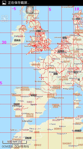
I would like a lot if there would be an option to display a grid on the map based on the distance shown on the scale bar. Example: if on my zoom level my scale bar shows 3 km, then if I have this "grid setting" on I would see a 3 km X 3 km grid over the map. If I click on the scale bar to expand it, the grid size would also be expanded.
This feature would help me a lot with quickly estimating distances while I navigate on the map. I've attached a screenshot as an example (I just randomly drew some lines on the map. Distances are not accurate at all :))
I noticed there's a grid overlay on Locus Map 4 version
I noticed there's a grid overlay on Locus Map 4 version
Replies have been locked on this page!