
This is a similar request as https://help.locusmap.eu/topic/export-of-points-separate-checkboxes-for-attachments-und-formated-description but here regarding tracks.
I'm using Locus for recording tracks to be used for mapping ways and objects for OpenStreetMap. Therefor my tracks generally consist of additional text-only waypoints and waypoints with images.
These addional waypoints can be displayed in OSM-Editors like JOSM and in the case of images also clickable (the image opens after I click onto its icon in JOSM).
These worked until yesterday where I played around within Locus' recording profile within the option "Automatic export" = "GPX".
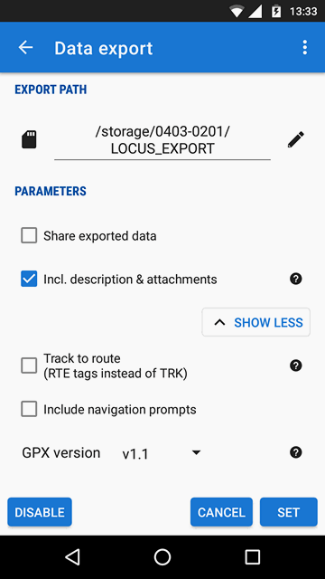
Since then Images are NOT being exported anymore if "Incl. descriptions & attachments" is UNCHECKED. If I check this option, then images are exported - but also some (for me) unnecessary HTML-formated descriptions are exported. And these descritions look very annoying in OSM-Editors and are covering important OSM objects below them (I attached 2 screenshots of OSM-Editors JOSM and iD, and also how it looked before)
I've no idea why this behaviour changed yesterday, cause Locus didn't get updated yesterday. I think by playing around within "Automatic export" settings I triggered some feature which has been introduced during the last months' - where I didn't change anything within the record settings.
So my wish: Please seperate the options to export images and to export HTML-formated descriptions.
 I like this idea
hmmm.... I too noticed creating a 'clean' gpx file inclusive attachment is not fast done nor easy.
Experimental tests: See Point 3.
https://forum.locusmap.eu/index.php?topic=6742.msg57402#msg57402
Notice the CLEAN gpx file.
- Without disturbing auto attached "desc" text and the unnecessary "ext"
hmmm.... I too noticed creating a 'clean' gpx file inclusive attachment is not fast done nor easy.
Experimental tests: See Point 3.
https://forum.locusmap.eu/index.php?topic=6742.msg57402#msg57402
Notice the CLEAN gpx file.
- Without disturbing auto attached "desc" text and the unnecessary "ext"
There's a similar request regarding the GPX-export of tracks to include images but no descriptions:
https://help.locusmap.eu/topic/24761-export-of-tracks-separate-inclusion-of-images-and-descriptions
There's a similar request regarding the GPX-export of tracks to include images but no descriptions:
https://help.locusmap.eu/topic/24761-export-of-tracks-separate-inclusion-of-images-and-descriptions
@Sonny, thank you for sharing. Sadly, your workaround is not really working fine for me, because it requires to put everything (name, instructions2self what to change, required detail infos like length & width & opening hours,...) into the name field which makes that field too huge to be well usable in Locus: name field can't be switched to multi line display, does not scroll nicely in several scenarios, etc.
I found as a halfway viable workaround: I take the picture with normal camera app (file name is the time stamp) so the file is not somewhere deep in Locus' folder structure but sits next to all other photos I take, thus is easy to locate and can be copied in one go (2 advantages over POI attachements). In Locus side panel, I tap quick new point (definition: POI category/folder _OSM, icon "camera" within group Garmin, name "Foto @ {t}" so the POI name contains the timestamp), then edit that point and use the description field to note what I need for the edit in JOSM. So the name stays short (advantage over Sonnys workaround). Biggest downside is I can forget to create one of the two, and while editing in JOSM, I must manually find the photo for a GPX waypoint visible in JOSM.
This issue together with other reasons made me work more with Vespucci and I do edit now much more in situ than before with OsmAnd & mapsMe/OrganicMaps because much more edits are viable. I really like that way of editing because I never think "damn, I forgot to note/memorize this and that, now I can't complete the edit" 😉. But that way has clear limitations, e.g. you need to have social acceptance by your group that you make again a short stop in movement & talks (most changes take longer to map than to just note down), some kinds of edits are very comfortable in Vespucci (e.g. complex opening hours or turning an object) but some cumbersome (especially due to small display and low precision input), looking up definitions in OSM wiki is not really enjoyable (insufficient display size to display it side-by-side to OSM editor and takes reading time during your activity), you need to fetch the OSM data in advance of whole region where you may potentially want to edit – which is huge for a full tour with not-yet-fully-fixed route – respectively you need sufficient mobile coverage in situ AND be willing to pay the considerable fee for D mobile networks data roaming in Switzerland.
@Locus team: I still would like this issue to be solved. Why? Because it seems like quite low one-time effort for you, but reduce efforts (easier & faster) for a huge number of OSM edits – which are relevant for you, because good OSM data is a fundamental requirement for your business. Even though Vespucci now covers a considerable share of my OSM edits, I also do a considerable share of my OSM edits in JOSM and for them, this issue is a certain hurdle that could be lowered.
Replies have been locked on this page!