
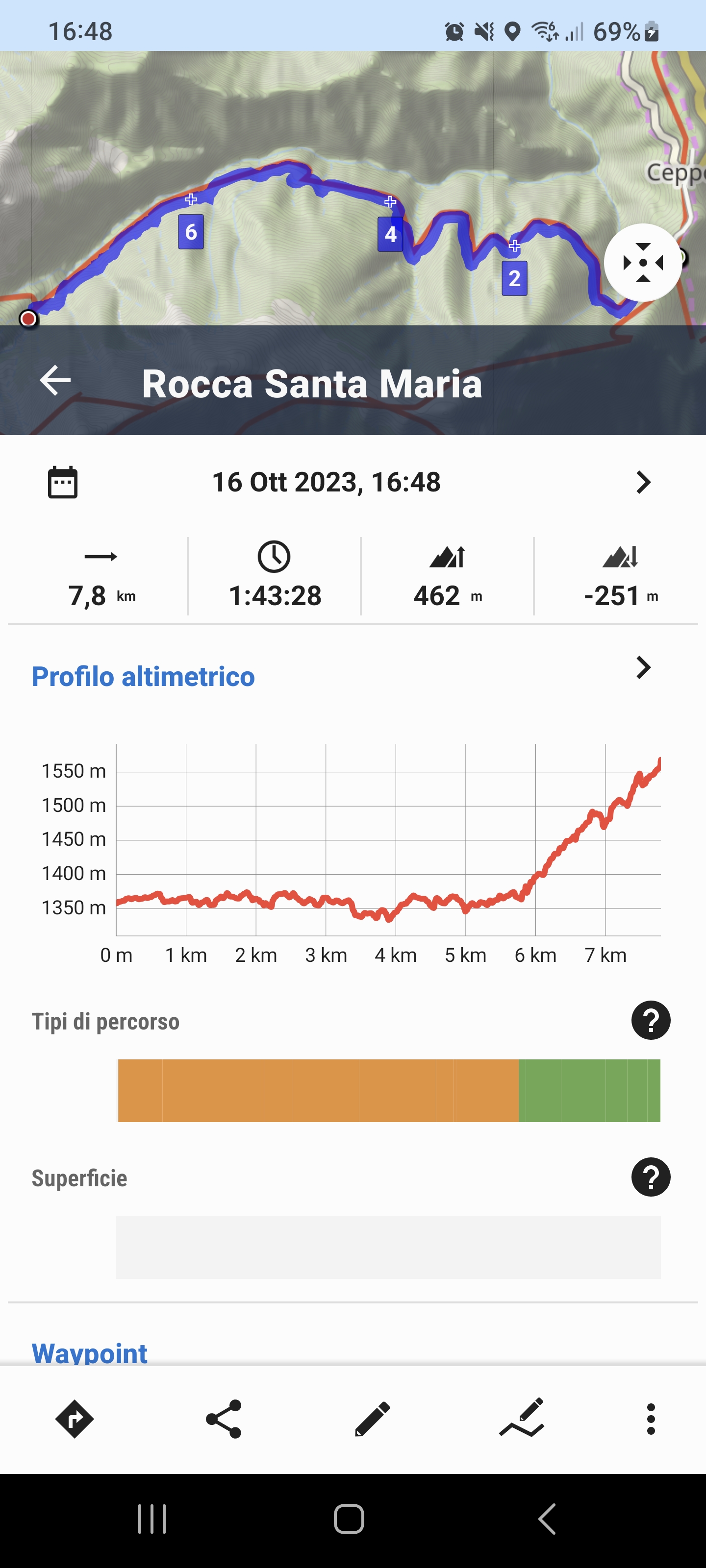
Incorrect elevation for the route.
Hello everyone, I've encountered this issue with a route I'm very familiar with in my region. It's a tourist trail suitable for anyone and can be traversed in any season. The one-way elevation gain is approximately 220 meters over a route that's almost 8km long. Essentially, it's a walk in the park.
When creating and planning the route on LocusMap, the elevation gain is completely incorrect, showing around 476 meters of elevation gain. Thinking it might be due to the old version, I updated to version 4.19, but nothing changed. I'm not sure if the issue is with the map on which the route is planned or with the routing engine, but it's a problem that needs to be resolved. This is because it creates false data, distorting the actual elevation gain. I also tried using the altitude corrections available in the application, but it didn't make a difference.
Attached are the route track and the screenshot of the displayed elevation gain.
 The same problem
The elevation gain that Locus is showing is the cumulative elevation gain. Your track has a lot of ups and downs, and the elevation gain is the sum of all the "ups", that's why it is more than double of what you are expecting. If in reality the trail is constantly ascending, the problem is either inaccuracies in the elevation model or in the path on the map, or both.
The elevation gain that Locus is showing is the cumulative elevation gain. Your track has a lot of ups and downs, and the elevation gain is the sum of all the "ups", that's why it is more than double of what you are expecting. If in reality the trail is constantly ascending, the problem is either inaccuracies in the elevation model or in the path on the map, or both.
Satelitarna mapa nie działa
Satelitarna mapa nie działa
Ciao Ludovico,
oltre ad usare i dati Lidar di Sonny fai attenzione se sul tuo percorso ci sono ponti/cavalcavia/tunnel, spesso falsano la proiezione del dislivello in quanto l'altitudine viene rilevata sul terreno e non sul ponte o sul tunnel, quindi aumenta il dislivello perchè conteggia ad esempio la discesa e risalita ad esempio fino al livelli del fiume che stai superando sul ponte o la salita e la discesa del monte che invece attraversi con una galleria.
Hi Ludovico,
in addition to using Sonny's Lidar data, be careful if there are bridges/overpasses/tunnels on your route, they often distort the projection of the difference in altitude as the altitude is detected on the ground and not on the bridge or tunnel, therefore the difference in altitude increases because for example, count the descent and ascent up to the level of the river you are crossing on the bridge or the ascent and descent of the mountain which you instead cross through a tunnel.
Replies have been locked on this page!