
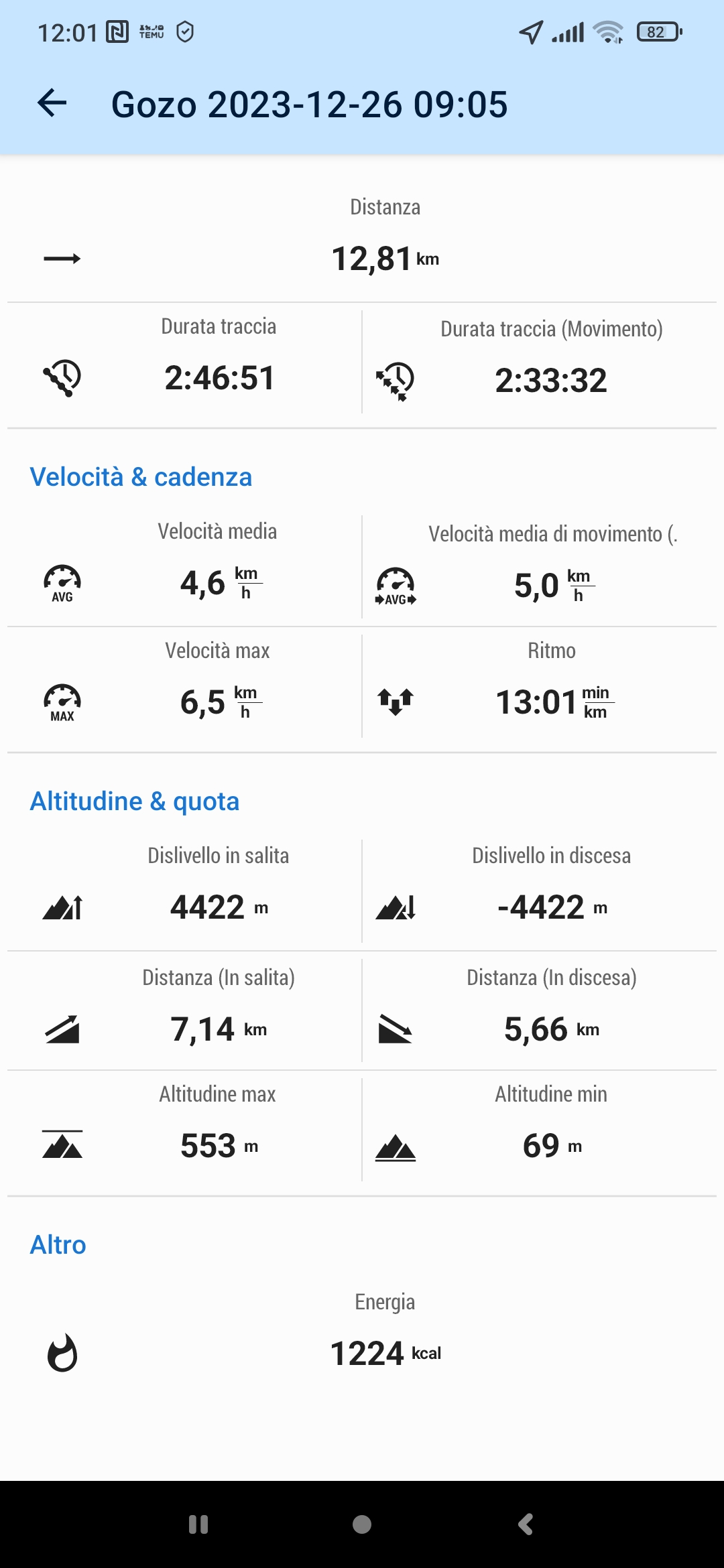
It is impossible to do more than 4000 m altitude in 2.46 hours with 12.8 km distance. See attached screenshot.
This object is in archive!
Wrong altitude in the recording
Solved
It is impossible to do more than 4000 meters with 12,8 km in 2.46 hours. What 'wrong? See attached screenshot
Files:
Screenshot_2023...
 The same problem
How does the graph look like? Must have tons of"virtual" ups and downs, right?
How does the graph look like? Must have tons of"virtual" ups and downs, right?
There are these breakdowns of elevation visible down to 100m. I would look at the NMEA data in /data/nmea folder of Locus.
I cannot imagine Locus is hallucinating here, but rather processes what the device sensor delivers via Android.
In any case the NMEA data is needed to understand first of all. You have to activate this logging in the settings (just search for nmea)
In addition, here is Michal's advise from a similar case:
Please get Locus Map permission for all-time access to the location and exclude Locus from all means of battery optimization so that the app can run in the background, see http://docs.locusmap.eu/doku.php?id=manual:faq:gps_lost_fix_android6. Also, try switching on or off Google Services assisted location in Locus settings - GPS&sensors.
Hi,
When I install an app, I am not supposed to look at Wikipedia nor to know some tricks to let the app work correctly. The app should work, that's all. If not, I simply look for a different app.
I have uninstalled, then installed again th app on my Android smartphone.
I have done a short test this morning leaving the settings as they are. And it works! I hope it will work well again longtime.
Regards
Not sorry to contradict, Aldo.
Reality is, that there is a potentially complex interference between the different layers of the hardware and software architecture of the beast that you hold in your hands so smoothly. In most cases you are right in the assumption and wish to be ignorant of above and just enjoy an app. When it comes to geo apps, people may experience a hard fall. When you look around in the web in the right forums you'll even find cases where Google Maps looses GPS location. Especially with device vendors that employ a rude "battery saving" policy in their Android flavor (in the past Huawei was most infamous - they even killed apps that when they ran as a service and were exempt from any "savings".
But you are happy to see it just work now and can forget about digging for details in log files. Enjoy :-)
Your device has a problem. There are two ways out: 1) dig deeper in root cause analysis (not your preferred way I understood from your earlier post) 2) download Sonny's elevation data 1", mostly LIDAR for Europe, then instruct the Locus Altitude Manager to use those data instead of GPS.
That will fix your vertical dropouts. If there should be horizontal GPS gaps, option 1 is the only way.
I also use the lidar data from Sonny. If the weather is stable, you can also use a barometer. Some phones have this built in. You can set it up in the Locus altitude manager.
In some cases this can even be an advantage.
I also use the lidar data from Sonny. If the weather is stable, you can also use a barometer. Some phones have this built in. You can set it up in the Locus altitude manager.
In some cases this can even be an advantage.
Hello,
yes, this could be the solution for already recorded routes. For the new recordings you can achieve the same result if you use SRTM data instead of recorded ones.
Here are some recommendations for the altitude fix:
Open Locus settings > GPS&sensors:
More here: https://docs.locusmap.app/doku.php?id=manual:faq:wrong_gps_data#custom_altitude_threshold
Zdenek, Locus team
Hi 0709,
Ok, let's assume that vertical accuracy is not very good. However, what is "good enough"?
If I'am hiking for 15 km where the altitude should be, let's say, 1000 meters, and at the end of the day the app shows 1010 meters, that's fine, really it doesn't matter. If it shows 4987 meters... would you agree that the GPS experience is below zero? 🤣
In 2023 I have recorded 25 hikes, about 370 km and 25.000 meters positive in total. If the altitude sum was 25.103 instead, I would even sleep at night like a baby.
On the contrary, if it was three times, ok, I would look for another app. Or no app at all.
Bad weather today and for the weekend. I will test again next week and will let you know the issues.
Forgive me for my bad English
Michael,
I thank anyone have posted some suggestions on this matter. I'm keeping trying and I will do some more tests as soon as I can. However, I'm quite sure that I have found a good compromise (see one of my previous post) adjusting the height difference "after" recording it, with the option that I didn't notice before.
Again, thank you for your help. I will let you know.
Hi everybody.
Sunny morning today, I did my usual training walk. In attachment, see the screenshot of my tracking. Originally the height difference was more than 2000 meters during 10 km walking, but I used the option "adjust altitude" and finally the result was reasonable (see my previous posts). I don't care if it is 100% accurate, it seems good enough.
This solution is suitable for me.
I hope this will help anyone having the same problem.
Thanks a lot for you support.
Il 6 gen 2024 10:05, Locus Map <locus.map@asamm.com> ha scritto:
Replies have been locked on this page!