
Error in elevation calculation in tracks
Hi,
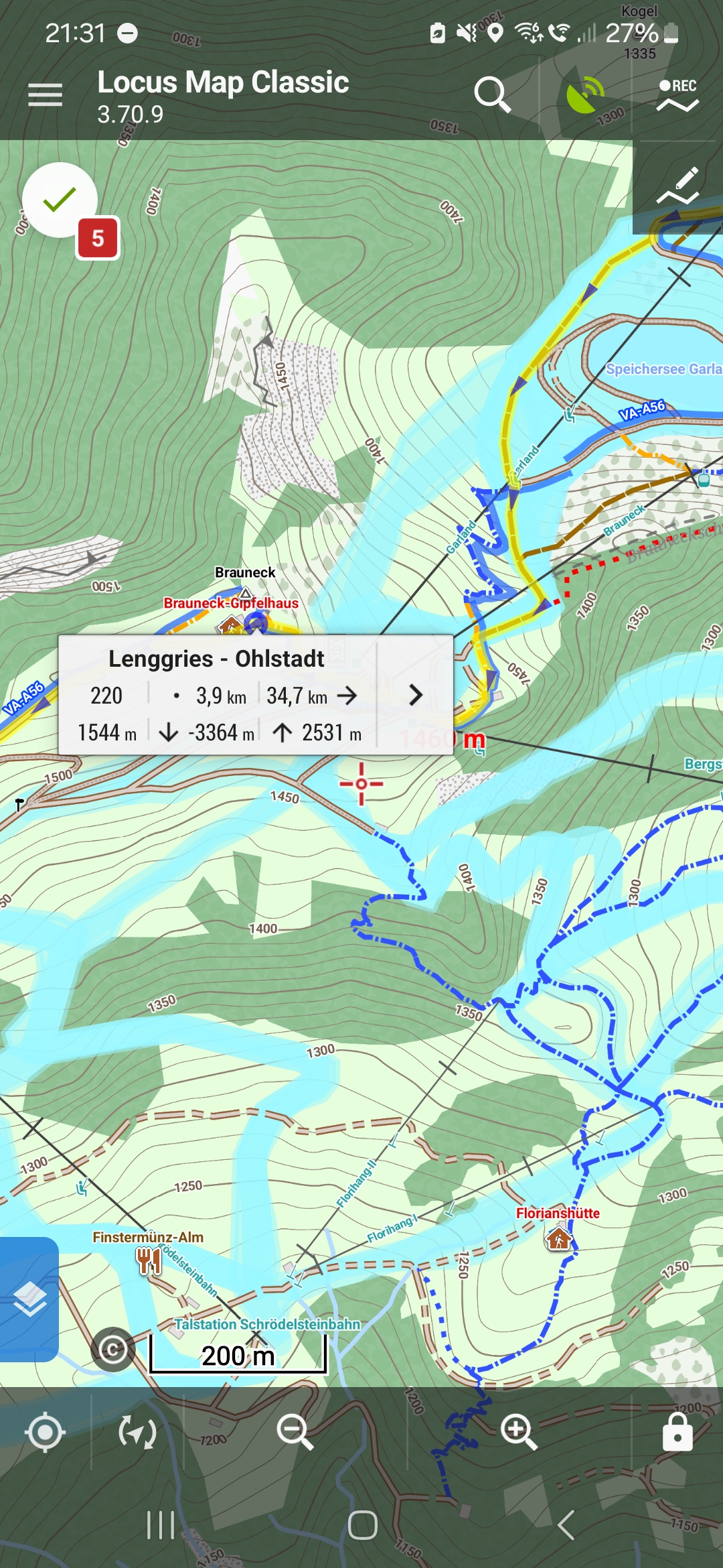
I created a track in the app. Then clicked on the track to select a specific location, basically my first supply station. The small window which appears shows distance from start (3.9 km), D+ (2531m) and D- (-3364m)) to finish (screenshot Screenshot_20240521_213116_Locus Map Classic.jpg).
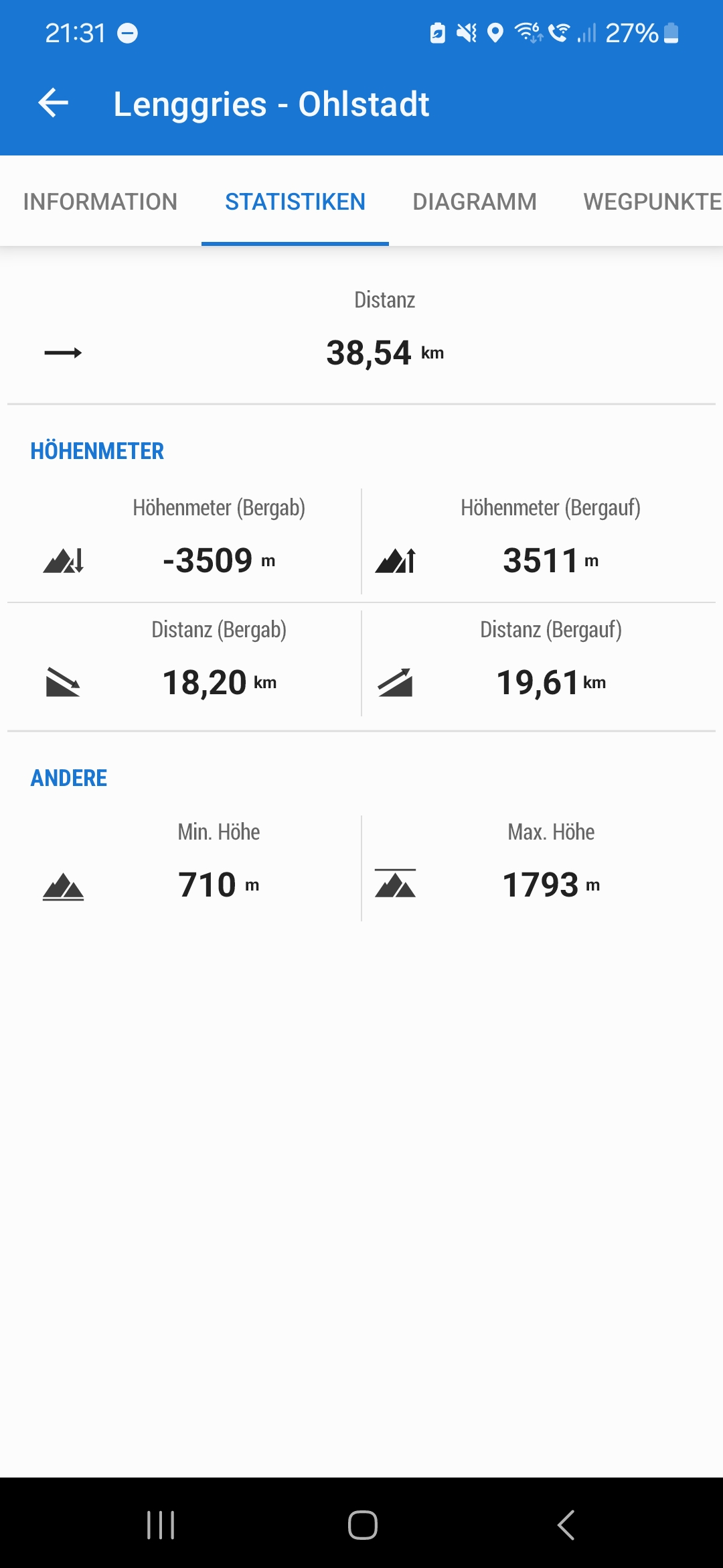
From the overall statistics of the track you see total D+ (3511) and D- (3509) (screenshot Screenshot_20240521_213124_Locus Map Classic.jpg).
I'm subtracting the value of the small window from the total value to get D+ (3511m - 2531m = 980m) and D- (3511m - 3364m = 145m) for the specific location.
When creating the track, the route to this specific location is showing just 844m D+ and -10m D- (screenshot Screenshot_20240521_213150_Locus Map Classic.jpg).
I've check with another track, same issue. I've tested Graphhopper, BRouter and different hiking profiles. All the same.
My environment: Samsung S23+, Android 14, Locus Map Classic 3.70.9, maps: openandromaps (Alps East).
Can you please check.
Thank you and best, Thomas
 The same question
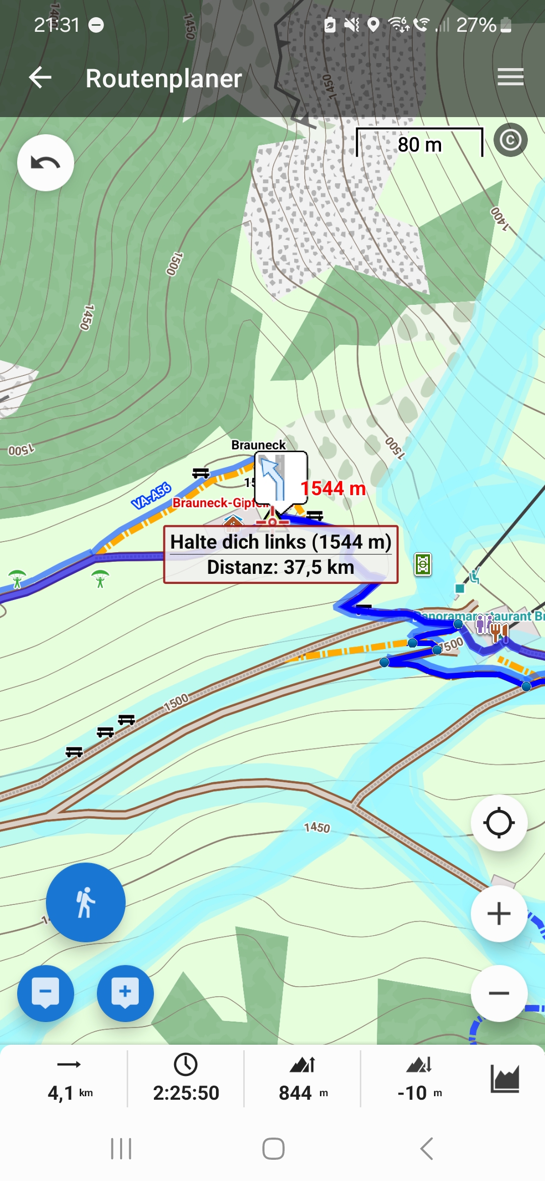
Hi Thomas,
Locus Map displays positive and negative cumulative elevation gain on the track point detail, not just a difference of elevations. Therefore it is not possible to simply subtract part of the track from the whole track. The cumulative elevation gain of a track part from A to B is not the same as the cumulative elevation gain from B to A. More about elevation gain calculation >>
Hi Michal,
CEA is clear for me. But I don't get you answer regarding the track point detail. From my expectation, the track point detail should show me the relative data either from the start or to the finish: distance, D+, D-. You are saying it isn't? But then, where else would I get the data from?
Best, Thomas
The trackpoint label:
1 - distance to the start of the track
2 - distance to the destination
3 - elevation of the trackpoint
4 - negative elevation gain to the destination
5 - positive elevation gain to the destination
The trackpoint label:
1 - distance to the start of the track
2 - distance to the destination
3 - elevation of the trackpoint
4 - negative elevation gain to the destination
5 - positive elevation gain to the destination
Hi Thomas, first of all, forget about the Outdooractive-values, I think they are mathematically attanued a little bit too much, i.e they are too low.
I'm also using Locus Classic, so loading your gpx-track I should get the same values as you did - but i did not. Are you using Sonny 1" elevation files of Germany? If not - please copy them into Locus.
After importing your track, Locus (without elevation update after import) I get: -3376m / +3377m
After elevation update (with Sonny 1" files): -3304m / +3305m
Locus Web planer after import first writes "3377m" only and after clicking onto the track-icon we see more detailed statistics, with surprisingly changed values: -3509m / +3512m
If you are getting the same values with Locus Classic as I did, we can move on to your actual question regarding elevation gain/drop from start to the current waypoint
I already can confirm your observation: If I'm clicking onto the start-trackpoint I don't get the elevation sums of the total track listed above, but just: -3187m / +3188m
So maybe both methods are different although they should be the same: how Locus calculates a) the elevation statistics of a whole track and b) how the elevation sums to the the track-finish of a clicked trackpoint
Hi guys,
I'm worried this is a result of the out-dated algorithm used in the Locus Classic.
I'm testing it in the new Locus Map 4 and value forward and backward visible directly in the trackpoint detail (see screenshot), seems to be correct.
Because it is not a critical problem, it won't be updated in the Locus Classic, thanks for understanding.
Hi guys,
actually, there was a bug associated with elevation data and the altitude threshold. Thanks for reporting it, the bug will be fixed in the next app version which is coming probably the next week.
Hi guys,
actually, there was a bug associated with elevation data and the altitude threshold. Thanks for reporting it, the bug will be fixed in the next app version which is coming probably the next week.
Replies have been locked on this page!