Themes: In low zoom, show name of big city not suburbs

Georg D shared this idea 2 days ago
Gathering feedback

I'd prefer the name of a bigger city to be displayed instead of it's suburbs because


  1. in most regions, I'm not sufficiently familiar with the names of suburbs to know which bigger city they belong to.
  2. the suburbs are too densely to be told apart

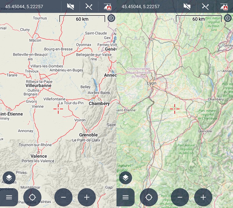
One example is Lyon at zoom 8 and 9 in Road theme. Please keep that the smaller cities' names are shown if nothing is nearby, e.g. Mâcon or Valence, so the right example is IMHO too much cleaned, because it makes orientation at signs difficult – same as if I zoom out as a workaround.


64df592b6fe13e681ce4aedf2d1962f3

Replies (1)

photo
1

Georg, this is beyond the capabilities of a standard OSM vector map.

One of the reasons I am creating the OAM World Maps with curated content. from zoom level 1 to 11/12/13 (depending on region). Curation for settlements comprises a classification by size, and bigger settlements are included at lower zoom levels than smaller ones. (Capitals - country, state, region, province - appear earlier as well.)

Those population categories (popcat in Tobias' Elevate/Elements OAM themes) are also included in Christian's OAM vector maps. And you can look into the theme file how that operates. And you will see Lyon earlier than those suburbs in OAM vector maps.

photo
1

I think there is a misunderstanding. In OAM with Elevate in mode City, "Lyon" is shown in zoom levels 7-14 so it makes at least the impression it is possible to show the city name when using vector maps – at least, France south OAM map is shown in Locus' top information bar, so I assume Locus did not automatically switch to OAM World Map, LoMap World or any other map "under the hood". I would simply like the same name display as OAM + Elevate in LoMaps 🙂 because switching back & forth map + theme is a bit cumbersome until switching map + theme is possible in one single go (idea).

OAM World Map at zoom level 8 is full of names and rivers – nice when one needs that, but bad if one just wants a overview of motorways (ways + numbers mostly hidden by the high amount of names).

LoMap "World" is over 6 years old and much more into direction of the overview use case, but a bit "too small" (just 14MB) as it does not contain any city name in the triangle Paris-Metz-Dijon of 26630km² – that's 1/3 of Czechia! – making orientation at road signs difficult.

photo
1

OAM/Elevate do show those towns/cities differently from LoMaps, BECAUSE the popcat mechanics is used for this vector map / theme. I only mentioned the world maps, because they were the reason popcat has been "invented".

It is up to the Locus team to mimic this mechanism.

photo
1

PS: I might try to create a version that massively reduces the number of settlements for ZL 8 in the OAM World Maps. Such can be used in the Maps/Advanced setting then without any switching. ZL 8 in vector mode is crap anyway - my view.

photo
1

Ah, I understand now – you pointed to the solution used in OAM 🙂

@Vector at ZL8: While I understand and second your main argument "low ZL asks for regional optimizations", on low ZL, a regional optimized Vector has the huge potential advantage that a user can configure what is visble and thus can achieve a nearly perfect overview map (very clear) for the current use case / information need. For example, user could choose via render theme options between display of surface type (forest/sand/etc), elevation, administrative borders, cities, peaks, national parks, major car / train / water network, time zones, ... – in any combination, without names xor with local names xor latin chars names, all up to ZL 11-12 with a file of only roughly 100 MByte because ways can be strongly simplified.

photo
1

Just an example for ZL 8- see attached.

At least at ZL 8-10 surface types are irrelevant, because you cannot really locate them and map to reality, I think. ZL 11-12 still questionable.

photo
1

For cyrillic areas.

You can have that now - nobody knows if and when the system you describe (and I agree this would be nice, if properly curated) would be available.

photo
1

At which ZL surface types become useful depends on the information need and the size of landscape type areas. In eastern France, ZL8 does only show loads of tiny fragments as your screenshot depitcs, which may already satisfy user's information neeed ("oh, no big homogenous surfaces here") – and if not, user simply zooms in where a smooth transition between "World" and detailed regional vector map would be great. In contrast. e.g. in Iceland already ZL8 shows large areas of vegatation, glacier, sand, tundra etc in OSM standard layer:


bff3cf19f99edf7988961ddaaca9172f

So from ZL8 you know you won't find a street suitable for cars across the glacier but only around, or you won't find many farms north of Vatnajökull but south of it. Likewise for Greenland, Tunesia, Australia etc.

While this discussion is interesting and maybe inspires someone to bring LoMaps' and OAM's "World" map to the next level "Vector for ZL1-11 with a bunch of rendering options", that is IMHO leading off-topic because it's IMHO an unlikely way the original post will be addressed – being about improving the built-in display of city names. I assume much more that only render theme "Road" will be reworked, because guideposts etc. about cities 200km away (requiring ZL8 or the like) are much more likely in a car setting than in a "Hike & bike" setting.

photo
2

True. But at least for the smooth transition between OAM World Maps and vector maps, Locus already has all the functionality you need.

photo
1

PS: OAM has a proper town/city selection (bigger ones dominate smaller ones): For LoMaps this would need an extension of their map generation process towards the way OAM does.

photo
1

"because switching back & forth map + theme is a bit cumbersome until switching map + theme is possible in one single go" - 2 taps: Preset button > preset name, with setting for each theme?

photo
1

@Andrew: I dont't yet use presets. Do I understand correctly that I'd need to add the preset button e.g. in right function bar and create one preset for each combination of maptype+theme+themeprofile? So in my case around 15 presets (3 map types LoMap3+4 and Mapsforge 5, each having 3-6 theme variations).

photo
Leave a Comment
 
Attach a file