
Bug? Extremely high estimated time after editing a GPX track in Route Planner
Known
Hi everyone,
I'm new to Locus Map and encountered a strange issue while editing a track using the Route Planner.
I'm using Locus Map v4.28.3 with gold plan on Android with LoRouter (offline).
The issue:
I imported a GPX file, and Locus initially displayed accurate statistics:
- Distance: 69.5 km
- Elevation gain: 4,029 m
- Estimated time: ~28 hours
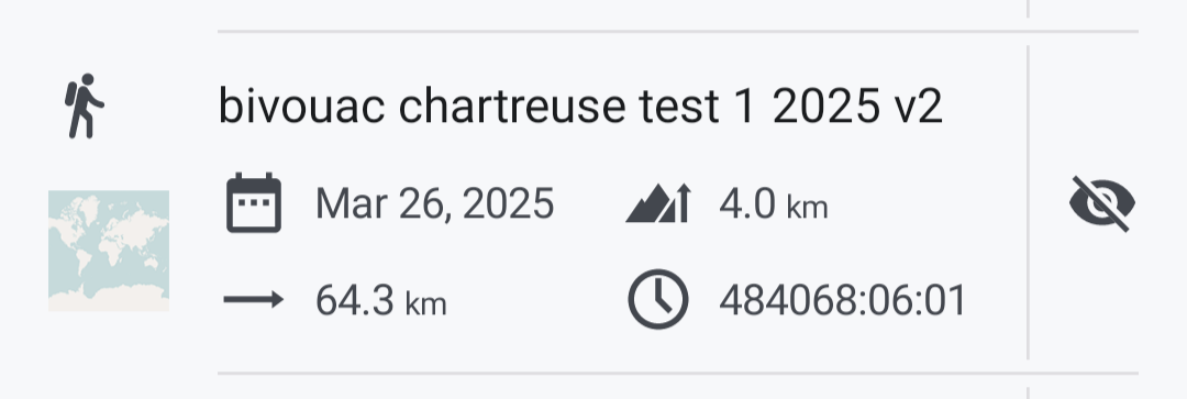
After editing the track to slightly shorten it (by moving a few points), the updated statistics after saving the new track showed:
- Distance: 64.3 km
- Elevation gain: 4,979 m
- Estimated time: 484,068 hours (!)
Even when opening the track in the web planner afterward, the same incorrect time is displayed.
What I’ve tried so far:
- Selected the affected portion of the track and used "Recalculate" — no change.
- Tried moving points around the problematic segment — still no effect.
- Exported and re-imported the GPX in Locus Map — issue persists.
- Exported the GPX, opened it in another planner app, then re-imported it into Locus Map — this workaround fixes the stats, but it’s not ideal.
Could this be a bug in the app, or am I doing something wrong when editing the track?
I've attached the GPX file in case it helps, not sure how to reproduce the issue though.
Thanks a lot for your help!
 The same problem
Hi Vincent,
could you please send the original track before the edit? Thanks
Hi Vincent,
could you please send the original track before the edit? Thanks
Hi Michal,
Sure, here is the original track right before the edit and that shows accurate estimated time, thanks !
Hi Michal,
Sure, here is the original track right before the edit and that shows accurate estimated time, thanks !
Thanks Vincent, I managed to replicate the issue. It was forwarded to the devs.
Thanks Vincent, I managed to replicate the issue. It was forwarded to the devs.
Thanks a lot for your reactivity Michal, feel free if you need more information.
Thanks a lot for your reactivity Michal, feel free if you need more information.
Hello,
I’ve noticed that incorrect estimated times seem to occur specifically when some (or all) segments of a track are marked as "manually drawn" (indicated by the pencil symbol).
To be more precise:
When I import a track from another source, all segments are detected as "manually drawn."
If I start editing this track using a hiking profile mode, the mix of manually drawn segments and hiking profile segments results in inaccurate estimated times.
Additionally, in similar conditions, I’ve seen cases where the estimated time is unrealistically low, such as 4 hours for a 60 km hike with 4,000+ meters of elevation gain.
As a orkarounds to fix this issue, I can either :
- Click "Recalculate All" (though this may slightly alter the track).
- Click "Recalculate" on each segment individually.
- Slightly move each segment point, which makes Locus to split it into two sub-segments with the correct routing mode.
By doing this, I can eliminate all manually drawn segments and restore accurate overall statistics.
Note: This might not be directly related, but when I create a track from scratch using the "Draw Manually" LoRouter profile, the estimated time remains at 0 / not defined, even though the distance and elevation profile show realistic data.
Hi there,
I encountered another strange behavior related to the estimated time calculation:
After clicking on "Recalculate all" using the Hiking profile with LoRouter online, the estimated time displayed is around 15 hours. However, if I slightly move a segment point—without changing the actual track (same distance and elevation)—the estimated time updates from 14:20 to 23:50 🤔
(See the attached video)
Hi Vincent,
we've finally gotten to dealing with this issue, and it seems to be a more complicated thing than we had anticipated. The tracks recorded by Komoot contain time values that mix with Locus Map router times, and the result is wrong. We have to do a major overhaul of this system, which will take some time.
Hi Michal,
Thanks having delve into it ! Didn't know this issue could've been related to tracks coming from Komoot. Does the issue occur only with tracks coming from Komoot, or can it occurs with other GPX sources ?
In the meantime, I have some workarounds available : use the "recalculate all" feature and fix possible shifted segments, or just re-draw the track from scratch.
Thanks again !
Replies have been locked on this page!