
Track slope glitch in WebPlanner but not identical track in LM4 app
I used Cloud Sync from the phone to the Web Planner for this route. In latest LM4 app v3.9.0 there is only +3.8% slope (as expected from contours) but in the WebPlanner the identical route (noticed for a 2nd time, reported for a different reason here) is a nonsense +25% slope, as calculated for very short section of the track. Is the Web Planner track auto-recalculated even when not modified? It reduces your confidence in planning the route via the WebPlanner, whereas it should be making life easier than using the app because of a bigger screen & mouse.
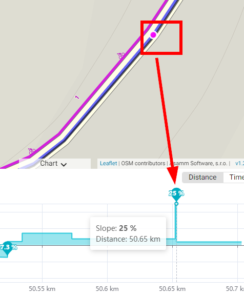
zoomed in even further shows how unreal this calculation is:
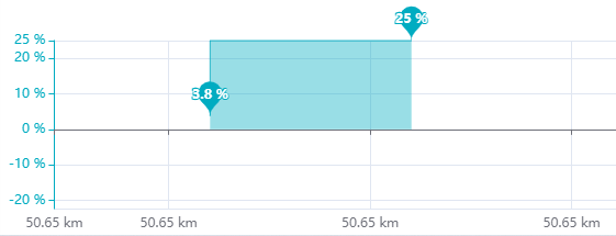
Also note above (minus) -20% on Y-axis above when the calculated minimum slope is only -7.3%, so the auto-scaling of the Y-axis could also be improved to maximize effective area of the chart (surely -10% to +25%) - another topic?
 The same problem
Hi Andrew, we are aware of this issue but we still have no easy, quick solution for it :/ ... as you have already pointed out this glitch is caused for very short section of the track when there is e.g. 0.25m (minimum altitude step in Brouter) altitude difference between point A and B that are 0.5m from each other ... the result is 50% slope.
We plan to add some more advanced filter for detecting and removing these outliers ... unfortunately, I have no ETA here :/. Any quick and easy ideas are welcome :).
Kind regards, Ondrej
22 months later - a new record of 337% slope - really? No advanced filtering like in LM4. It makes using the web planner to plan a route then check the slope almost useless when this happens because the actual/ real slope is reduced to a horizontal line.
example: https://link.locusmap.app/t/hjzgf5
Fortunately there is a workaround: import or Cloud Sync the route into LM4, and the slope glitch is entirely removed!! No update of elevation performed. Why the difference? And at this point 215m from the start, LM4 shows a transition from +7% to -7% over distance of 170m which is roughly true from the street view: https://www.google.com.au/maps/@-42.8749307,147.3333871,3a,90y,64.44h,81.89t/data=!3m7!1e1!3m5!1srWyw6jlC1gqyBjdmBXzhEg!2e0!6shttps:%2F%2Fstreetviewpixels-pa.googleapis.com%2Fv1%2Fthumbnail%3Fpanoid%3DrWyw6jlC1gqyBjdmBXzhEg%26cb_client%3Dmaps_sv.tactile.gps%26w%3D203%26h%3D100%26yaw%3D161.6578%26pitch%3D0%26thumbfov%3D100!7i16384!8i8192?entry=ttu
Hi Andrew, please, how was this track created? I have tried to plan the same in web planner and I can not create this glitch. Was it planned in the app? Which router? Thanks a lot.
Kind regards, Ondrej
Hi Andrew, please, how was this track created? I have tried to plan the same in web planner and I can not create this glitch. Was it planned in the app? Which router? Thanks a lot.
Kind regards, Ondrej
Hi Ondrej - thanks for checking. It was planned in the WebPlanner. Nothing unusual I can recall. I wasn't charting the slope while planning the route, so only noticed after saving. When I download (edit) the GPX & view in Garmin Basecamp, I can see a potential issue - point #11 appears to go backwards (180 degrees):
Hi Ondrej - thanks for checking. It was planned in the WebPlanner. Nothing unusual I can recall. I wasn't charting the slope while planning the route, so only noticed after saving. When I download (edit) the GPX & view in Garmin Basecamp, I can see a potential issue - point #11 appears to go backwards (180 degrees):
Hi Ondrej - what if a point near the glitch was dragged just slightly, enough (maybe) to create a duplicate point but still the exact same lat/lon? GPX below - 3 points with exact same lat/lon but different ele. The GPX is created by the Route Planner - it has to be a bug.
Hi Ondrej - what if a point near the glitch was dragged just slightly, enough (maybe) to create a duplicate point but still the exact same lat/lon? GPX below - 3 points with exact same lat/lon but different ele. The GPX is created by the Route Planner - it has to be a bug.
Hi Andrew,
Thanks for looking into the GPX. It appears we're not filtering the planned track, leading to points being too close and causing spikes in slope despite minimal altitude changes. I'll consult with the Android team to align our web filtering/smoothing approaches.
This seems to be a rare occurrence, likely related to OSM data quality, as points are usually spaced at least 1 meter apart. I've noted this for future updates, though I can't provide an ETA at the moment. Appreciate your report.
Kind regards, Ondrej
> Hi Ondrej - what if a point near the glitch was dragged just slightly, enough (maybe) to create a duplicate point but still the exact same lat/lon? GPX below - 3 points with exact same lat/lon but different ele. The GPX is created by the Route Planner - it has to be a bug.
It might not be an issue. Even though the longitude is the same, differing latitudes can result in varying elevations.
Replies have been locked on this page!